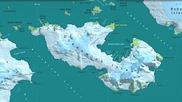
格林尼治島
 | |
| 地理 | |
|---|---|
| 位置 | 南極洲 |
| 坐标 | 62°31′S 59°47′W / 62.517°S 59.783°W / -62.517; -59.783 |
| 群岛 | 南設得蘭群島 |
| 面積 | 142.7平方公里(55.1平方英里) |
| 长度 | 15英里(24千米) |
| 宽度 | 3.25英里(5.23千米) |
| 最高海拔 | 625米(2,051英尺) |
| 管轄 | |
| 人口统计 | |
| 人口 | 0 |
| 其他资料 | |
根據南極條約體系管理 | |

Topographic map of Livingston Island, Greenwich, Robert, Snow and Smith Islands.
格林尼治島(英语:Greenwich Island)是南極洲的島嶼,屬於南設得蘭群島的一部分,位於羅伯特島和利文斯頓島之間,長24公里、闊5公里,面積142.7平方公里,島上最高點625米。
外部連結
Composite Antarctic Gazetteer.
Protected area Chile Bay (Discovery Bay).
| ||||||||||||||||||||||||
| 这是一篇與南极洲地理相關小作品。你可以通过编辑或修订扩充其内容。 |
