Bloomfield Hills, Michigan
City of Bloomfield Hills | ||
|---|---|---|
City | ||
 Gregor S. and Elizabeth B. Affleck House | ||
| ||
 Location in the state of Michigan | ||
| Coordinates: 42°35′01″N 83°14′44″W / 42.58361°N 83.24556°W / 42.58361; -83.24556Coordinates: 42°35′01″N 83°14′44″W / 42.58361°N 83.24556°W / 42.58361; -83.24556 | ||
| Country | United States | |
| State | Michigan | |
| County | Oakland | |
| Government [1] | ||
| • Type | Commission-Manager | |
| • Mayor | Sarah McClure | |
| • City Manager | David Hendrickson | |
| Area [2] | ||
| • City | 5.04 sq mi (13.05 km2) | |
| • Land | 4.96 sq mi (12.84 km2) | |
| • Water | 0.08 sq mi (0.21 km2) | |
| Elevation | 833 ft (254 m) | |
| Population (2010)[3] | ||
| • City | 3,869 | |
| • Estimate (2017)[4] | 3,990 | |
| • Density | 804.60/sq mi (310.65/km2) | |
| • Metro | 4,296,250 | |
| Time zone | UTC-5 (EST) | |
| • Summer (DST) | UTC-4 (EDT) | |
| ZIP code | 48304 | |
| Area code(s) | 248, 947 | |
| FIPS code | 26-09180[5] | |
GNIS feature ID | 0621616[6] | |
| Website | http://www.bloomfieldhillsmi.net | |

Bloomfield Hills is a city located in Metro Detroit's northern suburbs in Oakland County in the U.S. state of Michigan, 20.2 miles (32.5 km) northwest of downtown Detroit. The city is almost completely surrounded by Bloomfield Township. As of the 2010 census, the city population was 3,869.
Contents
1 History
2 Culture
2.1 Churches
3 Economy
4 Government
5 Geography
6 Demographics
6.1 2010 census
6.2 2000 census
7 Education
7.1 Primary and secondary schools
7.1.1 Public schools
7.1.2 Private schools
7.1.3 Weekend education
7.2 Post-secondary education
8 Notable people
9 See also
10 References
11 External links
History
On June 28, 1820, Oakland County was divided into two townships: Pontiac Township and Bloomfield Township, the latter covering the southern part of the county that would include West Bloomfield Township, Royal Oak and Southfield. What is now Bloomfield Hills was a farming area until the turn of the 20th century when wealthy Detroit residents bought up the land. The settlement became a village in 1927, and in 1932 residents voted to become a city to avoid being incorporated into growing Birmingham.
Culture
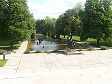
Cranbrook gardens
Bloomfield Hills is the location of the National Historic Landmark Cranbrook Educational Community and other historic sites listed on the national register of historic places.
In popular culture, Bloomfield Hills was the setting for the 2005 film The Upside of Anger. In the 2002 film 8 Mile, Eminem mentions Cranbrook Kingswood while making fun of "Doc" because he attended Cranbrook, which is not considered cool or impressive in the atmosphere portrayed in the film. Bloomfield Hills is the hometown of the comic book character, Trance. Some scenes in Out of Sight with Jennifer Lopez and George Clooney were filmed at a private residence in Bloomfield Hills. (In the novel by Elmore Leonard on which the film is based, the most prominent street in Bloomfield Hills is described as “Vaughan Road, nothing but money.”[7]) Jimmy Hoffa was last seen at the former Machus Red Fox restaurant in adjacent Bloomfield Township. The novel Gilda Joyce: The Ladies of the Lake is set in a private school in Bloomfield.
Churches

Kirk in the Hills
The area is the home of landmark churches including Kirk in the Hills Presbyterian on Long Lake Rd (Bloomfield Township) and Christ Church Cranbrook Episcopal, consecrated in 1928 as part of George Booth's plan for the Cranbrook Educational Community.[8] The Congregational Church of Birmingham United Church of Christ[9] was founded in Birmingham but moved to its present location in at 1000 Cranbrook Road (at Woodward Avenue) in Bloomfield Hills in 1966.[10] St. Hugo of the Hills Roman Catholic Church' was funded by Theodore F. MacManus (1872–1940) and his wife in memory of their deceased children, Hugo and Hubert. St. Hugo of the Hills Catholic Church was built from 1931–1936, with approval from Bishop Michael J. Gallagher, and was designed by Arthur DesRossiers.[11] Other churches include St. George Greek Orthodox, Bloomfield Hills Baptist, Beautiful Savior Lutheran Church (ELCA) on Adams Road (Bloomfield Township), Detroit Michigan Temple of The Church of Jesus Christ of Latter-day Saints, and Birmingham Unitarian Church on Woodward Avenue.[12][13]
Economy
Acme Group, consisting of Acme Mills, Great Lakes Filters, and Fairway Products, is headquartered in Bloomfield Hills.[14] Other companies headquartered in Bloomfield Hills, MI include Taubman Centers, TriMas Corp., Larson Realty Group, Princeton Enterprises, PulteGroup, Inc., TIP Capital, Bloomfield Hills Bancorp, Reverie, BlackEagle Partners, Gregory J. Schwartz & Co., Inc., Alidade Capital, and O2 Investment Partners.
Government
State officials
Governor Rick Snyder (R)
State Senator Jim Marleau (R) – 13th State Senate District[15][16]
State Representative Mike McCready (R) – 40th State House District[17]
Federal officials
Senator Gary Peters (D)
Senator Debbie Stabenow (D)
Representative David Trott (R) – 11th Congressional District
Geography
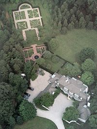
Woodland by Hugh T. Keyes, Bloomfield Hills estate of John Bugas
According to the United States Census Bureau, the city has a total area of 5.04 square miles (13.05 km2), of which 4.96 square miles (12.85 km2) is land and 0.08 square miles (0.21 km2) is water.[18]
Demographics
| Historical population | |||
|---|---|---|---|
| Census | Pop. | %± | |
| 1930 | 1,127 | — | |
| 1940 | 1,281 | 13.7% | |
| 1950 | 1,468 | 14.6% | |
| 1960 | 2,378 | 62.0% | |
| 1970 | 3,672 | 54.4% | |
| 1980 | 3,985 | 8.5% | |
| 1990 | 4,288 | 7.6% | |
| 2000 | 3,940 | −8.1% | |
| 2010 | 3,869 | −1.8% | |
| Est. 2017 | 3,990 | [4] | 3.1% |
| U.S. Decennial Census[19] | |||
As of the 2005–2009 American Community Survey 5-Year Estimates,[20] there were 3,774 people, 1,570 households, and about 1,382 families residing in the city. The population density was 796.4 per square mile (307.3/km²). There were 1,628 housing units at an average density of 329.1 per square mile (127.0/km²). The racial makeup of the city was 89.1% White, 5.4% Asian, 4.3% Black, 0.8% from other races, and 0.4% from two or more races. Hispanic or Latino of any race were 2.2% of the population.
2010 census
As of the census[3] of 2010, there were 3,869 people, 1,489 households, and 1,116 families residing in the city. The population density was 780.0 inhabitants per square mile (301.2/km2). There were 1,659 housing units at an average density of 334.5 per square mile (129.2/km2). The racial makeup of the city was 87.3% White, 6.7% Asian, 4.1% African American, 0.1% Native American, 0.3% from other races, and 1.6% from two or more races. Hispanic or Latino of any race were 1.5% of the population.
There were 1,489 households of which 25.7% had children under the age of 18 living with them, 67.7% were married couples living together, 4.9% had a female householder with no husband present, 2.4% had a male householder with no wife present, and 25.1% were non-families. 21.8% of all households were made up of individuals and 13% had someone living alone who was 65 years of age or older. The average household size was 2.44 and the average family size was 2.84.
The median age in the city was 54.1 years. 19.9% of residents were under the age of 18; 4.8% were between the ages of 18 and 24; 11.8% were from 25 to 44; 33.5% were from 45 to 64; and 29.7% were 65 years of age or older. The gender makeup of the city was 49.0% male and 51.0% female.
2000 census
As of the census[5] of 2000, There were 1,520 households out of which 26.2% had children under the age of 18 living with them, 71.9% were married couples living together, 3.2% had a female householder with no husband present, and 23.2% were non-families. 21.1% of all households were made up of individuals and 10.3% had someone living alone who was 65 years of age or older. The average household size was 2.45 and the average family size was 2.84.
In the city, the population was spread out with 19.7% under the age of 18, 3.8% from 18 to 24, 13.8% from 25 to 44, 39.0% from 45 to 64, and 23.8% who were 65 years of age or older. The median age was 52 years. For every 100 females, there were 89.8 males. For every 100 females age 18 and over, there were 85.8 males.
The median income for a household in the city was $170,790, and the median income for a family was over $200,000. Males had a median income of $100,000 versus $52,273 for females. The per capita income for the city was $104,920. About 1.8% of families and 3.8% of the population were below the poverty line, including 5.3% of those under age 18 and 6.4% of those age 65 and over.
Bloomfield Hills has the third highest income for a municipality with over 1,000 households in the country and the highest income in the state of Michigan. 39% of owner-occupied homes had a value of over $1,000,000, and 32.1% with a value between $500,000 to $999,999.[21]
Education
Primary and secondary schools
Public schools
Most of the city is served by the Bloomfield Hills School District (BHSD), a public school district based in neighboring Bloomfield Township, comprising the City of Bloomfield Hills, most of Bloomfield Township, and small parts of neighboring communities such as Auburn Hills, Troy, and West Bloomfield Township. The sole district comprehensive high school is Bloomfield Hills High School, formed in 2013 by the mergers of Andover High School and Lahser High School.[22][23]
The Bloomfield Hills district administers the International Academy, a tuition-free, public consortium high school in Bloomfield Township that hosts students from ten different public schools districts (including some Bloomfield Hills School District students).
A southern portion of Bloomfield Hills resides in the Birmingham City School District.[24]
Private schools
The Bloomfield Hills area is also home to many private schools. The city limits include the nonsectarian Cranbrook Schools, Cranbrook Academy of Art, St. Hugo of the Hills Catholic School, and the Roeper School. The neighboring communities of Bloomfield Township and Beverly Hills have two single-sex Catholic schools: Brother Rice High School for boys and Marian High School for girls, as well as the private college-preparatory school Detroit Country Day School, Academy of the Sacred Heart.[23]
Weekend education
After the Japanese School of Detroit was formed in 1973, it initially held its classes at Cranbrook School Brookside.[25]
Post-secondary education
Bloomfield Hills is home to the Cranbrook Academy of Art, one of the nation's leading graduate schools of architecture, art and design. It was founded by the Booths in 1932. By 1984, the New York Times would say that "the effect of Cranbrook and its graduates and faculty on the physical environment of this country has been profound ... Cranbrook, surely more than any other institution, has a right to think of itself as synonymous with contemporary American design."
The main offices of Oakland Community College are in Bloomfield Hills.[26][27]
Notable people
See also
- Oakland Hills Country Club
- Michigan locations by per capita income
- Woodward Corridor
References
^ "City of Bloomfield Hills". Bloomfieldhillsmi.net..mw-parser-output cite.citation{font-style:inherit}.mw-parser-output q{quotes:"""""""'""'"}.mw-parser-output code.cs1-code{color:inherit;background:inherit;border:inherit;padding:inherit}.mw-parser-output .cs1-lock-free a{background:url("//upload.wikimedia.org/wikipedia/commons/thumb/6/65/Lock-green.svg/9px-Lock-green.svg.png")no-repeat;background-position:right .1em center}.mw-parser-output .cs1-lock-limited a,.mw-parser-output .cs1-lock-registration a{background:url("//upload.wikimedia.org/wikipedia/commons/thumb/d/d6/Lock-gray-alt-2.svg/9px-Lock-gray-alt-2.svg.png")no-repeat;background-position:right .1em center}.mw-parser-output .cs1-lock-subscription a{background:url("//upload.wikimedia.org/wikipedia/commons/thumb/a/aa/Lock-red-alt-2.svg/9px-Lock-red-alt-2.svg.png")no-repeat;background-position:right .1em center}.mw-parser-output .cs1-subscription,.mw-parser-output .cs1-registration{color:#555}.mw-parser-output .cs1-subscription span,.mw-parser-output .cs1-registration span{border-bottom:1px dotted;cursor:help}.mw-parser-output .cs1-hidden-error{display:none;font-size:100%}.mw-parser-output .cs1-visible-error{font-size:100%}.mw-parser-output .cs1-subscription,.mw-parser-output .cs1-registration,.mw-parser-output .cs1-format{font-size:95%}.mw-parser-output .cs1-kern-left,.mw-parser-output .cs1-kern-wl-left{padding-left:0.2em}.mw-parser-output .cs1-kern-right,.mw-parser-output .cs1-kern-wl-right{padding-right:0.2em}
^ "2017 U.S. Gazetteer Files". United States Census Bureau. Retrieved Jan 3, 2019.
^ ab "American FactFinder". United States Census Bureau. Retrieved November 25, 2012.
^ ab "Population and Housing Unit Estimates". Retrieved March 24, 2018.
^ ab "American FactFinder". United States Census Bureau. Archived from the original on September 11, 2013. Retrieved 2008-01-31.
^ U.S. Geological Survey Geographic Names Information System: Bloomfield Hills, Michigan
^ Leonard, Elmore (1996). Out of Sight. Delacorte Press.
^ Christ Church Cranbrook web site Archived July 20, 2008, at the Wayback Machine.
^ "Congregational Church of Birmingham web site". Ccbucc.org.
^ CCB web site
^ St. Hugo website Archived July 5, 2008, at the Wayback Machine.
^ Birmingham Unitarian Church web site
^ "UUA web site". Uua.org. October 11, 2012.
^ Staff (1 October 2014). "Acme Group Adds 25,000+ SF Facility". Toledo Business Journal. Ohio, United States: Telex Communications. OCLC 759623182 – via HighBeam Research.
^ "Michigan's 38 Senate Districts" (PDF). 2011.
^ "Michigan Senate".
^ "Michigan House of Representatives".
^ "US Gazetteer files 2010". United States Census Bureau. Archived from the original on January 24, 2012. Retrieved November 25, 2012.
^ "Census of Population and Housing". Census.gov. Archived from the original on May 12, 2015. Retrieved June 4, 2015.
^ http://factfinder.census.gov. "2005–2009 American Community Survey 5-Year Estimates". US Census Bureau. Retrieved April 26, 2011.
^ "Table DP-3. Profile of Selected Economic Characteristics: 2000" (PDF).
^ "Home." Bloomfield Hills High School. Retrieved on July 30, 2013. "Bloomfield Hills High School Main Campus 3456 Lahser Road Bloomfield Hills, MI 48302" and "Bloomfield Hills High School 9th Grade Campus 2800 Lahser Bloomfield Hills, MI 48302"
^ ab "Bloomfield Township Street Map." (Archive) Bloomfield Township, Oakland County. Retrieved on July 30, 2013.
^ "Map" (Archive). Birmingham City School District. Retrieved on June 29, 2015.
^ "JSD History" (). Japanese School of Detroit. May 2, 2001. Retrieved on April 16, 2015. "昭和48年 6月 デトロイト日本語補習授業校開設、私立クランブルック・ブルックサイド校借用。 (1973)"
^ "Bloomfield Township Street Map." (Archive) Bloomfield Township, Oakland County. Retrieved on July 30, 2013.
^ "Campuses." Oakland Community College. Retrieved on June 20, 2015. "7. District Office 2480 Opdyke Rd. Bloomfield Hills, MI 48304-2266"
External links
| Wikimedia Commons has media related to Bloomfield Hills, Michigan. |
- City of Bloomfield Hills official website
Municipalities and communities of Oakland County, Michigan, United States | ||
|---|---|---|
County seat: Pontiac | ||
| Cities |
|  |
| Villages |
| |
| Charter townships |
| |
| General law townships |
| |
| Unincorporated communities |
| |
| Footnotes | ‡This populated place also has portions in an adjacent county or counties | |
Metro Detroit | ||
|---|---|---|
| Topics |
|  |
| Detroit |
| |
| Municipalities over 80,000 |
| |
| Municipalities 40,000 to 80,000 |
| |
| Cultural enclaves |
| |
| Satellite cities |
| |
| Counties in MSA |
| |
| Counties in CSA |
| |
| ||
Places adjacent to Bloomfield Hills, Michigan | ||||||||||
|---|---|---|---|---|---|---|---|---|---|---|
| ||||||||||


