洛隆县

Multi tool use
body.skin-minerva .mw-parser-output table.infobox caption{text-align:center}
洛隆县 |
 昌都市下属行政区划 |
概览 |
国家 |
中华人民共和国
|
隶属行政区 |
西藏自治区昌都市
|
区划类别 |
县
|
区划代码 |
542132 |
政府驻地 |
孜托镇 |
乡级行政区数 |
16 |
- 镇数 |
1 |
- 乡数 |
15 |
地理 |
总面积 |
8,108 平方千米 |
人口及經濟 |
总人口(2003) |
4万人 |
其它 |
时区 |
UTC+8(北京时间) |
邮政编码 |
855400 |
电话区号 |
+86 (0)895
|
網站:洛隆县政府网
|
洛隆县(藏文:.mw-parser-output .uchen{font-family:"Qomolangma-Dunhuang","Qomolangma-Uchen Sarchen","Qomolangma-Uchen Sarchung","Qomolangma-Uchen Suring","Qomolangma-Uchen Sutung","Qomolangma-Title","Qomolangma-Subtitle","Qomolangma-Woodblock","DDC Uchen","DDC Rinzin",Kailash,"BabelStone Tibetan",Jomolhari,"TCRC Youtso Unicode","Tibetan Machine Uni",Wangdi29,"Noto Sans Tibetan","Microsoft Himalaya"}.mw-parser-output .ume{font-family:"Qomolangma-Betsu","Qomolangma-Chuyig","Qomolangma-Drutsa","Qomolangma-Edict","Qomolangma-Tsumachu","Qomolangma-Tsuring","Qomolangma-Tsutong","TibetanSambhotaYigchung","TibetanTsugRing","TibetanYigchung"}ལྷོ་རོང་རྫོང,藏语拼音:Lhorong Zong,威利:lho rong rdzong)位于中國西藏自治區东部、怒江上游,是昌都市西南部的一個縣,藏语意思为“南谷”。
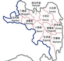
地理位置东经95°20'-96°32',北纬30°15'-31°15'。与之接壤的县市有:东边八宿县,南边波密县,西边边坝县,北边丁青县、类乌齐县。全縣面积8108平方公里,2003年人口4万。
該縣為1959年,將原本的洛隆宗和硕督宗合并成立的。
行政区划
下辖:[1]孜托镇、硕督镇、康沙镇、马利镇、玉西乡、新荣乡、达龙乡、腊久乡、俄西乡、中亦乡和白达乡。
参考资料
^ 2017年统计用区划代码和城乡划分代码:洛隆县. 中华人民共和国国家统计局. 2017.
- A. Gruschke: The Cultural Monuments of Tibet’s Outer Provinces: Kham - Volume 1. The Xizang Part of Kham (TAR), White Lotus Press, Bangkok 2004. ISBN 974-480-049-6
- Tsering Shakya: The Dragon in the Land of Snows. A History of Modern Tibet Since 1947, London 1999, ISBN 0-14-019615-3
洛隆县行政区划
|
|
行政隶属:中华人民共和国西藏自治区昌都地区
|
|
镇 |
|
|
乡 |
- 玉西乡
- 新荣乡
- 达龙乡
- 腊久乡
- 俄西乡
- 中亦乡
- 白达乡
|
|
参见:西藏自治区乡级以上行政区列表
|
|
西藏自治区行政区划
|
|
国别:中华人民共和国 首府:拉萨市
|
|
地级行政区 |
74县级行政区(8市辖区、66县) |
|
|
地级市 |
拉萨市 |
城关区 · 堆龙德庆区 · 达孜区 · 林周县 · 当雄县 · 尼木县 · 曲水县 · 墨竹工卡县
|
|
日喀则市 |
桑珠孜区 · 南木林县 · 江孜县 · 定日县 · 萨迦县 · 拉孜县 · 昂仁县 · 谢通门县 · 白朗县 · 仁布县 · 康马县 · 定结县 · 仲巴县 · 亚东县 · 吉隆县 · 聂拉木县 · 萨嘎县 · 岗巴县
|
|
昌都市 |
卡若区 · 江达县 · 贡觉县 · 类乌齐县 · 丁青县 · 察雅县 · 八宿县 · 左贡县 · 芒康县 · 洛隆县 · 边坝县
|
|
林芝市 |
巴宜区 · 工布江达县 · 米林县 · 墨脱县 · 波密县 · 察隅县 · 朗县
|
|
山南市 |
乃東區 · 扎囊县 · 贡嘎县 · 桑日县 · 琼结县 · 曲松县 · 措美县 · 洛扎县 · 加查县 · 隆子县 · 错那县 · 浪卡子县
|
|
那曲市 |
色尼区 · 嘉黎县 · 比如县 · 聂荣县 · 安多县 · 申扎县 · 索县 · 班戈县 · 巴青县 · 尼玛县 · 双湖县
|
|
|
地区 |
阿里地区 |
噶尔县 · 普兰县 · 札达县 · 日土县 · 革吉县 · 改则县 · 措勤县
|
|
|
注:错那县、隆子县、朗县、米林县、墨脱县和察隅县的南面土地,统称藏南地區,未实际統治,參见中印边界问题。 参见:中华人民共和国县级以上行政区列表、西藏自治区乡级以上行政区列表。
区划索引:单位(代码):省级(史)>副省级>地级>县级:京|津|冀|晋|蒙|辽|吉|黑|沪|苏|浙|鲁|皖|赣|闽|豫|鄂|湘|粤|桂|琼|渝|川|贵|云|藏|陕|甘|青|宁|新|港|澳|台
|
|
mYNQ7hLxT2rU6 fzOcWYqPijm1M9hB5Wq
Popular posts from this blog
This article is about the letter of the alphabet. For other uses, see Y (disambiguation). See also: Wye (disambiguation) Y Y y (See below) Usage Writing system Latin script Type Alphabetic and Logographic Language of origin Latin language Phonetic usage [ y ] [ ɨ ] [ j ] [ iː ] [ ɪ ] [ ɘ ] [ ə ] [ ɯ ] [ ɛː ] [ j ] [ ɥ ] [ ɣ̟ ] / w aɪ / / aɪ / Unicode value U+0059, U+0079 Alphabetical position 25 History Development Υ υ 𐌖 Y y Time period 54 to present Descendants • U • V • W • Ỿ • ¥ • Ꮙ • Ꮍ • Ꭹ Sisters F Ѵ У Ў Ұ Ү ו و ܘ וּ וֹ ࠅ 𐎆 𐡅 ወ વ ૂ ુ उ Variations (See below) Other Other letters commonly used with y(x), ly, ny This article contains IPA phonetic symbols. Without proper rendering support, you may see question marks, boxes, or other symbols instead of Unicode characters. For an introductory guide on IPA symbols, see Help:IPA. ISO basic Latin alphabet Aa Bb Cc D...
Mount Tamalpais Mount Tamalpais, viewed from the south Highest point Elevation 2,571 ft (784 m) NAVD 88 [1] Prominence 2,456 ft (749 m) [1] Listing California county high points 55th Coordinates 37°55′45″N 122°34′40″W / 37.929088°N 122.577829°W / 37.929088; -122.577829 Coordinates: 37°55′45″N 122°34′40″W / 37.929088°N 122.577829°W / 37.929088; -122.577829 [1] Geography Mount Tamalpais Marin County, California, U.S. Show map of California Mount Tamalpais Mount Tamalpais (the US) Show map of the US Parent range California Coast Ranges Topo map USGS San Rafael Geology Mountain type Sedimentary Climbing First ascent 1830s by Jacob P. Leese (first recorded ascent) [2] Easiest route Railroad Grade fire trail Mount Tamalpais ( / t æ m əl ˈ p aɪ . ɪ s / ; TAM -əl- PY -iss ; Coast Miwok: /t̪ɑmɑlˈpɑis̺/ , known locally as Mount Tam ) is a peak in Marin County, California, United State...
FMW Women's Championship Details Promotion Frontier Martial-Arts Wrestling [1] Date established November 5, 1990 [1] Date retired September 28, 1997 Other name(s) WWA World Women's Championship FMW Independent Women's Championship Statistics First champion(s) Combat Toyoda [1] Most reigns Megumi Kudo (6 reigns) [1] Longest reign Megumi Kudo (426 days) [1] Shortest reign Shark Tsuchiya (<1 day) [1] The FMW Women's Championship (or the FMW Independent Women's & WWA Women's Championship ) was two Japanese women's professional wrestling championships (WWA World Women's Championship and FMW Independent World Women's Championship) contested in the promotion Frontier Martial-Arts Wrestling (FMW). During the heyday of FMW, the female wrestlers wrestled in the same types of bloody death matches as the FMW men, and were feared by other Japanese female wrestlers for their toughness and intensity. ...