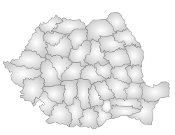
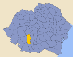
Vâlcea County
Vâlcea County Județul Vâlcea | ||
|---|---|---|
County | ||
| ||
 | ||
| Coordinates: 45°05′N 24°07′E / 45.08°N 24.11°E / 45.08; 24.11Coordinates: 45°05′N 24°07′E / 45.08°N 24.11°E / 45.08; 24.11 | ||
| Country | Romania | |
| Development region | Sud-Vest | |
| Historical region | Muntenia, Oltenia | |
| Capital | Râmnicu Vâlcea | |
| Area | ||
| • Total | 5,765 km2 (2,226 sq mi) | |
| Area rank | 20th | |
| Population (2011) | ||
| • Total | 355,320 | |
| • Rank | 26th | |
| • Density | 62/km2 (160/sq mi) | |
| Telephone code | (+40) 250 or (+40) 350[1] | |
| ISO 3166 code | RO-VL | |
| Website | County Council Prefecture | |
Vâlcea County (also spelt Vîlcea; Romanian pronunciation: [ˈvɨlt͡ʃe̯a]) is a county (județ) of Romania. Located in the historical regions of Oltenia and Muntenia (which are separated by the Olt River), it is also part of the wider Wallachia region. Its capital city is Râmnicu Vâlcea.
Contents
1 Demographics
2 Geography
2.1 Neighbours
3 Economy
4 Tourism
5 Politics
6 Administrative divisions
7 Historical county
7.1 Administration
7.2 Population
7.2.1 Urban population
8 References
9 External links
Demographics
In 2011, it had a population of 355,320 and the population density was 61.63/km².
Romanians - over 98%[2]
Roma, others.
| Year | County population[3] |
|---|---|
| 1948 | 341,590 |
| 1956 | |
| 1966 | |
| 1977 | |
| 1992 | |
| 2002 | |
| 2011 |
Geography
This county has a total area of 5,765 km².
The North side of the county is occupied by the mountains from the Southern Carpathians group - The Făgăraș Mountains in the East with heights over 2200 m, and the Lotru Mountains in the West with heights over 2000 m. They are separated by the Olt River valley - the most accessible passage between Transylvania and Muntenia. Along the Olt River Valley there are smaller groups of mountains, the most spectacular being the Cozia Mountains.
Towards the South, the heights decrease, passing through the sub-carpathian hills to a high plain in the West side of the Romanian Plain.
The main river is the Olt River crossing the county from North to South. Its main affluents are the Lotru River in the North and the Olteț River in the South.
Neighbours
Argeș County in the East.
Gorj County and Hunedoara County in the West.
Sibiu County and Alba County in the North.
Dolj County and Olt County in the South.
Economy
The city of Râmnicu Vâlcea is the most industrialised in the county, the rest of the county having an agrarian development.
The predominant industries in the county are:
- Chemical industry.
- Food and beverage industry.
- Textile industry.
- Mechanical components industry.
- Construction materials.
- Wood and furniture industry.
In the West of the county coal and salt are extracted.
The area in the center of the county is well suited for fruit orchards, wines and raising cattle. The South is better suited for growing cereals and vegetables.
More information about Valcea County economy on Valcea Chamber of Commerce and Industry http://www.ccivl.ro
Tourism
The main tourist destinations are:
- The Olt River Valley:
- The Călimănești-Căciulata resorts
- The Cozia Monastery.
- The Turnu Monastery.
- The Cozia Mountains.
- Various small churches and fortifications.
- The Lotru River valley:
- The town of Brezoi.
- The Lotru Mountains.
- The Voineasa Resort
- The Vidra Resort
- The Obârșia Lotrului Resort.
- The city of Râmnicu Vâlcea.
- The Băile Govora Resort.
- The Băile Olănești Resort.
Politics
The Vâlcea County Council, elected at the 2016 local government elections, is made up of 33 counselors, with the following party composition:[4]
| | Party | Seats | Current County Council | |||||||||||||
|---|---|---|---|---|---|---|---|---|---|---|---|---|---|---|---|---|
| | Social Democratic Party | 14 | | | | | | | | | | | | | | |
| | National Liberal Party | 13 | | | | | | | | | | | | | | |
| | Alliance of Liberals and Democrats | 3 | | | | | | | | | | | | | | |
| | Ecologist Party | 3 | | | | | | | | | | | | | | |
Administrative divisions
Vâlcea County has 2 municipalities, 9 towns and 78 communes
- Municipalities
- Drăgășani
Râmnicu Vâlcea - capital city; population: 92,573 (as of 2011)
- Towns
- Băbeni
- Băile Govora
- Băile Olănești
- Bălcești
- Berbești
- Brezoi
- Călimănești
- Horezu
- Ocnele Mari
- Communes
- Alunu
- Amărăști
- Bărbătești
- Berislăvești
- Boișoara
- Budești
- Bujoreni
- Bunești
- Câineni
- Cernișoara
- Copăceni
- Costești
- Crețeni
- Dăești
- Dănicei
- Diculești
- Drăgoești
- Fârtățești
- Făurești
- Frâncești
- Galicea
- Ghioroiu
- Glăvile
- Golești
- Grădiștea
- Gușoeni
- Ionești
- Lăcusteni
- Lădești
- Laloșu
- Lăpușata
- Livezi
- Lungești
- Măciuca
- Mădulari
- Malaia
- Măldărești
- Mateești
- Mihăești
- Milcoiu
- Mitrofani
- Muereasca
- Nicolae Bălcescu
- Olanu
- Orlești
- Oteșani
- Păușești
- Păușești-Măglași
- Perișani
- Pesceana
- Pietrari
- Popești
- Prundeni
- Racovița
- Roești
- Roșiile
- Runcu
- Sălătrucel
- Scundu
- Sinești
- Șirineasa
- Slătioara
- Stănești
- Ştefănești
- Stoenești
- Stoilești
- Stroești
- Șușani
- Sutești
- Tetoiu
- Titești
- Tomșani
- Vaideeni
- Valea Mare
- Vlădești
- Voicești
- Voineasa
- Zătreni
Historical county
Județul Vâlcea | ||
|---|---|---|
County (Județ) | ||
 The building of the Vâlcea County court from the interwar period, now the Râmnicu Vâlcea court. | ||
| ||
 | ||
| Country | ||
| Historic region | Oltenia | |
| Capital city (Reședință de județ) | Râmnicu Vâlcea | |
| Area | ||
| • Total | 4,081 km2 (1,576 sq mi) | |
| Population (1930) | ||
| • Total | 246,659 | |
| • Density | 60/km2 (160/sq mi) | |
| Time zone | UTC+2 (EET) | |
| • Summer (DST) | UTC+3 (EEST) | |
Historically, the county was located in the southwestern part of Greater Romania, in the northeast part of the historical region of Oltenia. Its capital was Râmnicu Vâlcea. The interwar county territory comprised a large part of the current Vâlcea County; however the territories situated to the east of the Olt River in the current county were not part of the historical county.
The county was bordered to the north by Sibiu County, to the east by the counties of Argeş and Olt, to the south by Romanați County, and to the west by the counties of Dolj and Gorj.
Administration

Map of Vâlcea County as constituted in 1938.
The county was in 1930 divided into five administrative districts (plăṣi):[5]
- Plasa Cerna, headquartered at Lădești
- Plasa Cozia, headquartered at Călimănești
- Plasa Drăgășani, headquartered at Drăgășani
- Plasa Horezu, headquartered at Horezu
- Plasa Zătreni, headquartered at Zătreni
By 1938, there were six districts, four previous and two new ones resulting from the reorganisation of the southwest part of the county:[6]
- Plasa Cerna, headquartered at Lădești
- Plasa Cozia, headquartered at Călimănești
- Plasa Drăgășani, headquartered at Drăgășani
- Plasa Horezu, headquartered at Horezu
- Plasa Bălcești, headquartered at Bălcești
- Plasa Oltețu, headquartered at Oltețu
Population
According to the 1930 census data, the county population was 246,713 inhabitants, ethnically divided as follows: 97.4% Romanians, 1.6% Romanies, 0.2% Germans, 0.2% Hungarians, 0.2% Jews, as well as other minorities. From the religious point of view, the population was 99.0% Eastern Orthodox, 0.4% Roman Catholic, 0.2% Jewish, as well as other minorities.
Urban population
In 1930, the county's urban population was 31,909 inhabitants, comprising 94.8% Romanians, 1.3% Romanies, 1.0% Germans, 0.8% Jews, 0.7% Hungarians, as well as other minorities. From the religious point of view, the urban population was composed of 96.4% Eastern Orthodox, 1.4% Roman Catholic, 0.8% Jewish, 0.7% Lutheran, 0.3% Greek Catholic, as well as other minorities.
References
| Wikimedia Commons has media related to Vâlcea County. |
^ The number used depends on the numbering system employed by the phone companies on the market.
^ National Institute of Statistics, "Populația după etnie" Archived 2009-08-16 at the Wayback Machine
^ National Institute of Statistics, [1]
^ "Mandate de CJ pe judete si competitori" (in Romanian). Biroul Electoral Central. 10 June 2016. Retrieved 16 June 2016..mw-parser-output cite.citation{font-style:inherit}.mw-parser-output .citation q{quotes:"""""""'""'"}.mw-parser-output .citation .cs1-lock-free a{background:url("//upload.wikimedia.org/wikipedia/commons/thumb/6/65/Lock-green.svg/9px-Lock-green.svg.png")no-repeat;background-position:right .1em center}.mw-parser-output .citation .cs1-lock-limited a,.mw-parser-output .citation .cs1-lock-registration a{background:url("//upload.wikimedia.org/wikipedia/commons/thumb/d/d6/Lock-gray-alt-2.svg/9px-Lock-gray-alt-2.svg.png")no-repeat;background-position:right .1em center}.mw-parser-output .citation .cs1-lock-subscription a{background:url("//upload.wikimedia.org/wikipedia/commons/thumb/a/aa/Lock-red-alt-2.svg/9px-Lock-red-alt-2.svg.png")no-repeat;background-position:right .1em center}.mw-parser-output .cs1-subscription,.mw-parser-output .cs1-registration{color:#555}.mw-parser-output .cs1-subscription span,.mw-parser-output .cs1-registration span{border-bottom:1px dotted;cursor:help}.mw-parser-output .cs1-ws-icon a{background:url("//upload.wikimedia.org/wikipedia/commons/thumb/4/4c/Wikisource-logo.svg/12px-Wikisource-logo.svg.png")no-repeat;background-position:right .1em center}.mw-parser-output code.cs1-code{color:inherit;background:inherit;border:inherit;padding:inherit}.mw-parser-output .cs1-hidden-error{display:none;font-size:100%}.mw-parser-output .cs1-visible-error{font-size:100%}.mw-parser-output .cs1-maint{display:none;color:#33aa33;margin-left:0.3em}.mw-parser-output .cs1-subscription,.mw-parser-output .cs1-registration,.mw-parser-output .cs1-format{font-size:95%}.mw-parser-output .cs1-kern-left,.mw-parser-output .cs1-kern-wl-left{padding-left:0.2em}.mw-parser-output .cs1-kern-right,.mw-parser-output .cs1-kern-wl-right{padding-right:0.2em}
^ Portretul României Interbelice - Județul Vâlcea
^ Istorie locală - Județul Vâlcea în perioada 1920-1940
External links
Vâlcea County, Romania | ||
|---|---|---|
| Cities |
|  |
| Towns |
| |
| Communes |
| |
Counties (județe) of Romania | ||
|---|---|---|
| ||


