Rif Dimashq Governorate
Rif Dimashq Governorate مُحافظة ريف دمشق | |
|---|---|
Governorate | |
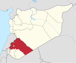
 Map of Syria with Rif-dimashq highlighted | |
| Coordinates (Damascus): 33°30′N 37°00′E / 33.5°N 37°E / 33.5; 37Coordinates: 33°30′N 37°00′E / 33.5°N 37°E / 33.5; 37 | |
| Country | |
| Capital | Douma |
| Manatiq (Districts) | 10 |
| Area | |
| • Total | 18,032 km2 (6,962 sq mi) |
| Population (2011) | |
| • Total | 2,836,000 |
| • Density | 160/km2 (410/sq mi) |
| Time zone | UTC+2 (EET) |
| • Summer (DST) | UTC+3 (EEST) |
| ISO 3166 code | SY-RD |
| Main language(s) | Arabic |
Rif Dimashq Governorate (Arabic: محافظة ريف دمشق Moḥaafaẓat Reef Demashq, literally, the "Governorate of the Countryside of Damascus") is one of the fourteen governorates (provinces) of Syria. It is situated in the southwestern part of the country. It borders the governorates of Quneitra, Daraa and al-Suwayda (comprising the historic Hauran region) in the southwest, Homs in the north, Lebanon in the west and Jordan in the south.
The Governorate completely surrounds the city-governorate of Damascus and it has an area of 18,032 km² and a population of 2,273,074 (2004 census).[1]
The Governorate was a major site of fighting in the Syrian Civil War - see Rif Dimashq Governorate campaign.
Districts
The governorate is divided into ten districts (manatiq). There were nine district until February 2009, when Qudsaya District was created from parts of Markaz Rif Dimashq and Al-Zabadani districts. The districts are further divided into 37 sub-districts (nawahi).
| Districts | Population (Census 2004) |
|---|---|
Markaz Rif Dimashq | 837,804 |
Douma | 433,719 |
Al-Qutayfah | 119,283 |
Al-Tall | 115,937 |
Yabroud | 48,370 |
An-Nabek | 80,001 |
Al-Zabadani | 63,780 |
Qatana | 207,245 |
Darayya | 260,961 |
Qudsaya | 105,974 |
Total Governorate | 2,273,074 |
Map of districts until February 2009

Rif Dimashq
References
^ Rif Dimashq total population as of 2004 official census Archived 2013-01-12 at Archive.today
This article about a location in Rif Dimashq Governorate, Syria is a stub. You can help Wikipedia by expanding it. |

