Genesee River
| Genesee River | |
|---|---|
 Genesee River near Belmont | |
 Map of Genesee River | |
| Native name | Čunehstí•yu•[1] |
| Location | |
| Country | United States |
| State | New York, Pennsylvania |
Counties & Tributaries | (see Navbox, below) |
| City | Rochester, NY |
| Physical characteristics | |
| Source | |
| - location | Ulysses Township, Potter County, Pennsylvania |
| - coordinates | 41°53′33″N 77°43′54″W / 41.89250°N 77.73167°W / 41.89250; -77.73167[3] |
| - elevation | 2,275 ft (693 m)[2] |
| Mouth | Lake Ontario |
Charlotte, Rochester, Monroe County, New York | |
- coordinates | 43°15′30″N 77°36′08″W / 43.25833°N 77.60222°W / 43.25833; -77.60222Coordinates: 43°15′30″N 77°36′08″W / 43.25833°N 77.60222°W / 43.25833; -77.60222[3] |
- elevation | 243 ft (74 m)[3] |
| Length | 157 mi (253 km) |
| Basin size | 2,500 sq mi (6,500 km2) |
| Discharge | |
| - location | Lake Ontario |
| Discharge | |
| - location | Portageville, NY |
The Genesee River is a tributary of Lake Ontario flowing northward through the Twin Tiers of Pennsylvania and New York in the United States.
The river provided the original power for the Rochester area's 19th century mills and still provides hydroelectric power for downtown Rochester.
Contents
1 Geology
2 History
2.1 Crossings
2.2 Floods
3 Literature
4 See also
5 References
6 External links
Geology
The Genesee is the remaining western branch of a preglacial system, with rock layers tilted an average of 40 feet (12 m) per mile, so the river flows across progressively older bedrock as it flows northward. It begins in exposing the Allegheny Plateau's characteristic conglomerates: sandstones and shales in the rock columns of the Mississippian and Pennsylvanian subperiods. Thereafter, further downstream as it traverses the area known as The Grand Canyon of the East,[4] where it falls (three times) through over 600 feet (180 m)[4] as to passes through the gorges in New York's Letchworth State Park, the river also often exposes older rocks such as shales (some rich in hydrocarbons[5]), siltstones and some limestones of the Devonian period at Letchworth and, at other canyons with three more waterfalls[6][7][8] at Rochester cuts through the Niagara Escarpment exposing limestones and shales of Silurian age in the rock column. With cuttings in the geologic record showing so many early ages, the river area has a great variety of fossils for paleobiological and stratigraphic analysis.
History
During the past million years there were four glacial ages that covered the Rochester area with the southern edges of the Laurentide Ice Sheet and those advances were major impactors in the formation geology and geography of the area. The most recent glacier that left evidence here was about 100,000 years ago and it caused compression of the earth by as much as 2,500 feet (760 m).[9] About 12,000 years ago, the area underwent massive changes, which included the rerouting of the Genesee and other water bodies. The pre-ice age eastern branch of the Genesee runs south of Mount Morris and was completely diverted by extensive terminal moraines in Livingston County with a key blocking dam just south of Dansville, so most of the upper section of the ancient river was diverted instead to fall the off Appalachian Plateau toward the Susquehanna River system (to an eventual destination well to the southeast).
Currently only a small creek flows in what is left of this large paleogeologic valley. The area of the lower river was also affected. Since the earth rebounded from the melting glaciers more rapidly in Canada than in New York, water from Lake Ontario was spilled over New York due to its lower elevation. During this time, the original outlet of the Genesee River, Irondequoit Bay, was flooded out, creating the current bay. As these waters later retreated, glacial debris caused the river to be rerouted to the west along its current path.[10]
The Seneca nation traditionally lived between the Genesee River and Canandaigua Lake. The region was surveyed by Thomas Davies in 1766. The High Falls was then also known as the Great Seneca Falls, and the Genesee River was also spelled Zinochsaa by early writers.[11]
If "not for hydropower, the flour mills, clothing mills, and tool fabricators would not have located in Rochester",[12] and the 1825 Erie Canal allowed the mills to ship products to New York City. A few hundred feet north of the center of the village of Rochester, the Erie Canal crossed the Genesee River via an 1823 stone aqueduct (802 feet (244 m) long, 17 feet (5.2 m) wide), which was replaced by the Second Genesee Aqueduct in 1842.
Historically, the river's gorge formed an clearly demarcated border between the lands of the Five Nations of the Iroquois, whose range extended east and the related tribes of the Erie people along the west side of the gorge. By the end of the Beaver Wars and the American Revolution, the lands in all of upstate New York into the Ohio Country were controlled by the Iroquois Confederation, but were also effectively depopulated, the tribes weakened in the Revolution. Subsequently, with most Iroquois having fled to Canada, the remnant tribal groups were in no position to further impede white settlers, so most of New York state west of the Genesee River became part of the Holland Purchase after the American Revolution. From 1801 to 1846 the entire region was sold to individual owners from the Holland Land office in Batavia, New York. The river demarcates the "Genesee Country" of New York to the west and the Finger Lakes geographic region, and heartland of the Iroquois to the east.
On Friday, November 13, 1829 (Friday the 13th), the daredevil Sam Patch jumped to his death before 8,000 spectators at the Upper Falls in Rochester.
In 1836 the Genesee Valley Canal was begun to build a new canal from the Erie Canal near Rochester, up the Genesee Valley, across to the Allegheny River at Olean. Construction of new sections extended upriver (southward) until 1880. Although an important commercial route, the canal was plagued by frequent flood damage and the final leg down the Allegany River was never completed. The most difficult section to build was the bypass around the gorge and falls at present day Letchworth Park. The canal followed the old Native American portage route, which necessitated many locks. These old locks can still be seen near Nunda. The project was abandoned and the right of way was sold in 1880. The property became the roadbed for the Genesee Valley Canal Railroad, which eventually merged with the Pennsylvania Railroad. Much of the canal and railroad right-of-way is open to the public today as the Genesee Valley Greenway, which was started in 1991.
In 1852 a wooden railroad bridge was built over the Upper Falls at Portageville. It was the largest of all wooden bridges built at the time.[citation needed] The wood from 300 acres (1.2 km²) of trees was required for its timber. In the "summer of 1943", Arch Merrill walked the length of the Genesee River.[13]
Crossings
Floods
A March 1865 thaw was the worst Genesee flood in Rochester history, and a similar 1913 flood motivated the excavation of the Genesee's rock bed in Downtown Rochester. The 1972 Hurricane Agnes flood broke all county historical records, with the most concentrated damage in the Wellsville area.[14][15] The water from Hurricane Agnes caused the only instance where the river's flow exceeded the storage capacity of the reservoir of the Mount Morris Dam, the largest flood control dam east of the Mississippi, and water had to be released from the dam to prevent overtopping of the spillway.
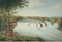
A View of the Casconchiagon or Great Seneca Falls, Lake Ontario, taken 1766 by Thomas Davies

The High Falls in downtown Rochester
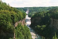
The Middle Falls in Letchworth State Park

Genesee River in the Town of Caneadea


Literature
The Genesee has been the subject of books and poetry.
By the Genesee: Rhymes and Verses by Thomas Thackeray Swinburne (1900)
A River Ramble: Saga of the Genesee Valley by Arch Merrill (1943). A walk along the Genesee from its source to its mouth
Genesee Fever by Carl Carmer. Novel about the early settlement of the Genesee Valley (1941)
The Genesee by Henry W. Clune, part of the Rivers of America Series (1963)
Valley of the Genesee: A Poem by Charles Edwin Furman (1879)
See also
- List of rivers of New York
- List of rivers of Pennsylvania
References
^ Peck, William (1908). History of Rochester and Monroe county, New York. The Pioneer publishing company. p. 15. Retrieved April 4, 2009..mw-parser-output cite.citation{font-style:inherit}.mw-parser-output .citation q{quotes:"""""""'""'"}.mw-parser-output .citation .cs1-lock-free a{background:url("//upload.wikimedia.org/wikipedia/commons/thumb/6/65/Lock-green.svg/9px-Lock-green.svg.png")no-repeat;background-position:right .1em center}.mw-parser-output .citation .cs1-lock-limited a,.mw-parser-output .citation .cs1-lock-registration a{background:url("//upload.wikimedia.org/wikipedia/commons/thumb/d/d6/Lock-gray-alt-2.svg/9px-Lock-gray-alt-2.svg.png")no-repeat;background-position:right .1em center}.mw-parser-output .citation .cs1-lock-subscription a{background:url("//upload.wikimedia.org/wikipedia/commons/thumb/a/aa/Lock-red-alt-2.svg/9px-Lock-red-alt-2.svg.png")no-repeat;background-position:right .1em center}.mw-parser-output .cs1-subscription,.mw-parser-output .cs1-registration{color:#555}.mw-parser-output .cs1-subscription span,.mw-parser-output .cs1-registration span{border-bottom:1px dotted;cursor:help}.mw-parser-output .cs1-ws-icon a{background:url("//upload.wikimedia.org/wikipedia/commons/thumb/4/4c/Wikisource-logo.svg/12px-Wikisource-logo.svg.png")no-repeat;background-position:right .1em center}.mw-parser-output code.cs1-code{color:inherit;background:inherit;border:inherit;padding:inherit}.mw-parser-output .cs1-hidden-error{display:none;font-size:100%}.mw-parser-output .cs1-visible-error{font-size:100%}.mw-parser-output .cs1-maint{display:none;color:#33aa33;margin-left:0.3em}.mw-parser-output .cs1-subscription,.mw-parser-output .cs1-registration,.mw-parser-output .cs1-format{font-size:95%}.mw-parser-output .cs1-kern-left,.mw-parser-output .cs1-kern-wl-left{padding-left:0.2em}.mw-parser-output .cs1-kern-right,.mw-parser-output .cs1-kern-wl-right{padding-right:0.2em}
NOTE: Čunehstí•yu• is from the Seneca tribe name Chin-u-shio (Tuscarora language) meaning a beautiful open valley.
^ Harrison Valley, PA, 7.5 Minute Topographic Quadrangle, USGS, 1957 (1971 rev)
^ abc U.S. Geological Survey Geographic Names Information System: Genesee River
^ ab Letchworth State Park, accessdate=2016-06-05
^ Such layers often allow carbon-14 dating to synchronize subdisciplines of stratigraphy
^ High falls & Browns race area, City of Rochester, accessdate=2016-06-05
^ downtown falls area, City of Rochester, accessdate=2016-06-05
^ MAPLEWOOD/LOWER FALLS - Rochester, NY, accessdate=2016-06-05
^ "Geology: 100,000 years ago". Rochester's History: An Illustrated Timeline. Archived from the original on 2008-06-03. Retrieved July 11, 2008.
^ "Geology: 12,000 years ago". Rochester's History: An Illustrated Timeline. Archived from the original on 2008-06-03. Retrieved July 11, 2008.
^ Supplement to Dobson's Encyclopedia volume 3, which cites Jedidiah Morse as its source, probably the American Gazetteer, 1795
^ Baily, Rod (October 1984). "Sources of Energy in Rochester's History" (PDF). Rochester History. Rochester Public Library. XLVI (3–4). ISSN 0035-7413. Retrieved December 29, 2009.Hydropower has never contributed more than two and a half percent of the total energy supply of Rochester
^ Merrill, Arch (1943). "A River Ramble: Saga of the Genesee Valley". GenWeb, Monroe County, NY. Retrieved November 26, 2009.
- (see also: "Rediscovering the Rambling River". Democrat and Chronicle.
[permanent dead link])
- (see also: "Rediscovering the Rambling River". Democrat and Chronicle.
^ "HURRICANE AGNES and the GENESEE RIVER FLOODING". NWS Eastern Region Headquarters. Retrieved December 18, 2009.
^ "The great flood of 1972". Star-Gazette. Elmira, New York: Gannett. 1972. p. 63.
External links
| Wikimedia Commons has media related to Genesee River. |
 . The American Cyclopædia. 1879.


