Lafayette metropolitan area, Louisiana
Lafayette Vermilionville | |||
|---|---|---|---|
Metropolitan Statistical Area | |||
| |||
| Nickname(s): Hub City | |||
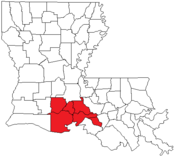 Map of Louisiana highlighting the Lafayette metropolitan area | |||
| Country | |||
| States | |||
| Population (2015) | |||
| • Metro | 490,488 | ||
| Website | http://www.lafayettela.gov/ | ||
| Named for Gilbert du Motier, marquis de La Fayette | |||


The Lafayette Metropolitan Statistical Area is a metropolitan area in the south central Acadiana region of Louisiana that covers five parishes. The five parishes include the original Lafayette and St. Martin parishes as well as Acadia, Iberia and Vermilion parishes, which were added in 2013.[1] As of the 2010 census, the MSA had a population of 273,738. With the three added parishes, a 2015 estimate placed the population at 490,488.[2] It is also part of the larger Lafayette-Acadiana Combined Statistical Area, which had an estimated population of 616,113 in 2013.[2]
Contents
1 Parishes
2 Communities
3 Demographics
4 Politics
5 Economy
6 See also
7 References
Parishes
Acadia Parish - Added in 2013
Iberia Parish - Added in 2013- Lafayette Parish
- St. Martin Parish
Vermilion Parish - Added in 2013
St. Landry Parish, Louisiana
Communities
- Abbeville
Arnaudville (partial)- Breaux Bridge
- Broussard
- Carencro
- Cecilia
Coteau Holmes (unincorporated)- Crowley
- Delcambre
- Duson
- Eunice
- Henderson
- Jeanerette
Lafayette (Principal city)- Loreauville
- Maurice
Milton (unincorporated)
Morgan City (partial)- New Iberia
- Opelousas
- Parks
- Rayne
- St. Martinville
- Scott
- Youngsville
Demographics
As of the census[3] of 2010, there were 273,738, 89,536 households, and 61,826 families residing within the MSA. The racial makeup of the MSA was 71.86% White, 25.46% African American, 0.28% Native American, 1.05% Asian, 0.02% Pacific Islander, 0.45% from other races, and 0.87% from two or more races. Hispanic or Latino of any race were 1.56% of the population.
The median income for a household in the MSA was $33,610, and the median income for a family was $40,737. Males had a median income of $33,565 versus $20,558 for females. The per capita income for the MSA was $16,495.
Politics
The area of Lafayette is politically conservative, however, it does not always vote Republican in elections[citation needed].
Economy
The economy in the Lafayette area is mostly made up of healthcare and associated services, tourism, oil-related businesses, automotive sales, and the restaurant industry.[citation needed]
See also
- Louisiana census statistical areas
- List of cities, towns, and villages in Louisiana
- List of census-designated places in Louisiana
References
^ Bill Lodge (January 15, 2015). "Lafayette, Orleans metros adding parishes; Hammond becomes a metro area". Capital City Press, LLC. Retrieved June 4, 2015..mw-parser-output cite.citation{font-style:inherit}.mw-parser-output q{quotes:"""""""'""'"}.mw-parser-output code.cs1-code{color:inherit;background:inherit;border:inherit;padding:inherit}.mw-parser-output .cs1-lock-free a{background:url("//upload.wikimedia.org/wikipedia/commons/thumb/6/65/Lock-green.svg/9px-Lock-green.svg.png")no-repeat;background-position:right .1em center}.mw-parser-output .cs1-lock-limited a,.mw-parser-output .cs1-lock-registration a{background:url("//upload.wikimedia.org/wikipedia/commons/thumb/d/d6/Lock-gray-alt-2.svg/9px-Lock-gray-alt-2.svg.png")no-repeat;background-position:right .1em center}.mw-parser-output .cs1-lock-subscription a{background:url("//upload.wikimedia.org/wikipedia/commons/thumb/a/aa/Lock-red-alt-2.svg/9px-Lock-red-alt-2.svg.png")no-repeat;background-position:right .1em center}.mw-parser-output .cs1-subscription,.mw-parser-output .cs1-registration{color:#555}.mw-parser-output .cs1-subscription span,.mw-parser-output .cs1-registration span{border-bottom:1px dotted;cursor:help}.mw-parser-output .cs1-hidden-error{display:none;font-size:100%}.mw-parser-output .cs1-visible-error{font-size:100%}.mw-parser-output .cs1-subscription,.mw-parser-output .cs1-registration,.mw-parser-output .cs1-format{font-size:95%}.mw-parser-output .cs1-kern-left,.mw-parser-output .cs1-kern-wl-left{padding-left:0.2em}.mw-parser-output .cs1-kern-right,.mw-parser-output .cs1-kern-wl-right{padding-right:0.2em}
^ ab http://louisiana.gov/Explore/Estimates/
^ "American FactFinder". United States Census Bureau. Retrieved 2008-01-31.
Baton Rouge (capital) | ||
| Topics |
|  Seal of Louisiana |
| Society |
| |
| Regions |
| |
| Cities |
| |
| CDPs |
| |
| Metros |
| |
| Parishes | See: List of parishes in Louisiana | |


