Częstochowa County
Częstochowa County Powiat częstochowski | |||
|---|---|---|---|
County | |||
| |||
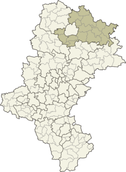 Location within Silesian Voivodeship | |||
| Coordinates (Częstochowa): 50°48′N 19°7′E / 50.800°N 19.117°E / 50.800; 19.117Coordinates: 50°48′N 19°7′E / 50.800°N 19.117°E / 50.800; 19.117 | |||
| Country | |||
| Voivodeship | Silesian | ||
| Seat | Częstochowa | ||
| Gminas | Total 16
| ||
| Area | |||
| • Total | 1,519.49 km2 (586.68 sq mi) | ||
| Population (2006) | |||
| • Total | 133,553 | ||
| • Density | 88/km2 (230/sq mi) | ||
| • Urban | 16,166 | ||
| • Rural | 117,387 | ||
| Car plates | SCZ | ||
| Website | http://www.czestochowa.powiat.pl | ||

Częstochowa County (Polish: powiat częstochowski) is a unit of territorial administration and local government (powiat) in Silesian Voivodeship, southern Poland. It came into being on January 1, 1999, as a result of the Polish local government reforms passed in 1998. Its administrative seat is the city of Częstochowa, although the city is not part of the county (it constitutes a separate city county). The only towns in Częstochowa County are Blachownia, which lies 11 km (7 mi) west of Częstochowa, and Koniecpol, 40 km (25 mi) east of Częstochowa.
The county covers an area of 1,519.49 square kilometres (586.7 sq mi). As of 2006 its total population is 133,553, out of which the population of Blachownia is 9,863, that of Koniecpol is 6,303, and the rural population is 117,387.
Neighbouring counties
Apart from the city of Częstochowa, Częstochowa County is also bordered by Pajęczno County to the north, Radomsko County to the north-east, Włoszczowa County to the east, Zawiercie County and Myszków County to the south, Lubliniec County to the west, and Kłobuck County to the north-west.
Administrative division
The county is subdivided into 16 gminas (two urban-rural and 14 rural). These are listed in the following table, in descending order of population.
Gmina | Type | Area (km²) | Population (2006) | Seat |
Gmina Mykanów | rural | 140.6 | 13,822 | Mykanów |
Gmina Kłomnice | rural | 147.9 | 13,821 | Kłomnice |
Gmina Blachownia | urban-rural | 67.2 | 13,329 | Blachownia |
Gmina Poczesna | rural | 60.1 | 12,490 | Poczesna |
Gmina Konopiska | rural | 78.1 | 10,405 | Konopiska |
Gmina Koniecpol | urban-rural | 146.8 | 10,300 | Koniecpol |
Gmina Mstów | rural | 119.8 | 10,189 | Mstów |
Gmina Rędziny | rural | 41.4 | 9,687 | Rędziny |
Gmina Olsztyn | rural | 108.8 | 6,780 | Olsztyn |
Gmina Janów | rural | 147.0 | 6,019 | Janów |
Gmina Kamienica Polska | rural | 46.7 | 5,634 | Kamienica Polska |
Gmina Lelów | rural | 120.8 | 5,205 | Lelów |
Gmina Kruszyna | rural | 93.4 | 4,899 | Kruszyna |
Gmina Dąbrowa Zielona | rural | 100.3 | 4,125 | Dąbrowa Zielona |
Gmina Przyrów | rural | 80.4 | 4,122 | Przyrów |
Gmina Starcza | rural | 20.1 | 2,726 | Starcza |
References
- Polish official population figures 2006
Częstochowa County | ||
|---|---|---|
| Urban-rural gminas |
|  |
| Rural gminas |
| |
| Seat (not part of the county) |
| |
Counties of Silesian Voivodeship | ||
|---|---|---|
| City counties |
|  |
| Land counties |
| |


