Tombolo
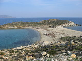
Tombolo near Karystos, Euboea, Greece
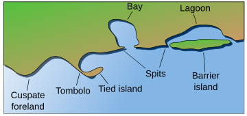
Tombolo contrasted with other coastal landforms.
A tombolo, from the Italian tombolo, derived from the Latin tumulus, meaning 'mound', and sometimes translated as ayre, is a deposition landform in which an island is attached to the mainland by a narrow piece of land such as a spit or bar. Once attached, the island is then known as a tied island. A tombolo is a sandy isthmus.
Several islands tied together by bars which rise above the water level are called a tombolo cluster.[1] Two or more tombolos may form an enclosure (called a lagoon) that can eventually fill with sediment.
Contents
1 Formation
1.1 Wave diffraction and refraction
1.2 Unidirectional longshore drift
2 Morphology and sediment distribution
3 List of tombolos
4 See also
5 References
6 External links
Formation

The tombolo connecting St Ninian's Isle with the Shetland Mainland

Monte Argentario, Tuscany, Italy
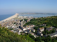
Chesil Beach, seen from the Isle of Portland

The Angel Road of Shōdo Island, Japan

Looking south from the summit of Mount Maunganui, New Zealand, to the city of Tauranga

The eastern end of Bennett Island with its glaciated tombolo in the background
The shoreline moves toward the island (or detached breakwater) due to accretion of sand in the lee of the island where wave energy and longshore drift are reduced and therefore deposition of sand occurs.
Wave diffraction and refraction
True tombolos are formed by wave refraction and diffraction. As waves near an island, they are slowed by the shallow water surrounding it. These waves then bend around the island to the opposite side as they approach. The wave pattern created by this water movement causes a convergence of longshore drift on the opposite side of the island. The beach sediments that are moving by lateral transport on the lee side of the island will accumulate there, conforming to the shape of the wave pattern. In other words, the waves sweep sediment together from both sides. Eventually, when enough sediment has built up, the beach shoreline, known as a spit, will connect with an island and form a tombolo.[2]
Unidirectional longshore drift
In the case of longshore drift from one single or a dominant direction, like at Chesil Beach or Spurn Head, the flow of material is along the coast in a movement which is not determined by the now tied island, such as Portland, which it has reached. In this and similar cases, while the strip of beach material connected to the Island may be technically called a tombolo because it links the island to the land, it is better thought of in terms of its formation – as a spit or otherwise.
Morphology and sediment distribution
Tombolos are more prone to natural fluctuations of profile and area as a result of tidal and weather events than a normal beach is. Because of this susceptibility to weathering, tombolos are sometimes made more sturdy through the construction of roads or parking lots. The sediments that make up a tombolo are coarser towards the bottom and finer towards the surface. It is easy to see this pattern when the waves are destructive and wash away finer grained material at the top, revealing coarser sands and cobbles as the base.
Sea level rise may also contribute to accretion, as material is pushed up with rising sea levels. This is the case with Chesil Beach (which connects the Isle of Portland to Dorset in England), notable because the shingle ridge is parallel rather than at right angles to the coast.
Tombolos demonstrate the sensitivity of shorelines. A small piece of land, such as an island, can change the way that waves move, leading to different deposition of sediments.
List of tombolos
Adam's Bridge (until 1480), between India and Sri Lanka
- The Angel Road of Shodo Island, Japan
Aupouri Peninsula, New Zealand
Barrenjoey Headland, Pittwater, New South Wales, Australia
Beavertail Point, Conanicut Island, Rhode Island
Bennett Island, De Long Group
Biddeford Pool, Maine[3]
Bruny Island, Tasmania
Cádiz, Andalucía, Spain
Chappaquiddick Island, Martha's Vineyard, Massachusetts
Charles Island, Connecticut
Chesil Beach, Portland, Dorset
Cheung Chau, Hong Kong
Crimea, Ukraine
Eaglehawk Neck, Tasmania, Australia
S'Espalmador, Formentera, Spain
Fingal Bay, New South Wales, Australia
- The Rock of Gibraltar
Grand Island National Recreation Area, Michigan, Lake Superior
Gugh, St Agnes, Isles of Scilly, England
Gwadar, Pakistan
Hakodate, Hokkaido, Japan
Howth Head, Dublin, Ireland
Inishkeel Island, Narin, Ireland
Kapıdağ Peninsula, Balıkesir, Turkey
Kurnell, Sydney, New South Wales, Australia
Langness, Derbyhaven, Isle of Man
Las Palmas de Gran Canaria, Canary Islands, Spain
Louds Island at Muscongus Bay, Maine
Maharees, Dingle Peninsula, Ireland
Mare Island, Vallejo, California
Maria Island, Tasmania
Miquelon, Saint-Pierre and Miquelon, France
Monemvasia, Laconia, Peloponnese, Greece
Monte Argentario, Tuscany, Italy
Mount Maunganui, New Zealand
Mount Taipingot, Rota, Northern Marianas
Nahant, Massachusetts (a natural tombolo, but connected to the mainland by a causeway)
Nissi beach, Ayia Napa, Cyprus
Palisadoes, Kingston, Jamaica
Peniche, Portugal
Peniscola, Castellon, Spain
Presqu'ile Provincial Park, Ontario, Canada
Presqu'ile de Giens, Hyères, France
Quiberon, France
Sainte-Marie, Martinique, France
Shaman's Island, Douglas, Alaska
Sharp Island, Sai Kung, Hong Kong
Silver Strand (San Diego), Coronado, California
St Ninian's Isle, Shetland Islands, Scotland
Scotts Head, Dominica
Uummannaq in North Star Bay, Greenland
Yei of Huney, Huney, Shetland Islands, Scotland
Zhifu Island, Yantai, Zhifu Island, China
Pulau Konet, Masjid Tanah, Melaka, Malaysia- Knappelskär, Nynäshamn, Sweden
See also
- Ayre (landform)
- Bar
- Cuspate Foreland
- Isthmus
- Tied island
- Shoal
Tombolo Company*
References
^ Glossary of Geology and Related Sciences. The American Geological Institute, 1957
^ Easterbrook, Don T. Surface Processes and Landforms, Second Edition. 1999 Prentice Hall Inc.
^ Neal, William; Orrin H. Pilkey; Joseph T. Kelley (2007). Atlantic Coast Beaches: A Guide to Ripples, Dunes, and Other Natural Features of the Seashore. Missoula, MT: Mountain Press Publishing Company. p. 272. ISBN 0-87842-534-9..mw-parser-output cite.citation{font-style:inherit}.mw-parser-output q{quotes:"""""""'""'"}.mw-parser-output code.cs1-code{color:inherit;background:inherit;border:inherit;padding:inherit}.mw-parser-output .cs1-lock-free a{background:url("//upload.wikimedia.org/wikipedia/commons/thumb/6/65/Lock-green.svg/9px-Lock-green.svg.png")no-repeat;background-position:right .1em center}.mw-parser-output .cs1-lock-limited a,.mw-parser-output .cs1-lock-registration a{background:url("//upload.wikimedia.org/wikipedia/commons/thumb/d/d6/Lock-gray-alt-2.svg/9px-Lock-gray-alt-2.svg.png")no-repeat;background-position:right .1em center}.mw-parser-output .cs1-lock-subscription a{background:url("//upload.wikimedia.org/wikipedia/commons/thumb/a/aa/Lock-red-alt-2.svg/9px-Lock-red-alt-2.svg.png")no-repeat;background-position:right .1em center}.mw-parser-output .cs1-subscription,.mw-parser-output .cs1-registration{color:#555}.mw-parser-output .cs1-subscription span,.mw-parser-output .cs1-registration span{border-bottom:1px dotted;cursor:help}.mw-parser-output .cs1-hidden-error{display:none;font-size:100%}.mw-parser-output .cs1-visible-error{font-size:100%}.mw-parser-output .cs1-subscription,.mw-parser-output .cs1-registration,.mw-parser-output .cs1-format{font-size:95%}.mw-parser-output .cs1-kern-left,.mw-parser-output .cs1-kern-wl-left{padding-left:0.2em}.mw-parser-output .cs1-kern-right,.mw-parser-output .cs1-kern-wl-right{padding-right:0.2em}
External links
| Wikimedia Commons has media related to Tombolos. |
Geology.About.com's page on tombolos (useful for its descriptive photograph)
Tombolo in Sainte-Marie, Martinique (useful for its photos and description)- further reading on Detached breakwaters fom Vlaams Instituut voor de Zee in Belgium
- further reading on coastal structures fom Prof. Leo van Rijn in Holland
Coastal geography | ||
|---|---|---|
| Landforms |
|   |
| Beaches |
| |
| Processes |
| |
| Management |
| |
| Related |
| |
| ||


