伊德利卜省
body.skin-minerva .mw-parser-output table.infobox caption{text-align:center}
伊德利卜省 مُحافظة ادلب | |
|---|---|
省 | |
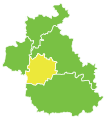
 伊德利卜省在敘利亞的位置 | |
坐标:35°47′N 36°41′E / 35.78°N 36.69°E / 35.78; 36.69 | |
| 國家 | |
| 首府 | 伊德利卜 |
| 區 | 5 |
| 面积 | |
| • 总计 | 6,097 平方公里(2,354 平方英里) |
估計為5,933~6,097平方公里 | |
| 人口(2011年) | |
| • 總計 | 1,501,000 |
| • 密度 | 246/平方公里(640/平方英里) |
| 时区 | 欧洲东部时间 (UTC+2) |
| • 夏时制 | 欧洲东部夏令时间(UTC+3) |
伊德利卜省(阿拉伯语:مُحافظة ادلب)是敘利亞西北部的一個省,北鄰土耳其哈塔伊省。西邊為拉塔基亞省,東邊為阿勒頗省,南邊為哈馬省。西部有阿西河。首府伊德利卜,大部分土地是丘陵和山地,中為一個肥沃的盆地地帶。該省分為五個區,埃里哈區,哈利姆區,伊德利卜區,吉斯爾舒古爾區,邁阿賴努阿曼區。面積6,097平方公里,2012年估計人口1.852.062人,人口密度為303.8人/平方公里。主要農作物包括棉花,穀物,橄欖,無花果,葡萄,蕃茄,芝麻和杏仁。當地工業包括紡織和壓榨橄欖油。

邁阿賴努阿曼區(人口為371,829人,2004年的人口普查。)

吉斯爾舒古爾區(人口為150,193人。)

伊德利卜區(人口為384,929人。)

哈利姆區(人口為175,482人。)
埃里哈區(人口為175,994人。)


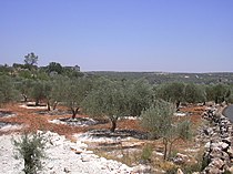
伊德利卜橄欖樹林

城鎮區的橄欖樹林
| ||||||||


