Tokat Province
Tokat Province Tokat ili | |
|---|---|
Province of Turkey | |
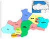
 Location of Tokat Province in Turkey | |
| Country | Turkey |
| Region | West Black Sea |
| Subregion | Samsun |
| Government | |
| • Electoral district | Tokat |
| Area | |
| • Total | 9,959 km2 (3,845 sq mi) |
| Population (2010)[1] | |
| • Total | 602,662 |
| • Density | 61/km2 (160/sq mi) |
| Area code(s) | 0356 |
| Vehicle registration | 60 |
Tokat Province (Turkish: Tokat ili) is a province in northern Turkey. Its adjacent provinces are Amasya to the northwest, Yozgat to the southwest, Sivas to the southeast, and Ordu to the northeast. Its capital is Tokat, which lies inland of the middle Black Sea region, 422 kilometers from Ankara.
Contents
1 History
2 Districts
3 Landmarks
4 Climate
5 Gallery
6 References
7 External links
History
Tokat is the site of the important ancient Roman city of Comana of Pontus, which was destroyed in 47 BCE by the Romans. In 1071 CE, it became a part of the Danismend Turkmen principality, and one of its principal cities. The region prospered from the trade between Anatolia and Persia.
Districts
Tokat province is divided into 12 districts (capital district in bold):
- Almus
- Artova
- Başçiftlik
- Erbaa
- Niksar
- Pazar
- Reşadiye
- Sulusaray
- Tokat
- Turhal
- Yeşilyurt
- Zile
Landmarks
Two notable monuments in this province are the Hatuniye Medrese of the 15th century, built by Sultan Bayezid II, and a Seljuk bridge spanning the Yeşilırmak River, belonging to the 12th century. The Latifoğlu Mansion is a third, which is an example of the traditional architecture of a Turkish house of the 19th century, restored recently to its original state.
Climate
| Months | January | February | March | April | May | June | July | August | September | October | November | December | |
|---|---|---|---|---|---|---|---|---|---|---|---|---|---|
| Average Maximum °C (1970 - 2011) | 20.2 | 22.8 | 31.1 | 33.5 | 36.1 | 38.5 | 45.0 | 40.8 | 37.9 | 35.3 | 27.6 | 23.0 | |
| Average Lowest °C (1970 - 2011) | -23.4 | -22.1 | -21.1 | -4.5 | 0.0 | 3.2 | 6.1 | 7.8 | 2.4 | -3.2 | -8.3 | -21.0 | |
| Resource: Turkish State Meteorological Service[2] | |||||||||||||
Gallery
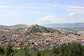
Tokat

Gök Medrese in Tokat

Polychrome tiles from Gök Medrese
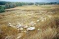
Maşat Höyük, a Hittite archaeological site

Atatürk's House Museum

Tokat Mevlevihanesi


References
^ Turkish Statistical Institute, MS Excel document – Population of province/district centers and towns/villages and population growth rate by provinces
^ Meteoroloji Genel Müdürlüğü-Tokat Resmi İstatistikler, Turkish State Meteorological Service
External links
| Wikimedia Commons has media related to Tokat Province. |
(in Turkish) Tokat governor's official website
(in Turkish) Tokat municipality's official website
(in English) Tokat weather forecast information
- Pictures of the capital of Tokat province, with links to others nearby
Tokat Province of Turkey | |||||||||||||||||||||||||||
|---|---|---|---|---|---|---|---|---|---|---|---|---|---|---|---|---|---|---|---|---|---|---|---|---|---|---|---|
| Districts |
|  | |||||||||||||||||||||||||
||
Metropolitan municipalities are bolded. | |||||||||||||||||||||||||||
| ||
Metropolitan municipalities are bolded. | ||
Coordinates: 40°21′10″N 36°33′52″E / 40.35278°N 36.56444°E / 40.35278; 36.56444


