Seward, Alaska
Seward, Alaska | |||
|---|---|---|---|
City | |||
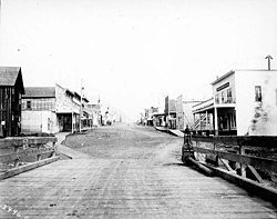 Fourth Avenue, August 1907 | |||
| |||
| Nickname(s): "Gateway to the Kenai Fjords" | |||
| Motto(s): "Alaska Starts Here" | |||
 Seward, Alaska Location in Alaska | |||
| Coordinates: 60°07′28″N 149°26′00″W / 60.12444°N 149.43333°W / 60.12444; -149.43333Coordinates: 60°07′28″N 149°26′00″W / 60.12444°N 149.43333°W / 60.12444; -149.43333 | |||
| Country | United States | ||
| State | Alaska | ||
| Borough | Kenai Peninsula | ||
| Established | 1903 | ||
| Incorporated | June 1, 1912[1] | ||
| Government | |||
| • Type | Council-manager | ||
| • Mayor | David Squires[2] | ||
| • State senator | Peter Micciche (R) | ||
| • State rep. | Mike Chenault (R) | ||
| Area [3] | |||
| • Total | 21.55 sq mi (55.82 km2) | ||
| • Land | 14.11 sq mi (36.55 km2) | ||
| • Water | 7.44 sq mi (19.27 km2) | ||
| Elevation | 0 ft (0 m) | ||
| Population (2010) | |||
| • Total | 2,693 | ||
| • Estimate (2017)[4] | 2,831 | ||
| • Density | 129.31/sq mi (49.93/km2) | ||
| Time zone | UTC−9 (Alaska) | ||
| • Summer (DST) | UTC−8 (Alaska) | ||
| ZIP code | 99664 | ||
| Area code | 907 | ||
| FIPS code | 02-68560 | ||
GNIS feature ID | 1414598 | ||
| Website | City of Seward Website | ||
| Source of coordinates [5] | |||


Seward (Alutiiq: Qutalleq) is an incorporated home rule city in Alaska, United States. Located on Resurrection Bay, a fjord of the Gulf of Alaska on the Kenai Peninsula, Seward is situated on Alaska's southern coast, approximately 120 miles by road from Alaska's largest city, Anchorage, and nearly 1,300 miles from the closest point in the contiguous United States at Cape Flattery, Washington.
With an estimated permanent population of 2,831 people as of 2017,[6] Seward is the fourth-largest city in the Kenai Peninsula Borough, behind Kenai, Homer, and the borough seat of Soldotna. The city is named for former U.S. Secretary of State William H. Seward, who orchestrated the United States' purchase of Alaska from the Russian Empire in 1867 while serving in this position as part of President Andrew Johnson's administration.
Seward is the southern terminus of the Alaska Railroad and the historic starting point of the original Iditarod Trail to the Alaskan interior, with Mile 0 of the trail marked on the shoreline at the southern end of town.
Contents
1 History
2 Geography
2.1 Climate
3 Economy
3.1 Fishing
3.2 Tourism
4 Demographics
5 Government and infrastructure
6 Education
7 Transportation
8 International sister cities
9 Notable people
10 Attractions and points of interest
11 References
12 External links
History
In 1793 Alexander Baranov of the Shelikhov-Golikov company (precursor of the Russian-American Company) established a fur trade post on Resurrection Bay where Seward is today, and had a three-masted vessel, the Phoenix, built at the post by James Shields, an English shipwright in Russian service.[7]
The 1939 Slattery Report on Alaskan development identified the region as one of the areas where new settlements would be established through Jewish immigration.[citation needed] This plan was never implemented.
Seward was an important port for the military buildup in Alaska during World War II. Fort Raymond was established in Seward along the Resurrection River to protect the community. An Army airfield built in Seward during the war later became Walseth Air Force Base. Both of the military facilities were closed shortly after the end of the war.[8]
A large portion of Seward was damaged by shaking and a local tsunami during the 1964 Alaska earthquake.[9]
Geography

Aerial view of Seward, Alaska in the 1990s, looking north. The mouth of the Resurrection River and the base of Mount Marathon are visible.
According to the United States Census Bureau, the city has a total area of 21.5 square miles (56 km2), of which 14.4 square miles (37 km2) is land and 7.1 square miles (18 km2) (32.93%) is water.
The northern city limits are demarcated by the lower reaches of the Resurrection River, but extend east past the river's mouth at the northern end of Resurrection Bay to include parts of the bay's extreme northeastern shore, including the beach at the mouth of Fourth of July Creek and the grounds of Spring Creek Correctional Center just inland. To the south, the city limits extend to the unincorporated community of Lowell Point, while the east and west sides of the city are constrained by Resurrection Bay and the steep slopes of Mount Marathon.
Nearby settlements include the aforementioned Lowell Point to the south, as well as the census-designated places of Bear Creek and Moose Pass further north. The nearest incorporated city is Soldatna, about 90 miles away by road to the northwest.
Climate
By definition, Seward has a subarctic climate (Köppen Dfc), but it experiences relatively moderate temperatures compared to the rest of the state throughout the year due to the influence of the nearby Gulf of Alaska. Only one month, January, sees an average daily high temperature below freezing, and temperatures below zero degrees Fahrenheit are rare. The oceanic influence also imparts a high level of precipitation, with the heaviest amounts occurring during the fall and winter months.
| Climate data for Seward Airport (1981−2010 normals) | |||||||||||||
|---|---|---|---|---|---|---|---|---|---|---|---|---|---|
| Month | Jan | Feb | Mar | Apr | May | Jun | Jul | Aug | Sep | Oct | Nov | Dec | Year |
| Average high °F (°C) | 31.8 (−0.1) | 33.4 (0.8) | 37.8 (3.2) | 44.8 (7.1) | 53.0 (11.7) | 58.3 (14.6) | 61.3 (16.3) | 61.5 (16.4) | 55.2 (12.9) | 44.5 (6.9) | 35.4 (1.9) | 33.6 (0.9) | 45.9 (7.7) |
| Daily mean °F (°C) | 27.1 (−2.7) | 28.3 (−2.1) | 32.1 (0.1) | 38.7 (3.7) | 46.4 (8) | 52.2 (11.2) | 56.0 (13.3) | 55.7 (13.2) | 49.5 (9.7) | 39.6 (4.2) | 30.9 (−0.6) | 28.9 (−1.7) | 40.6 (4.8) |
| Average low °F (°C) | 22.3 (−5.4) | 23.2 (−4.9) | 26.4 (−3.1) | 32.5 (0.3) | 39.9 (4.4) | 46.1 (7.8) | 50.7 (10.4) | 50.0 (10) | 43.8 (6.6) | 34.7 (1.5) | 26.4 (−3.1) | 24.2 (−4.3) | 35.0 (1.7) |
| Average precipitation inches (mm) | 8.07 (205) | 6.05 (154) | 4.42 (112) | 4.52 (115) | 3.37 (86) | 2.42 (61) | 2.80 (71) | 5.61 (142) | 9.86 (250) | 9.35 (237) | 7.31 (186) | 9.54 (242) | 73.32 (1,861) |
| Average snowfall inches (cm) | 12.9 (33) | 12.6 (32) | 10.5 (27) | 3.7 (9) | .3 (1) | 0 (0) | 0 (0) | 0 (0) | 0 (0) | .5 (1) | 8.2 (21) | 15.7 (40) | 64.4 (164) |
| Average precipitation days (≥ 0.01 in) | 15.1 | 13.7 | 13.1 | 13.7 | 13.5 | 11.6 | 12.5 | 14.1 | 16.9 | 16.5 | 14.3 | 16.6 | 171.6 |
| Average snowy days (≥ 0.1 in) | 5.8 | 5.0 | 4.7 | 2.2 | .1 | 0 | 0 | 0 | 0 | .8 | 3.9 | 6.7 | 29.2 |
| Source: NOAA[10] | |||||||||||||
Economy
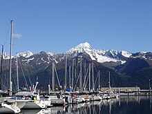
Boats in the harbor, with the snow-capped peak of Mount Alice across the bay to the east in the background.
Seward's local economy is largely driven by the commercial fishing industry and seasonal tourism. Many lodging facilities, restaurants and shops in the city cater mainly to tourists, and are only open for business during the summer tourist season, generally regarded as running from mid-May through mid-September. Other major employers in the city include the state-run Spring Creek Correctional Center, the Alaska Department of Labor and Workforce Development's AVTEC vocational school, and the local Providence Health & Services branch, which also serves as the community's main medical center.
Fishing
Seward is among the most lucrative commercial fisheries ports in the United States, according to reports from the National Marine Fisheries Service. Per the most recent yearly data available, for 2016, commercial fishing boats in Seward offloaded approximately 13,500 tons of fish and shellfish, valued at about $42 million USD.[11] Over the course of the decade from 2007 to 2016, around $545 million USD in commercial seafood passed through Seward's harbor.
Tourism
Owing to its position at the southern terminus of the Alaska Railroad and well-developed road links to Anchorage and the rest of the Kenai Peninsula, Seward is both a major northern end-port for several major cruise ship lines that host Alaskan cruises, such as Norwegian, Royal Caribbean, Holland America, and Celebrity Cruises,[12] and a common destination for general Alaskan tourism.
- Seward also has a minor military installation and is the home port of the USCGC Mustang.
Demographics
| Historical population | |||
|---|---|---|---|
| Census | Pop. | %± | |
| 1910 | 534 | — | |
| 1920 | 652 | 22.1% | |
| 1930 | 835 | 28.1% | |
| 1940 | 949 | 13.7% | |
| 1950 | 2,114 | 122.8% | |
| 1960 | 1,891 | −10.5% | |
| 1970 | 1,587 | −16.1% | |
| 1980 | 1,843 | 16.1% | |
| 1990 | 2,699 | 46.4% | |
| 2000 | 2,830 | 4.9% | |
| 2010 | 2,693 | −4.8% | |
| Est. 2016 | 2,787 | [4] | 3.5% |
| U.S. Decennial Census[13] | |||
Seward first appeared on the 1910 U.S. Census as an unincorporated village. It formally incorporated in 1912.
As of the census[14] of 2000, there were 2,830 people, 917 households, and 555 families residing in the city. The population density was 196.0 people per square mile (75.7/km²). There were 1,058 housing units at an average density of 73.3 per square mile (28.3/km²). The racial makeup of the city was 72.12% White, 2.44% Black or African American, 16.68% Native American, 1.84% Asian, 0.18% Pacific Islander, 0.88% from other races, and 5.87% from two or more races. 2.40% of the population were Hispanic or Latino of any race.
There were 917 households out of which 35.7% had children under the age of 18 living with them, 44.6% were married couples living together, 12.1% had a female householder with no husband present, and 39.4% were non-families. 30.8% of all households were made up of individuals and 7.1% had someone living alone who was 65 years of age or older. The average household size was 2.40 and the average family size was 3.04.
In the city, the age distribution of the population shows 21.9% under the age of 18, 9.0% from 18 to 24, 35.9% from 25 to 44, 25.7% from 45 to 64, and 7.5% who were 65 years of age or older. The median age was 37 years. For every 100 females, there were 150.2 males. For every 100 females age 18 and over, there were 166.6 males.
The median income for a household in the city was $44,306, and the median income for a family was $54,904. Males had a median income of $36,900 versus $30,508 for females. The per capita income for the city was $20,360. About 8.3% of families and 10.6% of the population were below the poverty line, including 12.7% of those under age 18 and 7.9% of those age 65 or over.
Government and infrastructure
This article may require cleanup to meet Wikipedia's quality standards. The specific problem is: For starters, this article is about Seward, the city, which has its own government. The following section is merely a series of random statements designed solely to provide links. In other words, we're offering readers the equivalent of clickbait in lieu of offering them real information. Providing a link to a City of Seward document but otherwise not acknowledging the city government in this section? Please. (September 2016) (Learn how and when to remove this template message) |
The City of Seward employs a council–manager style of government, with a seven-member city council elected by the citizens, as well as a council-appointed city manager, city attorney and city clerk, responsible for all local administration including police, fire, utilities, and harbor management.[15] At the borough level, Seward is situated in Kenai Peninsula Borough District 6,[16] which has one seat on the nine-member borough council. This council oversees area-wide issues such as education, waste management, zoning and taxation assessment.

Spring Creek Correctional Center
The United States Postal Service maintains a post office in Seward with zip code 99664.
In the Alaska House of Representatives, the city is in the 29th District, represented by Republican Mike Chenault.
In the Alaska Senate, the city is in District O, represented by Republican Peter Micciche.
Education
The Kenai Peninsula Borough School District operates schools in Seward. Seward Elementary School, Seward Middle School, and Seward High School serve Seward.[17]
Transportation

A northbound Alaska Railroad passenger train idles at the Seward depot on June 30, 2010. Race Point on Mount Marathon is the high point on the right-hand side.
Seward is unusual among most small Alaskan communities in that it has road access in the Seward Highway from Seward to Anchorage, a National Scenic Byway and All-American Road, which also brings it bus service. Seward is also the southern terminus of the Alaska Railroad with the railroad serving the Port of Seward which is capable of accommodating ocean going vessels. This keeps the port busy with freight coming on and off the trains, but also makes Seward a primary end point for north-bound cruise ships. Cruise ship passengers disembark and often take the train or bus farther north to Anchorage, Denali, or other Alaskan attractions. The Alaska Railroad operates passenger service into Seward on a seasonal basis via the
Coastal Classic train.
Seward is a very bike friendly community. A paved bike path runs from the downtown business district along the waterfront, through the harbor and along the highway to mile 4.5. Bikes are available for rent and there are guided bike tours of the area.
Alaska Marine Highway (ferry) service was discontinued at the end of the 2005. State ferry connections are now available in Whittier (90 miles North) or Homer (150 miles by highway).
Seward Airport (PAWD/SWD) is home to general aviation services and flight-seeing operators. Scheduled commercial service is available at Kenai Municipal Airport in Kenai and Ted Stevens Anchorage International Airport, both about 100 miles (160 km) away. Bus connections are also available.
International sister cities
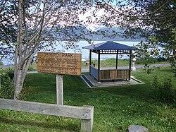
Obihiro Park, with gazebo given to the people of Seward in 1993. Resurrection Bay is in the background.
 Obihiro, Hokkaido, Japan (1968)
Kushiro, Hokkaido, Japan (1982)
 Yeosu, South Korea (informal) [18]
Notable people

Benny Benson Memorial at Milepost 1.4 of the Seward Highway in Seward, Alaska
Benny Benson, Native Alaskan and designer of what would become the Alaskan state flag.
Harry Kawabe, Japanese-American businessman sent to internment camp during World War II
Attractions and points of interest

Seward, Alaska, 1959
Mount Marathon and its famous Mount Marathon Race
Kenai Fjords National Park with its easily accessible Exit Glacier
- Alaska SeaLife Center
- Seward Silver Salmon Derby
- Seward Polar Bear Jump-Off
- Seward Spring Break Up Festival
Seward Music and Arts Festival, every year in September
Balto Film Fest, last weekend of July- The ruins of the Jesse Lee Home for Children
References
^ 1996 Alaska Municipal Officials Directory. Juneau: Alaska Municipal League/Alaska Department of Community and Regional Affairs. January 1996. p. 138..mw-parser-output cite.citation{font-style:inherit}.mw-parser-output q{quotes:"""""""'""'"}.mw-parser-output code.cs1-code{color:inherit;background:inherit;border:inherit;padding:inherit}.mw-parser-output .cs1-lock-free a{background:url("//upload.wikimedia.org/wikipedia/commons/thumb/6/65/Lock-green.svg/9px-Lock-green.svg.png")no-repeat;background-position:right .1em center}.mw-parser-output .cs1-lock-limited a,.mw-parser-output .cs1-lock-registration a{background:url("//upload.wikimedia.org/wikipedia/commons/thumb/d/d6/Lock-gray-alt-2.svg/9px-Lock-gray-alt-2.svg.png")no-repeat;background-position:right .1em center}.mw-parser-output .cs1-lock-subscription a{background:url("//upload.wikimedia.org/wikipedia/commons/thumb/a/aa/Lock-red-alt-2.svg/9px-Lock-red-alt-2.svg.png")no-repeat;background-position:right .1em center}.mw-parser-output .cs1-subscription,.mw-parser-output .cs1-registration{color:#555}.mw-parser-output .cs1-subscription span,.mw-parser-output .cs1-registration span{border-bottom:1px dotted;cursor:help}.mw-parser-output .cs1-hidden-error{display:none;font-size:100%}.mw-parser-output .cs1-visible-error{font-size:100%}.mw-parser-output .cs1-subscription,.mw-parser-output .cs1-registration,.mw-parser-output .cs1-format{font-size:95%}.mw-parser-output .cs1-kern-left,.mw-parser-output .cs1-kern-wl-left{padding-left:0.2em}.mw-parser-output .cs1-kern-right,.mw-parser-output .cs1-kern-wl-right{padding-right:0.2em}
^ Template:Http://www.cityofseward.us/index.aspx?nid=295
^ "2016 U.S. Gazetteer Files". United States Census Bureau. Retrieved Jun 22, 2017.
^ ab "Population and Housing Unit Estimates". Retrieved June 9, 2017.
^ "US Gazetteer files: 2010, 2000, and 1990". United States Census Bureau. 2011-02-12. Retrieved 2011-04-23.
^ Bureau, U.S. Census. "American FactFinder - Community Facts". factfinder.census.gov. Retrieved 2018-09-20.
^ Haycox, Stephen W. (2002). Alaska: An American Colony. University of Washington Press. p. 82. ISBN 978-0-295-98249-6.
^ "Veteran recalls WWII duty in remote Alaska outpost". www.adn.com. Retrieved 2017-06-30.
^ "Effects of the 1964 Tsunami on Seward Alaska". www.usc.edu. Archived from the original on 2001-01-24. Retrieved 2016-05-28.
^ "Station Name: AK SEWARD AP". National Oceanic and Atmospheric Administration. Retrieved 2013-07-05.
^ "Total Commercial Fishery Landings At Major U. S. Ports Summarized By Year and Ranked By Dollar Value". www.st.nmfs.noaa.gov. Retrieved 2018-09-20.
^ "Seward, Alaska Cruise Ship Schedule 2018 | Crew Center". crew-center.com. Retrieved 2018-09-20.
^ "Census of Population and Housing". Census.gov. Retrieved June 4, 2015.
^ "American FactFinder". United States Census Bureau. Retrieved 2008-01-31.
^ "Seward, AK - Official Website - About our Government". www.cityofseward.us. Retrieved 2018-09-20.
^ Kenai Peninsula Borough (2012). "District6_Redistrict_2012.pdf" (PDF). https://www.kpb.us/assembly-clerk/meet-the-assembly. Retrieved 2018-09-20. External link in|website=(help)
^ "Attendance Area Boundaries." Kenai Peninsula Borough School District. Retrieved on September 27, 2010.
^ "Seward, AK - Official Website - Sister City Program". www.cityofseward.us. Retrieved 2018-09-20.
External links
| Wikimedia Commons has media related to Seward, Alaska. |
 Seward travel guide from Wikivoyage
- City of Seward in Alaska
- Seward Chamber of Commerce and Conference & Visitors Bureau
The Seward Phoenix LOG, weekly newspaper serving the Eastern Kenai Peninsula since 1966
SewardCityNews.com Seward's citizen journalism site
Seward, Alaska at Curlie
Municipalities and communities of Kenai Peninsula Borough, Alaska, United States | ||
|---|---|---|
Borough seat: Soldotna | ||
| Cities |
|  |
| CDPs |
| |
| Unincorporated communities |
| |
Authority control |
|
|---|


