歐卡托撞擊坑
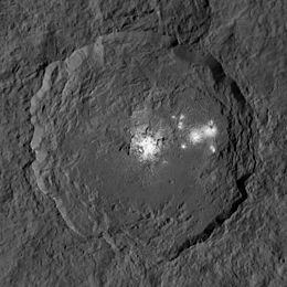 曙光號太空船拍攝的歐卡托撞擊坑黑白影像。 | |
| 位置 | 穀神星 |
|---|---|
| 座標 | 19°52′N 238°51′E / 19.86°N 238.85°E / 19.86; 238.85[1][2]坐标:19°52′N 238°51′E / 19.86°N 238.85°E / 19.86; 238.85[1][2] |
| 直徑 | 92公里(57英里) |
| 深度 | 4 km |
| 發現者 | 曙光號太空船團隊 2015 |
| 名稱 | 歐卡托,刻瑞斯的助手 |
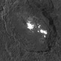
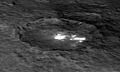
歐卡托撞擊坑(Occator,/ɒˈkeɪtər/)是一個位於矮行星穀神星表面的撞擊坑,其引人注目之處在於,它是“亮斑5”(黎明號所觀測到穀神星表面最亮的反照率特徵)的所在地點。在早期凱克天文台觀測影像中就已經發現到它的存在,並被標記為“A區”[3]。
該撞擊坑以羅馬神話中代表農具耖的神明,也是農業與穀物之神刻瑞斯的助手歐卡托命名[1][2]。
科學家於2015年7月宣布黎明號在亮斑上方發現了煙霧[4],而且不止一次觀測到這種現象。這表明穀神星上某個地區可以維持氣體的存在,甚至可能是穀神星大氣的基礎。煙霧停留在亮斑附近,撞擊坑的大半個區域都被煙霧覆蓋,大大提升了亮斑由冰構成的可能性。這團煙霧極有可能是亮斑中的冰體昇華所形成,也提升了某種冰火山活動正在進行的推測。
但在12月9日,科學家宣稱穀神星表面,包括歐卡托撞擊坑中“亮斑5”的亮斑可能與某種鹽有關.。它們可能是包含了硫酸鎂的鹽滷;這些斑點也被發現與富含氨的粘土相關[5]。
影像

以假色代表高程的地形圖
(2015年12月)
斜視圖
(2015年12月)

側視圖
(2015年12月)

假色
(2015年12月)
類3D視角
(2015年12月)

撞擊坑環西緣近距離影像
(2016年1月)


參見
- 穀神星表面特徵列表
- 穀神星地質
參考資料
^ 1.01.1 Staff. Planetary Names: Crater, craters: Occator on Ceres. USGS. 6 July 2015 [16 July 2015].
^ 2.02.1 Staff. USGS: Ceres nomenclature (PDF). USGS. 13 July 2015 [16 July 2015].
^ Kupper; 等. PIA17831: Water Detection on Ceres. NASA. 22 January 2014 [30 July 2015].
^ [1]
^ Landau, Elizabeth. New Clues to Ceres' Bright Spots and Origins. NASA. 9 December 2015 [10 December 2015].
| ||||||||||||||||||||||||


