丹帕沙
body.skin-minerva .mw-parser-output table.infobox caption{text-align:center}
| 登巴薩市 Denpasar | ||
|---|---|---|
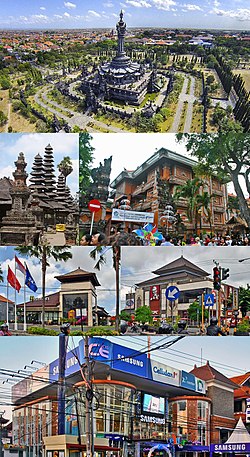 从上到下,从左到右依次为 Bajra Sandhi纪念碑、巴厘式寺庙、市场办公室大楼、巴厘式建筑的快餐店、手机店。 | ||
| ||
 在巴厘省的位置 | ||
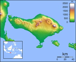 登巴薩市 Denpasar 在印度尼西亚小巽他群岛巴厘省的位置 Show map of Indonesia Bali  登巴薩市 Denpasar 在印度尼西亚小巽他群岛巴厘省的位置 Show map of Lesser Sunda Islands  登巴薩市 Denpasar 在印度尼西亚小巽他群岛巴厘省的位置 Show map of 印度尼西亞 | ||
坐标:8°39′S 115°13′E / 8.650°S 115.217°E / -8.650; 115.217坐标:8°39′S 115°13′E / 8.650°S 115.217°E / -8.650; 115.217 | ||
| 國家 | ||
| 省 | 巴厘省 | |
| 面积 | ||
| • 总计 | 123.98 平方公里(47.87 平方英里) | |
| 海拔 | 4 米(13 英尺) | |
| 人口(2017) | ||
| • 總計 | 897,300 | |
| 时区 | WITA (UTC+8) | |
| 網站 | www.denpasarkota.go.id | |

丹帕沙市(Kota Denpasar),舊名巴東(Badung),是印尼峇里島最大城市。它除了是峇里省下轄九個次級行政區中唯一一個「市」(Kota)級次行政區之外,也是峇里省首府,位於該島中央偏南位置,人口約79萬。
目录
1 歷史
2 交通
3 主要觀光點
4 參考
5 外部連結
歷史
「Denpasar」這名稱源自「den pasar」,在荷蘭語中是「市場」之意。舊時此地是島上主要市集與商業重鎮。19世紀中葉荷蘭人在巴東地區殖民,當地各部落酋長選擇與殖民者妥協合作,以換取安定的局勢。但由於各酋長與荷蘭人因海難事件處理不當,引起衝突,荷蘭部隊在1906年登島進攻巴東,當地居民除了在砲火中犧牲外,很多峇里人包括部族領袖在內,則選擇在一種叫「浦浦壇」(Puputan,意指「奮戰至死」或「結束」)的自殺儀式中結束生命,估計死亡人數約在600至2000人之間。其後荷蘭人繼續進攻周邊地區,整個峇里島王朝遂在1908年滅亡。
1949年巴東成為峇里省首府,並於1992年獨立設市,規劃裡市區部分更名為「丹帕沙」,其餘部分則仍沿用原本巴東區(Kabupaten Badung)的舊名。由於近年印尼政府積極開發南邊的庫塔(Kuta)地區,使丹帕沙的觀光產業逐漸沒落,但由於該市位於全島南北之間的主要動線上,因此仍有其行政與交通中樞的重要性。
交通

丹帕沙街道一景。
伍拉·賴國際機場(Ngurah Rai Airport,WADD/DPS)又名「峇里國際機場」,是丹帕沙與整個峇里島的主要國際機場,位於該市南方約13公里處。僅次於雅加達的蘇加諾-哈達國際機場(Soekarno-Hatta International Airport)和泗水的朱安達國際機場,是印尼國內運量排名第三的主要機場。由於峇里島地處亞洲及大洋洲的交界,因此該機場亦是往返兩地區的航線一個重要的轉機地點。
主要觀光點
浦浦壇廣場(Taman Puputan)- 峇里博物館
巴東市場(Pasar Badung)
昆巴沙利市場(Pasar Kumbasari)
參考
- 《峇里島》(Discovery Channel知性之旅系列),協和國際多媒體(台北,台灣),ISBN 957-2080-26-1
(繁体中文)遠東航空官方網站峇里島簡介頁面
(繁体中文)峇里島旅遊小記
(英文)Baliblog.com
(英文)TripAdvisor.com
外部連結
维基共享资源中相关的多媒体资源:丹帕沙 |
丹帕沙市政府官方網站(印尼文,英文)
| ||||||||||||||||||||||
印度尼西亚最大城市排名 来源:印尼内政部2015年全印度尼西亚省市县区政府数据和代码年鉴 (数据为各市总人口,并非都会区人口) 列表未包含身为雅加达卫星城的四个城市:勿加泗(2,381,053)、德波(1,631,951)、丹格朗(1,566,190)和南丹格朗(1,219,245) | |||||||||
|---|---|---|---|---|---|---|---|---|---|
| 排名 | 城市名稱 | 省 | 人口 | 排名 | 城市名稱 | 省 | 人口 | ||
 雅加达
| 1 | 雅加达 | 雅加达首都特区 | 9,988,495 | 11 | 北乾巴魯 | 廖内省 | 855,221 |  棉蘭
|
| 2 | 泗水 | 东爪哇省 | 2,805,906 | 12 | 玛琅 | 东爪哇省 | 808,945 | ||
| 3 | 棉蘭 | 北苏门答腊省 | 2,465,469 | 13 | 茂物 | 西爪哇省 | 982,469 | ||
| 4 | 万隆 | 西爪哇省 | 2,339,463 | 14 | 三马林达 | 东加里曼丹省 | 752,845 | ||
| 5 | 望加锡 | 南苏拉威西省 | 1,651,146 | 15 | 打横 | 西爪哇省 | 678,027 | ||
| 6 | 三宝垄 | 中爪哇省 | 1,621,384 | 16 | 坤甸 | 西加里曼丹省 | 651,139 | ||
| 7 | 巨港 | 南苏门答腊省 | 1,548,064 | 17 | 馬辰 | 南加里曼丹省 | 635,688 | ||
| 8 | 班达楠榜 | 楠榜省 | 1,166,761 | 18 | 登巴萨 | 巴厘省 | 632,016 | ||
| 9 | 巴淡 | 廖内群岛省 | 1,029,808 | 19 | 西冷 | 万丹省 | 613,356 | ||
| 10 | 巴东 | 西苏门答腊省 | 872,271 | 20 | 占碑 | 占碑省 | 602,187 | ||

|


