印度科學理工學院
body.skin-minerva .mw-parser-output table.infobox caption{text-align:center}
| 印度科學理工學院 Indian Institute of Science | |
|---|---|
Indian Institute of Science logo.svg | |
| 创建时间 | 1909 |
| 学校类型 | 公立大學 |
| 主管 | Anurag Kumar[1] |
| 教师人數 | 467[2] |
| 学生人數 | 3,743[2] |
本科生人數 | 418 |
研究生人數 | 3,325 |
| 校址 | 印度卡納塔克邦邦加羅爾 13°01′11″N 77°33′58″E / 13.01978°N 77.56605°E / 13.01978; 77.56605坐标:13°01′11″N 77°33′58″E / 13.01978°N 77.56605°E / 13.01978; 77.56605 |
| 校區 | Urban |
| 网站 | www.iisc.ac.in |
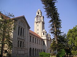
學院校舍的外表
印度科學理工學院(Indian Institute of Science,縮寫為 IISc)位於班加羅爾,於1909年為了完成塔塔集團創辦人賈姆希德吉·塔塔的遺願所設立,是印度歷史最悠久的科研和教育機構[3][4]。

Main Building

Corridors of Main Building

Aerospace Engineering Department (Interior)
Electrical Engineering Department

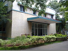
Signal Processing Building


外部連結
- 印度科學理工學院 官方網站
參考資料
^ IISc Leadership.
^ 2.02.1 IISc in Numbers. Indian Institute of Science. [19 July 2016].
^ 印度科學理工學院(Indian Institute of Science, IISc)簡介[永久失效連結]
^ General Info - About IISc 互联网档案馆的存檔,存档日期2008-04-15.
| 这是一篇與大学相關的小作品。你可以通过编辑或修订扩充其内容。 |


