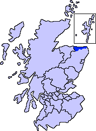
Banff and Buchan

Map of Scotland showing the present-day committee area of Banff and Buchan
- For the constituencies, see Banff and Buchan (Scottish Parliament constituency) or Banff and Buchan (UK Parliament constituency).
Banff and Buchan is a committee area of the Aberdeenshire Council, Scotland.
It has a population of 35,742 (2001 Census). Fishing and agriculture are important industries, together with associated processing and service activity.
Banff and Buchan was also the name of a district of Grampian Region between 1975 and 1996. The district covered a much larger area than the committee area, and included what are now the committee areas of Buchan, which, despite its name, is not part of the committee area of Banff and Buchan,[1] and Formartine.
Contents
1 Banff and Buchan committee area
2 Banff and Buchan district
3 Parliamentary constituencies
4 See also
5 References
Banff and Buchan committee area
The area is relatively self-contained, and in recent years has seen a small decline in population. It does, however, have tourism assets in its coastline, coastal villages and visitor attractions. Economic dependency, peripherality, and the future of the Common Fisheries/Agricultural Policies, are key issues. The Buchan Local Action Plan will address some of these concerns. The Area qualifies for European Union Objective 2 structural funding.
This region manifests prehistory by the ancient monument at Longman Hill, a large long barrow[2] somewhat to the southeast of Macduff, as well as Cairn Lee somewhat to the west of Longman Hill.
Banff and Buchan district

Banff and Buchan (red) within Scotland (white) within the United Kingdom (light grey).
Banff and Buchan was formerly a local government district in the Grampian region, created in 1975, under the Local Government (Scotland) Act 1973.[3] It combined, from the former county of Banff, a Banff area (including the burgh of Banff), the burghs of Aberchirder, Macduff and Portsoy, and Aberchirder and Fordyce areas, and, from the former county of Aberdeen, the burghs of Fraserburgh, Peterhead, Rosehearty and Turriff, and Cruden and Deer Turriff areas. (The rest of the county of Banff became part of the Moray district of the region.)
In 1996, the Banff and Buchan district was merged into the Aberdeenshire unitary council area, under the Local Government etc (Scotland) Act 1994. The former district was divided between the three committee areas of Banff and Buchan, Buchan (the area around Peterhead) and Formartine (the area around Ellon and Turriff).
Parliamentary constituencies
The name is also used for the Banff and Buchan (Westminster) constituency of the House of Commons of the Parliament of the United Kingdom (at Westminster). This seat has been held since 2017 by David Duiguid of the Conseravtive Party who gained it from Dr Eilidh Whiteford of the Scottish National Party. From 1999 to 2011 Banff and Buchan was also used as a constituency of the Scottish Parliament (at Holyrood). Despite sharing the same name, the boundaries of the two constituencies differed after 2005.
See also
- Subdivisions of Scotland
References
^ "Minutes of Buchan Area Committee". Aberdeenshire Council. 23 April 1996. Retrieved 6 June 2015..mw-parser-output cite.citation{font-style:inherit}.mw-parser-output q{quotes:"""""""'""'"}.mw-parser-output code.cs1-code{color:inherit;background:inherit;border:inherit;padding:inherit}.mw-parser-output .cs1-lock-free a{background:url("//upload.wikimedia.org/wikipedia/commons/thumb/6/65/Lock-green.svg/9px-Lock-green.svg.png")no-repeat;background-position:right .1em center}.mw-parser-output .cs1-lock-limited a,.mw-parser-output .cs1-lock-registration a{background:url("//upload.wikimedia.org/wikipedia/commons/thumb/d/d6/Lock-gray-alt-2.svg/9px-Lock-gray-alt-2.svg.png")no-repeat;background-position:right .1em center}.mw-parser-output .cs1-lock-subscription a{background:url("//upload.wikimedia.org/wikipedia/commons/thumb/a/aa/Lock-red-alt-2.svg/9px-Lock-red-alt-2.svg.png")no-repeat;background-position:right .1em center}.mw-parser-output .cs1-subscription,.mw-parser-output .cs1-registration{color:#555}.mw-parser-output .cs1-subscription span,.mw-parser-output .cs1-registration span{border-bottom:1px dotted;cursor:help}.mw-parser-output .cs1-hidden-error{display:none;font-size:100%}.mw-parser-output .cs1-visible-error{font-size:100%}.mw-parser-output .cs1-subscription,.mw-parser-output .cs1-registration,.mw-parser-output .cs1-format{font-size:95%}.mw-parser-output .cs1-kern-left,.mw-parser-output .cs1-kern-wl-left{padding-left:0.2em}.mw-parser-output .cs1-kern-right,.mw-parser-output .cs1-kern-wl-right{padding-right:0.2em}
^ C.Michael Hogan (2008) Longman Hill, Modern Antiquarian
^ Local Government (Scotland) Act, 1973

