Castilla Province
Castilla | |
|---|---|
Province | |
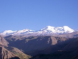 Coropuna as seen from Tipan | |
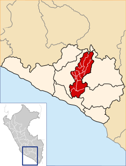 Location of Castilla in the Arequipa Region | |
| Country | Peru |
| Region | Arequipa |
| Capital | Aplao |
| Government | |
| • Mayor | Gilder Edy Medina Collado (2007) |
| Area | |
| • Total | 6,914.48 km2 (2,669.70 sq mi) |
| Population .mw-parser-output .nobold{font-weight:normal} (2005 census) | |
| • Total | 36,568 |
| • Density | 5.3/km2 (14/sq mi) |
| UBIGEO | 0404 |
| Website | www.municipiocastilla.gob.pe |
Castilla Province is one of eight provinces in the Arequipa Region of Peru. It was named after Ramón Castilla.
Contents
1 Geography
2 Political division
3 Ethnic groups
4 See also
5 Sources
6 External links
Geography
The Chila mountain range traverses the province. One of the highest mountains of the province is Coropuna at 6,425 m (21,079 ft) above sea level. Other mountains are listed below:[1]
- Apachita
- Asiruta
- Asnu Wañusqa
- Ayri Qutu
- Challwani
- Chila
- Chinchun
- Chuqi P'unqu
- Chuqi Pirwa
Chila (Cast.-Caylloma)- Chila Pilluni
- Ch'illkayuq
- Ch'uwañuma
- Ikma
- Janq'u Qala
- Kimsa Chata
- Kiska P'anqa
- Kuntur
- Kuntur Qaqa
- Kunturkhacha
- Llallawi
- Minasniyuq
- Pampa Qullqa
- Puka Mawras
Puka Mawras (Andagua)- Puma Ranra
- Pilluni
- Phusuqu
- P'aqu Urqu
- P'isqi P'isqi
- Qallwa
- Qaqamayu
- Qinchaña
- Qullpa
- Q'illa Q'illa
- Q'illu Q'illu
- Qillqani
- Sama Q'asa
- Sani
- Sawsi
- Sukna
- Sulimana
- Sulluku Llawa
- Sunqu
- Tiklla
Tiklla (Qaqamayu)- Tuqlla Tuqlla
- T'iksu
- Uqi Q'asa
- Usqullu
- Wakapallqa
- Waman Quri
- Wamanripayuq
- Wanqa
- Waña Q'awa
- Waqrawiri
- Waylla Tarpuna
- Wayrani
- Wayta
- Wayta Kuntur Sinqa
- Wayllayuq
- Willkani
- Yana Mawras
- Yana Qaqa
- Yana Urqu
- Yanawara
- Yanqha
- Yuraq Q'asa
Machuqucha is one of the largest lakes of the province.[1]
Political division
The province is divided into fourteen districts which are, with its capital in parenthesis:
Andagua (Andagua)
Aplao (Aplao)
Ayo (Ayo)
Chachas (Chachas)
Chilcaymarca (Chilcaymarca)
Choco (Choco)
Huancarqui (Huancarqui)
Machaguay (Machaguay)
Orcopampa (Orcopampa)
Pampacolca (Pampacolca)
Tipán (Tipán)
Uñón (Uñón)
Uraca (Corire)
Viraco (Viraco)
Ethnic groups
The province is inhabited by indigenous citizens of Aymara and Quechua descent. Spanish, however, is the language which the majority of the population (79.72%) learnt to speak in childhood, 18.52% of the residents started speaking using the Quechua language and 1.51% using Aymara (2007 Peru Census).[2]
See also
- Antamayu
- Mawk'allaqta
Sources
^ ab escale.minedu.gob.pe - UGEL maps of the Caylloma Province 1 and 2 (Arequipa Region)
^ inei.gob.pe Archived January 27, 2013, at the Wayback Machine. INEI, Peru, Censos Nacionales 2007
External links
(in Spanish) Official municipal website
| |
|---|---|
|
This Arequipa Region geography article is a stub. You can help Wikipedia by expanding it. |
Coordinates: 16°05′10″S 72°29′15″W / 16.086011°S 72.487611°W / -16.086011; -72.487611


