中心密集雲團區
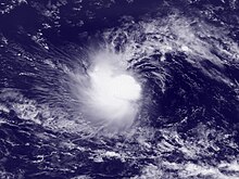
2009年熱帶風暴安娜的中心密集云團區
中心密集雲團區(英语:Central dense overcast,簡稱:CDO)是圍繞熱帶氣旋之中心的大型雲團區域,由其眼壁的發展而形成。它可以是圓形、有角、橢圓形或不規則的形狀[1],這個特徵出現在熱帶風暴或颶風強度的熱帶氣旋中。在風暴達到颶風強度後,風眼就會在中心密集雲團區的中心形成。中心密集雲團區與風眼的距離以及中心密集雲團區內的雲與風眼之間的溫差有助於確定熱帶氣旋的強度。強度不斷變化的熱帶氣旋在其中心密集云團區內,有比穩定的風暴更多的閃電。使用衛星圖像中熱帶氣旋的中央密集雲團區也可用於確定其強度。熱帶氣旋中的最高持續風速以及最高的降雨量通常位於中央密集雲團區的最冷雲層之下。
目录
1 特徵
2 風眼
3 強度預測
4 參考來源
5 參見
6 外部連結
特徵

南半球的熱帶氣旋溫斯頓帶有圍繞風眼的大型云團區
它是圍繞在衛星云圖上熱帶氣旋中心的大面積雷暴[2][3][4]。當熱帶氣旋的眼壁開始發展,其中央密集雲團區便會形成[5];其發展之前可以是窄而密集的C形對流帶。在發展初期,雲團區的形狀通常是有角或橢圓形的,隨著熱帶氣旋增強,雲團區的尺寸逐漸增大,並且顯得更為圓滑[6],並形成成熟的螺旋雲帶。在低垂直風切變的環境中,中心密集雲團區會較圓[3]
。熱帶氣旋中惡劣的天氣位於中央密集雲團區內最深的對流;但對於處於穩定狀態的熱帶氣旋,中央密集雲團區內幾乎完全沒有閃電活動[7]。
熱帶氣旋內最強的風一般是位於中心密集雲團區內最深的對流下,在衛星圖像上會被顯示為最冷的雲頂。[8]最大风速半径通常在中心密集雲團區最冷的雲層範圍內[8],亦為熱帶氣旋降雨最強的區域[9]。對於處於較穩定狀態的成熟熱帶氣旋來說,中心密集雲團區幾乎不會有任何闪电活動,而閃電通常會在較弱的熱帶氣旋及強度不斷變動的風暴中更為常見。[10]
風眼
中央密集雲團區中心的風眼是天氣平靜的地區。風暴的風眼是一個大致圓形的區域,直徑通常是30-65公里。氣旋最低的氣壓會在風眼測得,可能比風暴以外的大氣壓力低15%[11]。但在較弱的熱帶氣旋中,風眼不會太清晰[11]。
強度預測
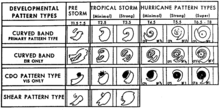
風暴強度預測圖
在熱帶氣旋的強度估計中,有幾種模式可以用來確定其強度的上限和下限。中央密集雲團區模式是其中之一,利用中央密集雲團區的大小來預計,同時也會考慮中央密集雲團區的形狀。風眼越靠近雲團區,風暴越強勁。中央密集雲團區模式強度從熱帶風暴強度開始,相當於每小時64公里[12][13]。
同時,中心密集雲團區的範圍增大,是熱帶氣旋逐漸增強的其中一個特徵。
但在每小時105公里和每小時160公里之間最高持續風速的熱帶氣旋可能會令可見光和紅外衛星圖像上的中心變得模糊,致使判斷其強度成為一個更大的挑戰[14]。
參考來源
^ Dvorak, Vernon F. A Technique For the Analysis and Forecasting of Tropical Cyclone Intensities From Satellite Pictures. National Oceanic and Atmospheric Administration: 5–8. 1973-02.
^ American Meteorological Society. AMS Glossary: C. Glossary of Meteorology. Allen Press. 2000-06 [2006-12-14]. (原始内容存档于2006-12-16).
^ 3.03.1 Landsea, Chris. What is a "CDO"?. Atlantic Oceanographic and Meteorological Laboratory. 2005-10-19 [2006-06-14]. (原始内容存档于2006-06-15).
^ Hebert, Paul H.; Kenneth O. Poteat. A Satellite Classification Technique For Subtropical Cyclones. National Weather Service Southern Region Headquarters: 9. July 1975.
^ Elsner, James B.; A. Birol Kara. Hurricanes of the North Atlantic: Climate and Society. Oxford University Press. 1999-06-10: 3. ISBN 978-0195125085.
^ Dvorak, Vernon F. Tropical Cyclone Intensity Analysis and Forecasting From Satellite Imagery. Monthly Weather Review. 1975-05, 103: 422. Bibcode:1975MWRv..103..420D. doi:10.1175/1520-0493(1975)103<0420:tciaaf>2.0.co;2.
^ Demetriades, Nicholas W.S.; Martin J. Murphy & Ronald L. Holle. Long Range Lightning Nowcasting Applications For Meteorology (PDF). Vaisala. 2005-06-22 [2012-08-12]. (原始内容存档 (PDF)于2015-10-02).
^ 8.08.1 Hsu, S. A.; Adele Babin. Estimating the Radius of Maximum Winds Via Satellite During Hurricane Lili (2002) Over the Gulf of Mexico (PDF). February 2005 [2007-03-18]. (原始内容 (PDF)存档于2012-02-06).
^ Muramatsu, Teruo. The Study on the Changes of the Three-dimensional Structure and the Movement Speed of the Typhoon through its Life Time (PDF). Tech. Rep. Meteorol. Res. Inst. Number 14. 1985: 3 [2009-11-20].
^ Demetriades, Nicholas W.S.; Martin J. Murphy & Ronald L. Holle. Long Range Lightning Nowcasting Applications For Meteorology (PDF). Vaisala. 2005-06-22 [2012-08-12].
^ 11.011.1 Landsea, Chris & Sim Aberson. What is the "eye"?. Atlantic Oceanographic and Meteorological Laboratory. 2004-08-13 [2006-06-14]. (原始内容存档于2011-07-04).
^ Velden, Chstopher; Bruce Harper; Frank Wells; John L. Beven II; Ray Zehr; Timothy Olander; Max Mayfield; Charles “Chip” Guard; Mark Lander; Roger Edson; Lixion Avila; Andrew Burton; Mike Turk; Akihiro Kikuchi; Adam Christian; Philippe Caroff & Paul McCrone. The Dvorak Tropical Cyclone Intensity Estimation Technique: A Satellite-Based Method That Has Endured For Over 30 Years (PDF). Bulletin of the American Meteorological Society. 2006-09: 1195–1214 [2012-09-26]. Bibcode:2006BAMS...87.1195V. doi:10.1175/bams-87-9-1195. (原始内容存档 (PDF)于2008-11-07).
^ Wimmers, Anthony J.; Christopher S. Velden. Objectively Determining the Rotational Center of Tropical Cyclones in Passive Microwave Satellite Imagery. Journal of Applied Meteorology and Climatology (American Meteorological Society). September 2012, 49 (9): 2013–2034. Bibcode:2010JApMC..49.2013W. doi:10.1175/2010jamc2490.1.
^ Wimmers, Anthony; Chistopher Velden. Advances in Objective Tropical Cyclone Center Fixing Using Multispectral Satellite Imagery (PDF). American Meteorological Society. 2012 [2012-08-12].
參見
- 風眼
- 德沃夏克分析法
外部連結
美國國家海洋及大氣管理局對其的描述(英文)
氣象研究所對其的描述(日文)


