居林
body.skin-minerva .mw-parser-output table.infobox caption{text-align:center}
| 居林市鎮 | |
|---|---|
市镇 | |
Kulim | |
 | |
坐标:5°21′36″N 100°32′59″E / 5.36°N 100.5497°E / 5.36; 100.5497 | |
| 国家 | |
| 州属 | |
| 人口(2015[1]) | |
| • 總計 | 85,309 |
| • 密度 | 590/平方公里(1,500/平方英里) |
| 时区 | 马来西亚标准时间 (UTC+8) |
居林(馬來語:Kulim)是马来西亚吉打州的一个县和大镇。位于吉打州南部。东北临华玲,南临万拉峇鲁。东临霹雳的司南马。西临槟城的威省北中南三县。居林为吉打州最邻近大槟城的城市。在這裡,從特易购到湖畔,從湖畔到新西園,從新西園到老火較都是屬於居林市镇范围。
居林鎮是居林县县府,位于居林县西部,是吉打州第三城镇,于亚罗士打和双溪大年之后。 居林高科技工业园是国内著名的工业区之一,带动了居林市的发展。
目录
1 名称由来
2 交通
2.1 陆路
2.2 巴士
2.3 空路
3 主要市镇
4 教育
4.1 小学
4.1.1 华文小学
4.1.2 国民小学
4.1.3 淡米尔文小学
4.2 中学
4.3 高等教育
5 景点
5.1 居林独立钟楼
5.2 西林树顶吊桥
5.3 其他
6 参考文献
7 外部衔接
名称由来
居林的名称是源自居林树(Pokok Kulim)。居林树是一种生长于马来西亚以及其他东南亚国家的一种植物。
交通
陆路
居林可通过从诗不朗再也至鲁乃的![]() 北海-居林大道(Butterworth-Kulim Expressway)抵达。主要道路则有从大山脚至居林市区的
北海-居林大道(Butterworth-Kulim Expressway)抵达。主要道路则有从大山脚至居林市区的![]() 居林路和横贯居林市的
居林路和横贯居林市的![]() 联邦136号公路。
联邦136号公路。
巴士
居林部分地区提供槟城快捷通巴士服务。
空路
距离居林最近的机场是槟城国际机场。2014年5月,吉打州务大臣拿督斯里慕克里宣布,计划在居林兴建国际机场[2][3]。吉打州工业及投资事务委员会主席拿督古阿都拉曼表示,居林国际机场兴建建议可执行性研究报告,预计将于2015年11月完成[4][5]。
主要市镇
- 居林市区
鲁乃(Lunas)- 老火较(Kelang Lama)
巴东色海(Padang Serai)- 加拉岸(Karangan)
- 加拉里(Keladi)
- 双溪西廊(Sungai Seluang)
- 双溪谷(Sungai Kob)
教育
小学
华文小学
- 老火较华小
- 居林觉民A校
- 居林觉民B校
- 居林中正华小
- 鲁乃华民华小
- 加拉岸华民华小
- 巴东色海尚正华小
- 三巴央新民华小
国民小学
- 斯里居林国小(SK Seri Kulim)
- 居林国小(SK Kulim)
- 巴也勿刹路国小(SK Jalan Paya Besar)
- 阿逸美拉国小(SK Air Merah)
- 东姑阿都马烈国小(SK Tunku Abdul Malik)
淡米尔文小学
- 居林淡小(SMK Kulim)
中学
苏丹巴力莎中学(SMK Sultan Badlishah)- 居林国中(SMK Kulim)
觉民华文中学(SMJK Chio Min)- 新西园国中(SMK Taman Selasih)
- 阿逸美拉国中(SMK Air Merah)
- 三巴央国中(SMK Junjung)
- 日落洞花园国中(SMK Taman Jelutong)
- 高科技工业园国中(SMK Taman Hitech)
- 加拉里国中(SMK Keladi)
- 东姑邦里玛勿刹国中(SMK Tunku Panglima Besar)
- 双溪谷国中(SMK Sungai Kob)
- 巴也勿刹路国中(SMK Jalan Paya Besar)
高等教育
吉隆坡大学(马来西亚西班牙语学院)- 端姑苏丹娜峇希雅理工学院(Politeknik Tuanku Sultanah Bahiyah)
居林社区学院(Kolej Komuniti Kulim)
景点
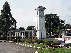
居林独立钟楼
居林独立钟楼位于居林大街与武吉阿威路的交界处。其建造耗时三个月左右,并于1957年9月15日,也就是马来亚独立大约两个星期后,由吉打苏丹苏丹巴力莎进行开幕,成为居林的非正式地标[6][7][8]。
西林树顶吊桥
西林树顶吊桥(Sungai Sedim Tree Top Walk)位于双溪西林休闲公園(Sedim River Recreation Park),長達950米,是全球最長的吊橋走道。西林樹頂吊橋建于英納斯森林保護區(Gunung Inas Forest Reserve)15區的龍腦香林的低地內。[9]
其他
- 居林新世纪广场
- 居林特易购(Tesco Kulim)
- 永顺超市(Minat)
- 三巴央阿逸布爹瀑布
- 吉南华人体育会(South Kedah Chinese Recreation Club Kedah)
参考文献
^ Website of Kulim municipal 互联网档案馆的存檔,存档日期2016-01-24., Population data published by Kulim municipal
^ 存档副本. [2016-05-01]. (原始内容存档于2014-11-09). , 南洋网:居林 动起来, 2014年11月7日
^ [1] Lapangan Terbang Antarabangsa Kulim Bakal Jadi Kenyataan, Mar 19, 2016
^ [2] Berita Harian: Kajian pembinaan lapangan terbang Kulim siap November, Julai 7, 2015
^ [3] 东方网:居林机场计划 研究报告11月完成, 2015年7月7日
^ Kulim’s Background 互联网档案馆的存檔,存档日期2010-04-08., Laman Web Rasmi Majlis Perbandaran Kulim (Official Website of Kulim Government). January 16, 2010.
^ Kulim’s City Centre 互联网档案馆的存檔,存档日期2010-10-31., Kulim’s Municipal council website-Kulim’s Background October 31, 2010.
^ [4], 星洲网:看我自拍,居林独立钟楼,走过半个多世纪,刘必强,2016年4月5日
^ [5]树顶吊桥
外部衔接
维基共享资源中相关的多媒体资源:居林 |
- 居林市议会官网
- 居林动起来
 | 槟城 | 瓜拉姆达 | 华玲 | |
槟城 | 华玲 / 司南马 | |||
| ||||
槟城 | 万拉峇鲁 | 司南马 |
| ||||||||||||||||||||||||||||||||||||||||||||||||||||||||||||||||||||||


