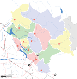
Una, Himachal Pradesh
Una | |
|---|---|
Town | |
 Una Location in Himachal Pradesh, India | |
| Coordinates: 31°28′05″N 76°16′16″E / 31.468°N 76.271°E / 31.468; 76.271Coordinates: 31°28′05″N 76°16′16″E / 31.468°N 76.271°E / 31.468; 76.271 | |
| Country | |
| State | Himachal Pradesh |
| District | Una |
| Elevation | 369 m (1,211 ft) |
| Population (2011) | |
| • Total | 18,722 |
| • Rank | 10 in HP |
| Languages | |
| • Official | Hindi |
| • Other spoken | Punjabi |
| Time zone | UTC+5:30 (IST) |
| Website | hpuna.nic.in |
Una is a municipal council town in Una district in the Indian state of Himachal Pradesh. It serves as the headquarters of Una district. Una is home to the Kila, which is a historical fort and an ancestral home of the descendants of the first guru of the Sikhs, Guru Nanak.[1]
Contents
1 Geography and climate
2 Demographics
3 Transport
4 Places to Visit in and near Una
5 References
Geography and climate
Una is located at 31°29′N 76°17′E / 31.48°N 76.28°E / 31.48; 76.28.[2] It has an average elevation of 369 metres (1,210 feet).
| Climate data for Una (1985–2000) | |||||||||||||
|---|---|---|---|---|---|---|---|---|---|---|---|---|---|
| Month | Jan | Feb | Mar | Apr | May | Jun | Jul | Aug | Sep | Oct | Nov | Dec | Year |
| Record high °C (°F) | 31.0 (87.8) | 34.2 (93.6) | 39.4 (102.9) | 43.2 (109.8) | 45.2 (113.4) | 45.2 (113.4) | 42.2 (108.0) | 38.4 (101.1) | 38.6 (101.5) | 35.6 (96.1) | 33.4 (92.1) | 28.2 (82.8) | 45.2 (113.4) |
| Average high °C (°F) | 19.5 (67.1) | 22.2 (72.0) | 26.6 (79.9) | 33.2 (91.8) | 37.2 (99.0) | 37.8 (100.0) | 33.5 (92.3) | 32.4 (90.3) | 32.5 (90.5) | 30.6 (87.1) | 27.0 (80.6) | 21.9 (71.4) | 29.5 (85.1) |
| Average low °C (°F) | 4.0 (39.2) | 5.8 (42.4) | 9.6 (49.3) | 13.8 (56.8) | 18.8 (65.8) | 21.9 (71.4) | 23.0 (73.4) | 22.8 (73.0) | 21.0 (69.8) | 14.1 (57.4) | 8.5 (47.3) | 4.4 (39.9) | 14.0 (57.2) |
| Record low °C (°F) | −5.8 (21.6) | −1.6 (29.1) | 3.0 (37.4) | 6.7 (44.1) | 8.6 (47.5) | 14.7 (58.5) | 17.0 (62.6) | 16.3 (61.3) | 13.4 (56.1) | 5.1 (41.2) | 1.8 (35.2) | −2.4 (27.7) | −5.8 (21.6) |
| Average rainfall mm (inches) | 38.9 (1.53) | 43.2 (1.70) | 43.1 (1.70) | 23.6 (0.93) | 42.0 (1.65) | 86.5 (3.41) | 397.2 (15.64) | 333.0 (13.11) | 189.7 (7.47) | 16.7 (0.66) | 14.4 (0.57) | 28.4 (1.12) | 1,256.6 (49.47) |
| Average rainy days | 2.4 | 3.8 | 3.6 | 1.4 | 3.2 | 5.1 | 11.3 | 11.5 | 5.7 | 1.1 | 1.1 | 1.5 | 51.6 |
| Source: India Meteorological Department[3] | |||||||||||||
Demographics
According to the 2011 Census of India, Una town had a population of 18,722 with 9,851 males and 8,871 females.[4] The literacy rate was 86.21%, higher than the state average of 82.80%.[4] The male literacy and female literacy rates were 88.84 and 83.29% respectively. There were 1,954 children below the age of six years. The sex ratio and child sex ratio of the town stood at 901 and 918 respectively.[4]Hindi and Punjabi are the main spoken languages.
Transport
Una is well connected to Himachal and rest of India through National Highway 503 and National Highway 503A.[5]
Places to Visit in and near Una
- Gobind Sagar
- Chintpurni
- Amb
- Bangana
- Bharwain
- Raipur Maidan
- Mairi
- Bhanjal
- Dera Baba Rudra Nand
- Chalola
References
^ "Kila Baba Sahib Singh Ji Bedi Una Sahib". HP Tours. Retrieved 16 May 2018..mw-parser-output cite.citation{font-style:inherit}.mw-parser-output .citation q{quotes:"""""""'""'"}.mw-parser-output .citation .cs1-lock-free a{background:url("//upload.wikimedia.org/wikipedia/commons/thumb/6/65/Lock-green.svg/9px-Lock-green.svg.png")no-repeat;background-position:right .1em center}.mw-parser-output .citation .cs1-lock-limited a,.mw-parser-output .citation .cs1-lock-registration a{background:url("//upload.wikimedia.org/wikipedia/commons/thumb/d/d6/Lock-gray-alt-2.svg/9px-Lock-gray-alt-2.svg.png")no-repeat;background-position:right .1em center}.mw-parser-output .citation .cs1-lock-subscription a{background:url("//upload.wikimedia.org/wikipedia/commons/thumb/a/aa/Lock-red-alt-2.svg/9px-Lock-red-alt-2.svg.png")no-repeat;background-position:right .1em center}.mw-parser-output .cs1-subscription,.mw-parser-output .cs1-registration{color:#555}.mw-parser-output .cs1-subscription span,.mw-parser-output .cs1-registration span{border-bottom:1px dotted;cursor:help}.mw-parser-output .cs1-ws-icon a{background:url("//upload.wikimedia.org/wikipedia/commons/thumb/4/4c/Wikisource-logo.svg/12px-Wikisource-logo.svg.png")no-repeat;background-position:right .1em center}.mw-parser-output code.cs1-code{color:inherit;background:inherit;border:inherit;padding:inherit}.mw-parser-output .cs1-hidden-error{display:none;font-size:100%}.mw-parser-output .cs1-visible-error{font-size:100%}.mw-parser-output .cs1-maint{display:none;color:#33aa33;margin-left:0.3em}.mw-parser-output .cs1-subscription,.mw-parser-output .cs1-registration,.mw-parser-output .cs1-format{font-size:95%}.mw-parser-output .cs1-kern-left,.mw-parser-output .cs1-kern-wl-left{padding-left:0.2em}.mw-parser-output .cs1-kern-right,.mw-parser-output .cs1-kern-wl-right{padding-right:0.2em}
^ Falling Rain Genomics, Inc - Una
^ "Ever recorded Maximum and minimum temperatures up to 2010" (PDF). India Meteorological Department. Archived from the original (PDF) on 21 May 2013. Retrieved 18 April 2016.
^ abc "Una Population Census 2011". Census 2011 India. Retrieved 28 April 2018.
^ "National Highways in Himachal Pradesh" (PDF). Himachal Pradesh Public Works Department. Retrieved 23 May 2018.
