阿爾瓦塞特省
body.skin-minerva .mw-parser-output table.infobox caption{text-align:center}
| Albacete | |||
|---|---|---|---|
省 | |||
| |||
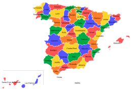
 Albacete 在西班牙的位置 | |||
坐标:38°50′N 2°00′W / 38.83°N 2°W / 38.83; -2 | |||
| 自治区 | 卡斯蒂利亞-拉曼恰 | ||
| 首府 | 阿爾瓦塞特 | ||
| 政府 | |||
| • 类型 | 阿尔瓦塞特省议会 | ||
| • 省长 | Pedro Aº Ruiz Santos(PSOE) | ||
| 面积 | |||
| • 总计 | 14,924 平方公里(5,762 平方英里) | ||
| 面积排名 | 第9名 | ||
| 人口(2017年) | |||
| • 總計 | 390,032 | ||
| • 排名 | 第35名 | ||
| • 密度 | 26/平方公里(68/平方英里) | ||
| 官方语言 | 西班牙語 | ||
| 網站 | http://www.dipualba.es/ | ||

阿爾瓦塞特省(西班牙語:Provincia de Albacete, 發音:[alβaˈθete])為西班牙中部的一個省份,位於卡斯蒂利亞-拉曼恰自治區的南部。它的周圍有瓦倫西亞省、阿利坎特省、穆爾西亞省、格拉納達省、哈恩省、雷阿爾城省、以及昆卡省。首府為阿爾瓦塞特。
阿爾瓦塞特省土地面積為14,924平方公里。[1]2005年人口有384,640,2017年人口有390,032。[2]
目录
1 地理
2 人口
3 图集
4 参考文献
地理
西北: 雷阿爾城省 | 北: 昆卡省 和 巴倫西亞省 | 东北: 巴倫西亞省 |
西: 雷阿爾城省 和 哈恩省 |  | 东: 巴倫西亞省, 阿利坎特省 和 穆尔西亚地区 |
西南: 哈恩省 和 格拉納達省 | 南: 穆尔西亚地区 | 东南: 穆尔西亚地区 |
人口
| 阿尔瓦塞特省人口变化表[3] | |||||||||||||
|---|---|---|---|---|---|---|---|---|---|---|---|---|---|
1857 | 1887 | 1900 | 1910 | 1920 | 1930 | 1940 | 1950 | ||||||
201 118 | 231 073 | 237 877 | 264 698 | 291 833 | 332 619 | 374 472 | 397 100 | ||||||
1960 | 1970 | 1981 | 1991 | 2000 | 2005 | 2010 | 2015 | ||||||
370 976 | 335 026 | 334 468 | 341 847 | 363 263 | 384 640 | 401 682 | 394 580 | ||||||
| 2013年阿尔瓦塞特省外来人口统计 | |||||||
|---|---|---|---|---|---|---|---|
| 排名 | 国家 | 人口 | |||||
| 1 | 8940 | ||||||
| 2 | 4764 | ||||||
| 3 | 2685 | ||||||
| 4 | 1635 | ||||||
| 5 | 1398 | ||||||
| 6 | 1342 | ||||||
| 7 | 1168 | ||||||
| 8 | 1071 | ||||||
| 9 | 673 | ||||||
| 10 | 639 | ||||||
| 2017年阿尔瓦塞特省市镇人口排名 | ||||||||||
|---|---|---|---|---|---|---|---|---|---|---|
| 排名 | 市镇 | 区 | 人口 | 排名 | 市镇 | 区 | 人口 |
| |
| 1 | 阿尔瓦塞特 | Los Llanos | 172 816 | 11 | 钦奇利亚德蒙特-阿拉贡 | Mancha de Montearagón | 4,213 | |||
| 2 | 埃林 | Campos de Hellín | 30 184 | 12 | 比利亚马莱亚 | La Manchuela | 4,124 | |||
| 3 | 比利亚罗夫莱多 | La Mancha del Júcar-Centro | 25 317 | 13 | 埃尔切德拉谢拉 | Sierra del Segura | 3,666 | |||
| 4 | 阿尔曼萨 | Corredor de Almansa | 24 566 | 14 | 穆内拉 | Campo de Montiel | 3,572 | |||
| 5 | 拉罗达 | Mancha Alta Albaceteña | 15 603 | 15 | 埃尔沃尼略 | Campo de Montiel | 2,852 | |||
| 6 | 考德特 | Corredor de Almansa | 10 010 | 16 | 波索卡尼亚达 | Mancha de Montearagón | 2,800 | |||
| 7 | 托瓦拉 | Campos de Hellín | 7,754 | 17 | 耶斯特 | Sierra del Segura | 2,742 | |||
| 8 | 塔拉索纳德拉曼查 | Mancha de Montearagón | 6,363 | 18 | 丰特-阿拉莫 | Campos de Hellín | 2,531 | |||
| 9 | 马德里格拉斯 | La Manchuela | 4,647 | 19 | 拉希内塔 | Mancha de Montearagón | 2,457 | |||
| 10 | 卡萨斯-伊瓦涅斯 | La Manchuela | 4,558 | 20 | 奥萨德蒙铁尔 | Campo de Montiel | 2,411 | |||
| 来源:2017年INE.[4] | ||||||||||


图集

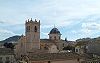
行政区划
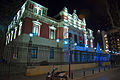
省议会

里奥帕尔市的蒙多河

阿爾卡拉斯山脈


参考文献
^ Superficie y altimetría.INE.[2018-09-05]
^ Población por provincias.INE.[2018-09-05]
^ INEpop
^ Instituto nacional de estadística. 2017 [2017-12-29].
| ||||||||||||||||||||||||||||||||||||||||||||||||