Zenica-Doboj Canton
Zenica-Doboj Canton Zeničko-dobojski kanton[1] Zeničko-dobojski kanton (bs) Zeničko-dobojska županija (hr) Зеничко-добојски кантон (sr) | |||
|---|---|---|---|
Canton | |||
| |||
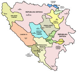
 Location of the Zenica-Doboj Canton | |||
| Coordinates: 44°14′N 18°12′E / 44.233°N 18.200°E / 44.233; 18.200 | |||
| Country | Bosnia and Herzegovina | ||
| Entity | Federation of Bosnia and Herzegovina | ||
| Main city | Zenica | ||
| Municipalities | List
| ||
| Government | |||
| • Head of canton | Miralem Galijašević | ||
| Area | |||
| • Total | 3,415.3 km2 (1,318.7 sq mi) | ||
| Population (2013 census)[2] | |||
| • Total | 385,067 | ||
| • Density | 112.75/km2 (292.0/sq mi) | ||
| ISO 3166 code | BA-04 | ||
| Website | www.zdk.ba | ||

Cantons of the Federation of Bosnia and Herzegovina.
The Zenica-Doboj Canton (Bosnian: Zeničko-dobojski kanton[1]) is one of 10 cantons of the Federation of Bosnia and Herzegovina in Bosnia and Herzegovina. The capital is Zenica.
Contents
1 History
1.1 2013 Census
2 Geography
3 Municipalities
4 See also
5 References
History
During the protests and riots in Bosnia and Herzegovina in February 2014, the entire government of the Zenica-Doboj Canton resigned.[3][4]
2013 Census
| Nationality | Total | |||||
|---|---|---|---|---|---|---|
Bosniaks | % | Croats | % | Serbs | % | |
| 299,462 | 82.17 | 43,819 | 12.02 | 5,543 | 1.52 | 364,433 |
[5]
Geography
This canton is situated in the central part of Bosnia and Herzegovina. The cantonal capital is Zenica and the other town mentioned in the name is Doboj, which is in Republika Srpska, but part of the former Doboj municipality is in the Zenica-Doboj Canton. The canton has an area of 3,904 km2.
Municipalities
The canton is split into the municipalities of Breza, Doboj Jug, Kakanj, Maglaj, Olovo, Tešanj, Vareš, Visoko, Zavidovići, Zenica, Žepče, Usora.
See also
- Political divisions of Bosnia and Herzegovina
- List of heads of the Zenica-Doboj Canton
Zenica coal mine one of the largest deposits in Europe
References
^ ab The Constitution of the Zenica-Doboj Canton Archived April 10, 2012, at the Wayback Machine Official name of canton is Zenica-Doboj Canton
^ "First release" (PDF). Federal Office of Statistics, Federation of Bosnia and Herzegovina. June 30, 2011..mw-parser-output cite.citation{font-style:inherit}.mw-parser-output .citation q{quotes:"""""""'""'"}.mw-parser-output .citation .cs1-lock-free a{background:url("//upload.wikimedia.org/wikipedia/commons/thumb/6/65/Lock-green.svg/9px-Lock-green.svg.png")no-repeat;background-position:right .1em center}.mw-parser-output .citation .cs1-lock-limited a,.mw-parser-output .citation .cs1-lock-registration a{background:url("//upload.wikimedia.org/wikipedia/commons/thumb/d/d6/Lock-gray-alt-2.svg/9px-Lock-gray-alt-2.svg.png")no-repeat;background-position:right .1em center}.mw-parser-output .citation .cs1-lock-subscription a{background:url("//upload.wikimedia.org/wikipedia/commons/thumb/a/aa/Lock-red-alt-2.svg/9px-Lock-red-alt-2.svg.png")no-repeat;background-position:right .1em center}.mw-parser-output .cs1-subscription,.mw-parser-output .cs1-registration{color:#555}.mw-parser-output .cs1-subscription span,.mw-parser-output .cs1-registration span{border-bottom:1px dotted;cursor:help}.mw-parser-output .cs1-ws-icon a{background:url("//upload.wikimedia.org/wikipedia/commons/thumb/4/4c/Wikisource-logo.svg/12px-Wikisource-logo.svg.png")no-repeat;background-position:right .1em center}.mw-parser-output code.cs1-code{color:inherit;background:inherit;border:inherit;padding:inherit}.mw-parser-output .cs1-hidden-error{display:none;font-size:100%}.mw-parser-output .cs1-visible-error{font-size:100%}.mw-parser-output .cs1-maint{display:none;color:#33aa33;margin-left:0.3em}.mw-parser-output .cs1-subscription,.mw-parser-output .cs1-registration,.mw-parser-output .cs1-format{font-size:95%}.mw-parser-output .cs1-kern-left,.mw-parser-output .cs1-kern-wl-left{padding-left:0.2em}.mw-parser-output .cs1-kern-right,.mw-parser-output .cs1-kern-wl-right{padding-right:0.2em}
^ "Government of Zenica-Doboj Canton Resigned". Sarajevo Times. 7 February 2014. Retrieved 1 April 2015.
^ "Vlada Zeničko-dobojskog kantona podnosi ostavku". RTVBN. 7 February 2014. Retrieved 1 April 2015.
^ Link text, additional text.
Coordinates: 44°14′N 18°12′E / 44.233°N 18.200°E / 44.233; 18.200

