Deccan States Agency
| Deccan States Agency | |||||
Agency of British India | |||||
| |||||
 | |||||
History | |||||
| • | Merger of Kolhapur Agency and four smaller agencies | 1933 | |||
| • | Merger into Bombay State following Independence of India | 1947 | |||
"A collection of treaties, engagements, and sunnuds relating to India and neighbouring countries" | |||||
| Princely state |
|---|
|
Individual residencies |
|
Agencies |
|
Lists |
|
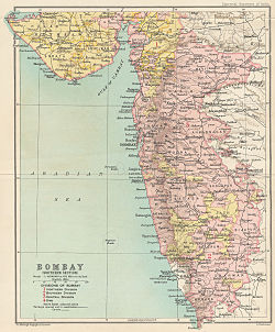
The Deccan States Agency, also known as the Deccan States Agency and Kolhapur Residency, was a political agency of British India, managing the relations of the British government of the Bombay Presidency with a collection of princely states[1] and jagirs (feudal 'vassal' estates) in western India.
Contents
1 History
2 Princely (e)states
2.1 States of the former Kolhapur Agency
2.2 Jagirs of the former Kolhapur Agency
2.3 States of the other former colonial agencies
3 See also
4 References
History
The agency was created 1933 with the merger of the Kolhapur Agency (Kolhapur Residency), Poona Agency, Bijapur Agency, Dharwar Agency and Kolaba Agency.
It was composed of a number of princely states and jagirs in Western India, located in the present-day Indian states of Maharashtra and Karnataka, six of which were Salute states. The princely states included in the agency were under the suzerainty, but not the control, of the British authorities of the Bombay Presidency.
After Indian Independence in 1947, the states all acceded to the Dominion of India, and were integrated into the Indian state of Bombay.[2] In 1956 the Kannada language speaking southern portion of Bombay state, which included the former states of the Southern Maratha Country, was transferred to Mysore State (later renamed Karnataka). Bombay State was divided into the new states of Maharashtra and Gujarat in 1960.[3]
Princely (e)states
States of the former Kolhapur Agency
Salute states, by precedence :
Kolhapur, title Maharaja; Hereditary 19-guns salute
Janjira, title Nawab; Hereditary 11-guns (13-guns local):
Sangli, title Raja; Hereditary 9-guns (11-guns personal)
Mudhol, title Raja; Hereditary 9-guns
Non-salute states, alphabetically :
Akalkot, title Raja
Aundh, title Pant Pratinidhi
Jamkhandi, title Raja
Kurundwad Junior, title Rao
Kurundwad Senior, title Rao
Miraj Junior, title Rao
Miraj Senior, title Rao
Phaltan, title Naik
Ramdurg, title Raja
Jagirs of the former Kolhapur Agency
- Bavda estate
Gajendragad (Gajendragarh),- ? Saranjam
- ? Himmat Bahadur
- Ichalkaranji estate
- Kagal Junior
- Kagal Senior
- Kapshi estate
- Latur estate
- Sar Lashkar
- Torgal Jagir
- Vishalgad estate
States of the other former colonial agencies
Former Bijapur Agency, both non-salute :
Daphlapur (Daflepur), title Deshmukh (1917 incorporated in Jath, below)
Jath (Joth), title Raja (till 1936 Deshmukh)
Former Kolaba Agency:
Sawantwadi (Savantwadi), title title Raja Bahadur; Hereditary salute of 9-guns (11-guns local)
Former Dharwar Agency : non-salute :
Savanur, title Nawab
Former Poona Agency :
Bhor, title Raja, Hereditary salute of 9-guns
See also
- List of Maratha dynasties and states
- Maratha Empire
References
^ "Gazetteer of the Bombay Presidency"
^ Political and administrative integration of princely states By S. N. Sadasivan..mw-parser-output cite.citation{font-style:inherit}.mw-parser-output .citation q{quotes:"""""""'""'"}.mw-parser-output .citation .cs1-lock-free a{background:url("//upload.wikimedia.org/wikipedia/commons/thumb/6/65/Lock-green.svg/9px-Lock-green.svg.png")no-repeat;background-position:right .1em center}.mw-parser-output .citation .cs1-lock-limited a,.mw-parser-output .citation .cs1-lock-registration a{background:url("//upload.wikimedia.org/wikipedia/commons/thumb/d/d6/Lock-gray-alt-2.svg/9px-Lock-gray-alt-2.svg.png")no-repeat;background-position:right .1em center}.mw-parser-output .citation .cs1-lock-subscription a{background:url("//upload.wikimedia.org/wikipedia/commons/thumb/a/aa/Lock-red-alt-2.svg/9px-Lock-red-alt-2.svg.png")no-repeat;background-position:right .1em center}.mw-parser-output .cs1-subscription,.mw-parser-output .cs1-registration{color:#555}.mw-parser-output .cs1-subscription span,.mw-parser-output .cs1-registration span{border-bottom:1px dotted;cursor:help}.mw-parser-output .cs1-ws-icon a{background:url("//upload.wikimedia.org/wikipedia/commons/thumb/4/4c/Wikisource-logo.svg/12px-Wikisource-logo.svg.png")no-repeat;background-position:right .1em center}.mw-parser-output code.cs1-code{color:inherit;background:inherit;border:inherit;padding:inherit}.mw-parser-output .cs1-hidden-error{display:none;font-size:100%}.mw-parser-output .cs1-visible-error{font-size:100%}.mw-parser-output .cs1-maint{display:none;color:#33aa33;margin-left:0.3em}.mw-parser-output .cs1-subscription,.mw-parser-output .cs1-registration,.mw-parser-output .cs1-format{font-size:95%}.mw-parser-output .cs1-kern-left,.mw-parser-output .cs1-kern-wl-left{padding-left:0.2em}.mw-parser-output .cs1-kern-right,.mw-parser-output .cs1-kern-wl-right{padding-right:0.2em}
^ Ramachandra Guha, India after Gandhi: The History of the World's Largest Democracy. HarperCollins, 2007
Coordinates: 16°41′N 74°14′E / 16.683°N 74.233°E / 16.683; 74.233


