Stephenville, Newfoundland and Labrador
Town of Stephenville | ||
|---|---|---|
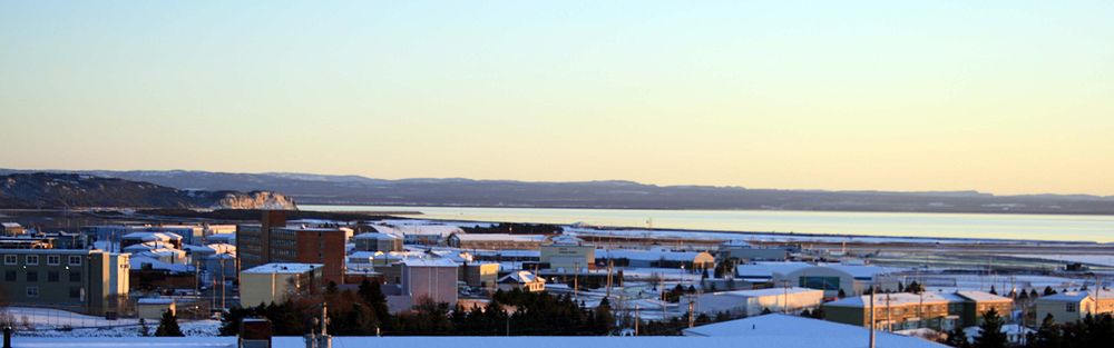
 Overlooking the town of Stephenville | ||
| ||
 Town of Stephenville Location of Stephenville in Newfoundland | ||
| Coordinates: 48°33′N 58°34′W / 48.550°N 58.567°W / 48.550; -58.567 | ||
| Country | ||
| Province | ||
| Incorporated | 1952 | |
| Government | ||
| • Mayor | Tom Rose | |
| • Governing body | Stephenville Town Council | |
| • MHA | John Finn | |
| • MP | Gudie Hutchings | |
| Area | ||
| • Total | 35.69 km2 (13.78 sq mi) | |
| Elevation | 0 - 74 m (0 - 243 ft) | |
| Population (2016)[1] | ||
| • Total | 6,623 | |
| • Density | 185.6/km2 (481/sq mi) | |
| Time zone | UTC-3:30 (Newfoundland Time) | |
| • Summer (DST) | UTC-2:30 (Newfoundland Daylight) | |
| Postal code span | A2N | |
| Area code(s) | 709 | |
| Telephone Exchange | 643, 283, 214, 649, 641 and 721 | |
| Median Family Income* | $61,184 | |
NTS Map | 012B10 | |
GNBC Code | AAXZD | |
| Website | Town of Stephenville official website | |
| ||

Stephenville (Canada 2016 Census population 6,623[1]) is a town in Newfoundland and Labrador, Canada on the west coast of the island of Newfoundland.
The town functions as a local service centre for the southwestern part of the island, serving a direct population of 35,000 people from surrounding areas and over 100,000 people along the entire southwestern coast of the island.[2]
Stephenville has a modern 40-bed hospital (built in 2003), schools, stores, movie theater, banks, and International Airport (Stephenville International Airport, CYJT), year round ice free sea port (Port Harmon), and government institutions. The provincial community college system, College of the North Atlantic, is headquartered in Stephenville and maintains a campus there for students from the southwestern region of the island. A provincial minimum security jail is also located in the town.
Contents
1 History
2 Transportation
3 Economic development
4 Education
5 Geography
5.1 Climate
6 Demographics
7 Arts and entertainment
8 Sports and recreation
9 Notable people
10 Notable events
11 Sister city
12 See also
13 References
14 External links
History
This place was formerly known as the Acadian village, between 1848 and 1870. The populace of the village consisted of Roman Catholics who eked out a living, farming and fishing. The town's population continued to grow because of the stable economy. It was also formerly home to Ernest Harmon AFB, which was operated by the United States Army Air Forces and later the United States Air Force from 1941 to 1966.
The base precipitated an economic boom of sorts on Newfoundland's southwest coast during the 1940s. Corner Brook to the northeast had been considered the major population center for the region, given its industrial base and nearby recreational opportunities in the Humber River. With the massive investment of the Government of the United States in the base, the Stephenville and St. George's Bay area began to flourish. The village of Stephenville grew from a hamlet of several hundred people with no paved streets, side walks, water or sewage system in 1941 into a modern town of over 5,000 by the mid-1950s. By the time Ernest Harmon AFB closed in 1966, the town had more than doubled in size, partly as a result of the provincial government's forced resettlement policy toward residents of outports.
After the base was closed, the facility was turned over to the federal government which then provided it to the provincial government to diversify the local community.
The facility included the air field, which has two runways (10,000 ft x 200 ft, 4,000 ft x 150 ft) and numerous buildings which are operated as the Stephenville International Airport. An abandoned USAF Pinetree Line radar site is located on nearby Table Mountain, north of the town. The town uses many former USAF structures for housing, recreation and entertainment.
Transportation
The Stephenville International Airport, formerly Ernest Harmon AFB, serves the entire west coast of the island - a catchment population of 100,000 people from Port aux Basques to Corner Brook, currently offering intraprovincial flights with Provincial Airlines, weekly summer air service is offered to Toronto Pearson with Sunwing Airlines, twice weekly international flights are offered to Saint-Pierre et Miquelon, France in February, June and August with Air Saint Pierre, weekly flights to Halifax, Ottawa and Toronto (Billy Bishop Airport) with Porter Airlines operates from April to January connecting to its network in Canada and the U.S.A. As well, Stephenville Airport is an international port of entry airport; the airport is the alternate refueling airport to Gander International.
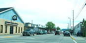
Main Street, Stephenville
Daily intraprovincial bus service connecting to major population centres and ferry terminals across the island is provided by DRL Coachlines. Dedicated bus service between Stephenville and Corner Brook is provided by Eddy's Bus Services. Dedicated bus service between Stephenville and Port aux Basques is provided by Gateway Bus Service.
Three taxi companies serve the town: Crown Taxi, Blue Bird Taxi, and United Class Cabs.
The town is located 15 kilometres northwest of the Trans-Canada Highway, and is accessible using Provincial Highway Routes 490 and 460.
Rail service to the town, as well as all of Newfoundland, was discontinued by Terra Transport in 1988.
The density of the town core, and its flat topography, permit residents to enjoy outdoor activities such as walking, bicycling, roller blading, and cross-country skiing.
Economic development

Stephenville at Night
According to the 2011 Canada Census, Stephenville's population increased by 2% since 2006. This marked the first increase in population since 1996, when population increased by 1.9% over 1991's number. Population further declined in the 2016 Canada Census by 1.4 % compared to 2011's population.
The town has developed an economic development strategy, known as Live-Work-Grow.[3] The website is intended to help attract new and expanding businesses to the area as the town continues to try and diversify its economy. Live-Work-Grow, along with the municipal website, contain all the information needed to study the market and also allow for the completion of online permit applications. This is intended to simplify the permit process and is exemplary of the business friendly atmosphere the town administration is trying to foster. As of November 2018, however, the website is no longer active.
Education
The first educational institution in the Bay St. George area was the Roman Catholic Church. Bishop John T. Mullock established the first church of the Roman Catholic faith at Sandy Point in 1848 when the population of the area was about 2000. Father Belenger was the first priest in the St. Georges Bay area from 1850 to 1868. Father Sears, then priest in the area, established a church in the growing town of Stephenville. In 1884 there were four Catholic schools in the parish. One at Sandy Point, one at the Highlands, one at Port aux Basques and one at Campbell's Creek.

Stephenville High School, formerly St. Stephen's High School, in Stephenville, Newfoundland and Labrador
Today, Stephenville is served by 4 schools: Stephenville Primary, Stephenville Elementary and Stephenville Middle Schools, which are feeder schools for Stephenville High School, SHS also takes in students from St. Thomas Aquinas School in Port-au-Port East
Stephenville is also home to the Bay St. George campus of College of the North Atlantic (CNA) which is Newfoundland and Labrador's public college system. The provincial Headquarters for CNA is also located in the D.S.B Fowlow Building of the campus.
Western College is also located in Stephenville. Formerly known as CompuCollege, the Western College is an affiliate of Eastern College.[4]
Geography

Stephenville Aerial View
The town is located on the northeast coast of Bay St. George in southwestern Newfoundland, and on the Atlantic Ocean. It is situated on a small plateau and surrounded by the Long Range Mountains and Lewis Hills on either side. The downtown area lies to the north of the Stephenville International Airport, and the rest of the town expands primarily to the northwest.
The town is bisected by Blanche Brook, a small river which runs roughly north to south before meeting Warm Brook, which flows roughly east to west, before both empty in Bay St. George. The original town of Stephenville is situated on the west side of the brook while the east side consists of the area which was once part of Ernest Harmon Air Force Base. There are 4 bridges which span Blanche Brook: Hansen Highway Bridge, Blanche Brook Bridge (Main Street), Columbus Bridge (Minnesota Drive) and the newest West Street Bridge built after the 2005 flood. 3 smaller bridges span Warm Brook, located at: Mississippi Drive, Carolina Avenue and Connecticut Drive. Another waterway, Gaudon's Brook, forms the western border with Kippens.
The brooks have been used to create a greenbelt/park area that extends through the centre of town, including Blance Brook Park which was constructed following the destruction of a neighbourhood which formerly occupied the same space.[5]
Climate
| Climate data for Stephenville (Stephenville International Airport, normals from 1981−2010) | |||||||||||||
|---|---|---|---|---|---|---|---|---|---|---|---|---|---|
| Month | Jan | Feb | Mar | Apr | May | Jun | Jul | Aug | Sep | Oct | Nov | Dec | Year |
| Record high humidex | 15.0 | 13.0 | 19.5 | 26.0 | 28.8 | 36.1 | 35.8 | 34.0 | 36.1 | 28.0 | 24.7 | 18.6 | 36.1 |
| Record high °C (°F) | 14.6 (58.3) | 12.7 (54.9) | 19.7 (67.5) | 23.8 (74.8) | 27.2 (81.0) | 30.0 (86.0) | 30.6 (87.1) | 29.9 (85.8) | 29.1 (84.4) | 22.4 (72.3) | 20.6 (69.1) | 16.1 (61.0) | 30.6 (87.1) |
| Average high °C (°F) | −2.4 (27.7) | −2.6 (27.3) | 0.6 (33.1) | 6.4 (43.5) | 11.9 (53.4) | 16.4 (61.5) | 20.2 (68.4) | 20.6 (69.1) | 16.7 (62.1) | 10.8 (51.4) | 5.6 (42.1) | 0.7 (33.3) | 8.7 (47.7) |
| Daily mean °C (°F) | −6.0 (21.2) | −6.7 (19.9) | −3.5 (25.7) | 2.6 (36.7) | 7.6 (45.7) | 12.1 (53.8) | 16.4 (61.5) | 16.7 (62.1) | 12.8 (55.0) | 7.4 (45.3) | 2.7 (36.9) | −2.4 (27.7) | 5.0 (41.0) |
| Average low °C (°F) | −9.4 (15.1) | −10.7 (12.7) | −7.6 (18.3) | −1.3 (29.7) | 3.2 (37.8) | 7.8 (46.0) | 12.6 (54.7) | 12.8 (55.0) | 8.9 (48.0) | 4.0 (39.2) | −0.2 (31.6) | −5.3 (22.5) | 1.2 (34.2) |
| Record low °C (°F) | −26.1 (−15.0) | −29.5 (−21.1) | −29.2 (−20.6) | −15.6 (3.9) | −7.1 (19.2) | −1.1 (30.0) | 3.5 (38.3) | 2.2 (36.0) | −0.7 (30.7) | −5.6 (21.9) | −14.9 (5.2) | −20.0 (−4.0) | −29.5 (−21.1) |
| Record low wind chill | −38 | −41 | −38 | −26 | −13 | 0 | 0 | 0 | −4 | −10 | −22 | −36 | −41 |
| Average precipitation mm (inches) | 124.6 (4.91) | 105.3 (4.15) | 86.2 (3.39) | 77.7 (3.06) | 97.4 (3.83) | 104.1 (4.10) | 118.4 (4.66) | 130.4 (5.13) | 127.6 (5.02) | 126.9 (5.00) | 118.4 (4.66) | 123.4 (4.86) | 1,340.4 (52.77) |
| Average rainfall mm (inches) | 28.9 (1.14) | 27.2 (1.07) | 36.9 (1.45) | 61.5 (2.42) | 94.0 (3.70) | 104.1 (4.10) | 118.4 (4.66) | 130.4 (5.13) | 127.5 (5.02) | 124.0 (4.88) | 93.8 (3.69) | 48.6 (1.91) | 995.3 (39.19) |
| Average snowfall cm (inches) | 113 (44) | 90 (35) | 54 (21) | 17 (6.7) | 3 (1.2) | 0 (0) | 0 (0) | 0 (0) | 0 (0) | 3 (1.2) | 26 (10) | 86 (34) | 393 (155) |
| Average precipitation days (≥ 0.2 mm) | 26.1 | 21.8 | 17.7 | 15.3 | 14.9 | 14.3 | 15.2 | 15.2 | 15.7 | 19.0 | 20.8 | 25.1 | 221.2 |
| Average rainy days (≥ 0.2 mm) | 5.2 | 4.6 | 6.4 | 10.8 | 14.4 | 14.3 | 15.2 | 15.2 | 15.7 | 18.6 | 14.5 | 8.1 | 143.1 |
| Average snowy days (≥ 0.2 cm) | 24.7 | 20.4 | 14.9 | 7.0 | 1.2 | 0.0 | 0.0 | 0.0 | 0.1 | 1.5 | 9.9 | 21.6 | 101.4 |
| Mean monthly sunshine hours | 41.9 | 73.3 | 116.7 | 141.7 | 205.2 | 204.2 | 206.2 | 201.6 | 145.7 | 114.1 | 50.1 | 26.6 | 1,527.3 |
| Percent possible sunshine | 15.4 | 25.6 | 31.7 | 34.6 | 43.5 | 42.4 | 42.4 | 45.4 | 38.5 | 33.9 | 18.0 | 10.2 | 31.8 |
| Source: Environment Canada[6] | |||||||||||||
Demographics
| Historical population | ||
|---|---|---|
| Year | Pop. | ±% |
| 1901 | 643 | — |
| 1911 | 826 | +28.5% |
| 1920 | 817 | −1.1% |
| 1935 | 926 | +13.3% |
| 1951 | 5,910 | +538.2% |
| 1961 | 6,043 | +2.3% |
| 1972 | 12,500 | +106.9% |
| 1981 | 8,875 | −29.0% |
| 1986 | 7,994 | −9.9% |
| 1991 | 7,621 | −4.7% |
| 1996 | 7,764 | +1.9% |
| 2001 | 7,109 | −8.4% |
| 2006 | 6,588 | −7.3% |
| 2011 | 6,719 | +2.0% |
| 2016 | 6,623 | −1.4% |
[7][8][9][10][11] | ||
In 2006, the town recorded a visible minority population of 80, and an Aboriginal population of 935. By 2016, the visible minority population decreased to 60, while the Aboriginal population nearly tripled to 2550.
| Canada 2016 Census | Population | % of Total Population | |
|---|---|---|---|
Visible minority group Source:[10] | South Asian | 15 | 6999200000000000000♠0.2% |
| Chinese | 0 | 0 % | |
| Black | 15 | 6999200000000000000♠0.2% | |
| Filipino | 10 | 6999200000000000000♠0.2% | |
| Arab | 0 | 5000000000000000000♠0% | |
| Other visible minority | 15 | 6999200000000000000♠0.2% | |
| Total visible minority population | 60 | 6999900000000000000♠0.9% | |
Aboriginal group Source:[12] | First Nations | 2 510 | 7001379000000000000♠37.9% |
| Métis | 60 | 6999600000000000000♠0.6% | |
| Inuit | 25 | 6999400000000000000♠0.4% | |
| Total Aboriginal population | 2 550 | 7001385000000000000♠38.5% | |
| White | 4 010 | 7001605000000000000♠60.5% | |
| Total population | 6 623 | 100% | |
Arts and entertainment
There are numerous bars and pubs operating in Stephenville. The nightlife caters to a diverse population including students attending both College of the North Atlantic and Western College in town. Live entertainment can be found most nights of the week in at least one location. On weekends, DJs are in house at several nightclubs which have also played host to upcoming DJs and performers from cities such as Montreal and Toronto, while other locations host well-known local performers.

Photo of the downtown Stephenville, Newfoundland and Labrador during the Joe MacNeil Antique and Unique Car Show in July, 2014.
The Bay St. George Folk Arts Council hosts a monthly "Folk Night" at Emile's Pub in downtown Stephenville. The Council promotes local folk artists who work in both the visual arts and in music.[13]
Each summer, the Stephenville Theatre Festival produces high quality professional productions that have attracted visitors from all over Canada and the United States and has been reviewed by publications such as the New York Times. The festival employs upwards of 70 people and is the premiere tourist attraction for the island's southwest coast.[14] The festival performs at the Stephenville Arts and Culture Centre, the second largest of the six arts centres throughout the province. The centre contains a 450-seat main theatre, a 150-seat secondary theatre and an art exhibition area in a building that was once The Service Club on the Ernest Harmon Air Force Base.[15]
Following in Stephenville's strong theatre history and culture, the 2nd Stage Players provide year-round theatre productions put off by locals. The troupe was started by well-known Newfoundland theatre figure Jerry Doyle, who has also initiated acting workshops for youth and adults alike.[16]
The newly renovated Stephenville Cinema is one of only two movie theatres remaining on the west coast of Newfoundland. In its heyday it played host to the likes of Bob Hope, Mae West and Frank Sinatra.[17] Today it hosts big Hollywood titles and offers a comfortable night out at the movies.
Sports and recreation
The town has numerous indoor and outdoor recreation opportunities. Various schools have public gymnasiums and there are private recreation and fitness facilities in the town and surrounding areas. Stephenville often hosts atlantic, provincial, and regional championships in sports such as curling, hockey, cross-country skiing, soccer, and more.
The International Appalachian Trail has been extended through the area, providing a continuous recreational hiking trail along the Long Range Mountains. The abandoned railway corridors of the Newfoundland Railway have also been designated the "T'railway Provincial Park", providing a level wilderness trail for bicycling and walking.
Within the town itself, the Walk-a-Ways Trail System offers takes pedestrians throughout the town, from the Base, to Port Harmon, into the downtown and to the fossil forest at its northern terminus. The trail links all of Stephenville's recreation areas and complexes including Bike lanes, several soccer fields, baseball and softball diamonds, tennis courts etc...[18]
The town also has an 18-hole links golf course that was expanded from a 9-hole course in 1999. The course was originally built by the United States Air Force.[19] The former Caribou Club on the base was converted into a 4 sheet curling rink in the 1970s and retains its original name: The Caribou Curling Club.[20]

New Housing Development
The Stephenville Dome is home to the "Stephenville Jets" minor hockey team and is the main ice rink for the Bay St. George region, boasting an Olympic-size ice surface and seating for approximately 1,200 patrons. The rink plays host to hockey, figure skating, broomball, general skating, home shows, conventions and concerts. Along with the Pepsi Centre in Corner Brook, the Stephenville Dome co-hosted the 1999 Canada Winter Games and housed events such as figure skating and speedskating.[21] Meanwhile, the Regional Aquatic Centre provides residents with a full range of aquatic activities. This modern swimming facility built in 1995 boasts a regulation sized pool, kiddie pool, hot tub, and water slide.[22]
In addition to privately owned fitness centres, the YMCA has opened a new facility in Stephenville. The West Coast Training Centre, a facility featuring numerous amenities such as a gymnasium, weight room, steam room, squash courts, multi-purpose rooms, and office/meeting space was slated to be closed by provincial government as a cost cutting measure in 2013. The town assumed ownership of the facility shortly afterward and reached an operation agreement with the YMCA. The deal will see the organization operate a fully renovated modern facility that will be home to sports such as basketball, volleyball, martial arts, as well as fitness classes and include workout space.[23]
Notable people
Brian Tobin - Former Premier of Newfoundland & Labrador
Kevin Major - Noted author of works such as the novel No Man's Land
Jeff Hunt - Owner of the CFL's Ottawa RedBlacks and OHL's Ottawa 67's
Maxim Mazumdar - Actor, director, playwright, founder of Stephenville Theatre Festival
Bananasaurus Rex - Twitch streamer and speedrunner
Sherry White - actress, writer and filmmaker
Jason Benoit - country music singer/songwriter
Notable events
- On July 27, 2005, Abitibi-Consolidated announced plans to cease newsprint production in Stephenville, resulting in a loss of 280 jobs to the town and surrounding region.[24]
- On September 27, 2005, a torrential downpour caused 180 people to be evacuated, after two rivers that flow through the town overflowed their banks and flooded the town. About 140 millimetres of rain fell.[25]
- On October 29, 2005, CBC Television announced that Stephenville had been chosen as site for the annual Hockey Day in Canada feature of Hockey Night in Canada. The event took place on January 7, 2006.[26]
Sister city
 Castlegar, British Columbia[27]
See also
- List of cities and towns in Newfoundland and Labrador
- Ernest Harmon Air Force Base
- Hansen Memorial Highway
- Long Gull Pond
- Stephenville International Airport
References
^ Canada 2016 Census - Community Profile for Stephenville, Newfoundland and Labrador
^ [1]
^ http://www.liveworkgrow.ca/
^ "Archived copy". Archived from the original on 2009-10-08. Retrieved 2011-01-02.CS1 maint: Archived copy as title (link).mw-parser-output cite.citation{font-style:inherit}.mw-parser-output .citation q{quotes:"""""""'""'"}.mw-parser-output .citation .cs1-lock-free a{background:url("//upload.wikimedia.org/wikipedia/commons/thumb/6/65/Lock-green.svg/9px-Lock-green.svg.png")no-repeat;background-position:right .1em center}.mw-parser-output .citation .cs1-lock-limited a,.mw-parser-output .citation .cs1-lock-registration a{background:url("//upload.wikimedia.org/wikipedia/commons/thumb/d/d6/Lock-gray-alt-2.svg/9px-Lock-gray-alt-2.svg.png")no-repeat;background-position:right .1em center}.mw-parser-output .citation .cs1-lock-subscription a{background:url("//upload.wikimedia.org/wikipedia/commons/thumb/a/aa/Lock-red-alt-2.svg/9px-Lock-red-alt-2.svg.png")no-repeat;background-position:right .1em center}.mw-parser-output .cs1-subscription,.mw-parser-output .cs1-registration{color:#555}.mw-parser-output .cs1-subscription span,.mw-parser-output .cs1-registration span{border-bottom:1px dotted;cursor:help}.mw-parser-output .cs1-ws-icon a{background:url("//upload.wikimedia.org/wikipedia/commons/thumb/4/4c/Wikisource-logo.svg/12px-Wikisource-logo.svg.png")no-repeat;background-position:right .1em center}.mw-parser-output code.cs1-code{color:inherit;background:inherit;border:inherit;padding:inherit}.mw-parser-output .cs1-hidden-error{display:none;font-size:100%}.mw-parser-output .cs1-visible-error{font-size:100%}.mw-parser-output .cs1-maint{display:none;color:#33aa33;margin-left:0.3em}.mw-parser-output .cs1-subscription,.mw-parser-output .cs1-registration,.mw-parser-output .cs1-format{font-size:95%}.mw-parser-output .cs1-kern-left,.mw-parser-output .cs1-kern-wl-left{padding-left:0.2em}.mw-parser-output .cs1-kern-right,.mw-parser-output .cs1-kern-wl-right{padding-right:0.2em}
^ http://www.townofstephenville.com/wp-content/uploads/2012/06/WAW-Park-and-Trails-8x11-1.pdf
^
"Stephenville A". Canadian Climate Normals 1981–2010. Environment Canada. July 2014. Retrieved July 31, 2014.
^ Stephenville Municipal Records
^ [2], Canada Year Book 1967
^ [3], 1996 Census of Canada: Electronic Area Profiles
^ ab [4], Community Profiles from the 2006 Census, Statistics Canada - Census Subdivision
^ [5], Population and dwelling counts, for Canada, provinces and territories, and census subdivisions (municipalities), 2011 and 2006
^ [6], Aboriginal Peoples - Data table
^ http://www.stephenvillelr.ca/bay-st-george-folk-arts-council/
^ http://theatreteststf.wordpress.com/
^ https://artsandculturecentre.com/Stephenville/Online/default.asp?doWork::WScontent::loadArticle=Load&BOparam::WScontent::loadArticle::article_id=D8AFF303-B161-475B-8346-6532404F8327&menu_id=DA2C828E-0E4D-47E6-86C5-092026DB5A4A
^ http://www.stephenvillelr.ca/2nd-stage-players/
^ https://docs.google.com/viewer?a=v&q=cache:gqOWZt4rMWYJ:movie-theatre.org/canada/nf/NF.pdf+&hl=en&gl=ca&pid=bl&srcid=ADGEESgwm2tX8XikEwetuPjY115NAKDoMl8goUD049ufTKO2NK53AW0knlG5VudWkIMB9KMJN_8L-3r9xoeNBVSyd1ZH8l0eHRpaKbVq-1O-TF6cxHry4TeOkPfKo5fYsDlL3mX0SbfG&sig=AHIEtbTeph5O4yXiVQhbKe6cxItnKbq63Q&pli=1
^ http://www.stephenvillelr.ca/outdoor-recreation-fields/
^ http://www.harmonseasidelinks.com/
^ http://www.cariboucurlingclub.com/
^ http://www.stephenvillelr.ca/indoor-recreation-facilities/
^ http://www.stephenville-recreation.com/
^ http://www.thetelegram.com/News/Regional/2014-01-08/article-3567908/Stephenville-mayor-hopes-YMCA-will-open-this-month/1
^ Abitibi cutting paper production in Ontario and Newfoundland
^ State of emergency remains in effect in flooded Newfoundland town
^ Stephenville, N.L., awarded Hockey Day in Canada
^ http://www.castlegar.ca/city_sistercities.php
External links
- Town of Stephenville - official website
- Stephenville - Encyclopedia of Newfoundland and Labrador, vol.5, p. 303-304.
| |
| Census divisions |
|
| Cities |
|
| Other communities |
|
| |
Coordinates: 48°33′N 58°34′W / 48.550°N 58.567°W / 48.550; -58.567 (Stephenville)


