Deer Lake, Newfoundland and Labrador
Deer Lake | ||
|---|---|---|
Town | ||
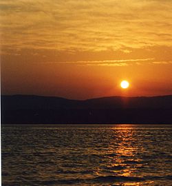 The sun sets over Deer Lake, Newfoundland, June 2003. | ||
| ||
 Deer Lake Location of Deer Lake in Newfoundland Show map of Newfoundland 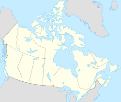 Deer Lake Deer Lake (Canada) Show map of Canada | ||
| Coordinates: 49°10′28″N 57°25′37″W / 49.17444°N 57.42694°W / 49.17444; -57.42694 | ||
| Country | Canada | |
| Province | Newfoundland and Labrador | |
| Census division | 5 | |
| Settled | 1864 | |
| Incorporated | 1950 | |
| Government | ||
| • Type | Liberal - M.H.A Dwight Ball | |
| • Mayor | Dean Ball | |
| Area | ||
| • Total | 73.23 km2 (28.27 sq mi) | |
| Elevation | 30 m (100 ft) | |
| Population (2016) | ||
| • Total | 5,249[1] | |
| • Density | 65.9/km2 (171/sq mi) | |
| Time zone | UTC-3:30 (Newfoundland Time) | |
| • Summer (DST) | UTC-2:30 (Newfoundland Daylight) | |
| Postal code span | A8A | |
| Area code(s) | 709 | |
| Highways | Route 1 | |
| Website | Official web site | |

Deer Lake is a town in the western part of the island of Newfoundland in the province of Newfoundland and Labrador, Canada.
The town derives its name from Deer Lake and is situated at the outlet of the upper Humber River at the northeastern end of the lake.
Contents
1 History
2 Economy
3 Sights and tourism
4 Demographics
5 Climate
6 Transport
7 Notable people
8 See also
9 References
10 External links
History

Deer Lake International Pulp and Paper Company staff house
The first settlers in the area arrived from Cape Breton Island in Nova Scotia in 1864. Originally loggers and trappers, the settlers later took up farming.
In 1922, a work camp was set up to support the International Pulp and Paper company. The camp would later become the town of Deer Lake. A formal townsite was constructed in 1925 and included a railroad terminal, churches and a small hospital. The town was incorporated in 1950.
The airport was built in 1955 and is one of the town's major employers. In 2004, Deer Lake Regional Airport began plans to redesign the airport terminal, completed in June 2007. The primary population that the airport serves is approximately 55,000. The effect was from Rocky Harbour to Corner Brook and around Deer Lake.
Economy

Deer Lake

Salvation Army

Hodder Memorial Recreational Complex
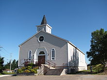
St. Paul's United Church
The town is located in Division No. 5 and is the gateway to the Great Northern Peninsula, owing to an important highway interchange on the Trans-Canada Highway. It is the closest major community to Gros Morne National Park and is home to the Deer Lake Regional Airport.
A hydroelectric plant was established on the Humber River in 1925 to provide electricity to a pulp and paper paper mill in Corner Brook.
Sights and tourism
Deer Lake offers accommodation for tourists as well as restaurants, supermarkets, convenience stores and gas stations. There is a stadium, swimming pool and a bowling alley in the Hodder Memorial Recreational Complex. St. Paul's United Church, a wooden church dating from 1955 and the modern Salvation Army building are worth a visit. The Main Street offers a scenic view of the lake.
Demographics
Population 2016: 5,249
Population 2011: 4,995[1]
Population, 2006: 4,827[2]
Population, 2001: 4,769
2006 to 2016 population change: 11.43 percent
Number of dwellings: 2,106
Land (square kilometers): 73.23
Climate
Deer Lake has a humid continental climate with moderately warm summers that are on the short side, with quite long and cold winters that are moderated by its proximity to a large body of water. With precipitation high year-round, Deer Lake receives plenty of snowfall in winters.
| Climate data for Deer Lake, Newfoundland and Labrador | |||||||||||||
|---|---|---|---|---|---|---|---|---|---|---|---|---|---|
| Month | Jan | Feb | Mar | Apr | May | Jun | Jul | Aug | Sep | Oct | Nov | Dec | Year |
| Record high °C (°F) | 16.5 (61.7) | 14.0 (57.2) | 19.0 (66.2) | 23.0 (73.4) | 28.0 (82.4) | 33.0 (91.4) | 35.6 (96.1) | 32.2 (90.0) | 29.0 (84.2) | 23.3 (73.9) | 21.1 (70.0) | 16.7 (62.1) | 35.6 (96.1) |
| Average high °C (°F) | −3.1 (26.4) | −3.4 (25.9) | 0.7 (33.3) | 6.3 (43.3) | 12.9 (55.2) | 18.0 (64.4) | 21.9 (71.4) | 21.6 (70.9) | 17.0 (62.6) | 10.4 (50.7) | 4.6 (40.3) | 0.0 (32.0) | 8.9 (48.0) |
| Daily mean °C (°F) | −7.2 (19.0) | −8.0 (17.6) | −4.1 (24.6) | 1.9 (35.4) | 7.4 (45.3) | 12.2 (54.0) | 16.5 (61.7) | 16.4 (61.5) | 12.3 (54.1) | 6.6 (43.9) | 1.5 (34.7) | −3.3 (26.1) | 4.4 (39.8) |
| Average low °C (°F) | −11.2 (11.8) | −12.7 (9.1) | −8.8 (16.2) | −2.5 (27.5) | 1.9 (35.4) | 6.4 (43.5) | 11.0 (51.8) | 11.3 (52.3) | 7.5 (45.5) | 2.7 (36.9) | −1.6 (29.1) | −6.6 (20.1) | −0.2 (31.6) |
| Record low °C (°F) | −33.9 (−29.0) | −37.2 (−35.0) | −35.0 (−31.0) | −22.0 (−7.6) | −10.6 (12.9) | −4.4 (24.1) | −0.6 (30.9) | −2.2 (28.0) | −5.0 (23.0) | −10.5 (13.1) | −20.6 (−5.1) | −29.4 (−20.9) | −37.2 (−35.0) |
| Average precipitation mm (inches) | 109.8 (4.32) | 83.5 (3.29) | 71.7 (2.82) | 70.1 (2.76) | 89.2 (3.51) | 88.3 (3.48) | 98.5 (3.88) | 109.9 (4.33) | 106.2 (4.18) | 105.7 (4.16) | 101.3 (3.99) | 97.3 (3.83) | 1,131.5 (44.55) |
| Average rainfall mm (inches) | 24.8 (0.98) | 17.3 (0.68) | 27.5 (1.08) | 49.8 (1.96) | 84.3 (3.32) | 87.8 (3.46) | 98.5 (3.88) | 109.9 (4.33) | 106.2 (4.18) | 101.0 (3.98) | 74.8 (2.94) | 35.6 (1.40) | 817.5 (32.19) |
| Average snowfall cm (inches) | 85.0 (33.5) | 66.1 (26.0) | 44.2 (17.4) | 20.3 (8.0) | 4.8 (1.9) | 0.5 (0.2) | 0 (0) | 0 (0) | 0 (0) | 4.8 (1.9) | 26.6 (10.5) | 61.7 (24.3) | 314 (123.7) |
| Average precipitation days (≥ 0.2 mm) | 19.3 | 16.0 | 15.1 | 13.0 | 15.4 | 13.9 | 15.1 | 15.4 | 16.0 | 18.9 | 17.4 | 20.4 | 195.9 |
| Average rainy days (≥ 0.2 mm) | 2.7 | 2.9 | 5.6 | 9.5 | 15.0 | 13.9 | 15.1 | 15.4 | 16.0 | 18.7 | 12.6 | 6.8 | 134.2 |
| Average snowy days (≥ 0.2 cm) | 16.7 | 14.0 | 10.6 | 4.6 | 0.83 | 0.04 | 0 | 0 | 0 | 0.75 | 6.2 | 15.7 | 69.42 |
| Source: Environment Canada [3] | |||||||||||||
Transport
The community is served by Deer Lake Regional Airport, which is the nearest airport to Corner Brook and the most busy in the western part of the island.
Notable people
Dwight Ball, 13th Premier of Newfoundland and Labrador
Darren Langdon, National Hockey League player
See also
- List of cities and towns in Newfoundland and Labrador
References
^ ab "Census Profile"..mw-parser-output cite.citation{font-style:inherit}.mw-parser-output .citation q{quotes:"""""""'""'"}.mw-parser-output .citation .cs1-lock-free a{background:url("//upload.wikimedia.org/wikipedia/commons/thumb/6/65/Lock-green.svg/9px-Lock-green.svg.png")no-repeat;background-position:right .1em center}.mw-parser-output .citation .cs1-lock-limited a,.mw-parser-output .citation .cs1-lock-registration a{background:url("//upload.wikimedia.org/wikipedia/commons/thumb/d/d6/Lock-gray-alt-2.svg/9px-Lock-gray-alt-2.svg.png")no-repeat;background-position:right .1em center}.mw-parser-output .citation .cs1-lock-subscription a{background:url("//upload.wikimedia.org/wikipedia/commons/thumb/a/aa/Lock-red-alt-2.svg/9px-Lock-red-alt-2.svg.png")no-repeat;background-position:right .1em center}.mw-parser-output .cs1-subscription,.mw-parser-output .cs1-registration{color:#555}.mw-parser-output .cs1-subscription span,.mw-parser-output .cs1-registration span{border-bottom:1px dotted;cursor:help}.mw-parser-output .cs1-ws-icon a{background:url("//upload.wikimedia.org/wikipedia/commons/thumb/4/4c/Wikisource-logo.svg/12px-Wikisource-logo.svg.png")no-repeat;background-position:right .1em center}.mw-parser-output code.cs1-code{color:inherit;background:inherit;border:inherit;padding:inherit}.mw-parser-output .cs1-hidden-error{display:none;font-size:100%}.mw-parser-output .cs1-visible-error{font-size:100%}.mw-parser-output .cs1-maint{display:none;color:#33aa33;margin-left:0.3em}.mw-parser-output .cs1-subscription,.mw-parser-output .cs1-registration,.mw-parser-output .cs1-format{font-size:95%}.mw-parser-output .cs1-kern-left,.mw-parser-output .cs1-kern-wl-left{padding-left:0.2em}.mw-parser-output .cs1-kern-right,.mw-parser-output .cs1-kern-wl-right{padding-right:0.2em}
^ Population and dwelling counts
^ http://climate.weather.gc.ca/climate_normals/results_1981_2010_e.html?stnID=6614&lang=e&province=NL&provSubmit=go&dCode=0
External links
| Wikimedia Commons has media related to Deer Lake, Newfoundland and Labrador. |
- Official web site
- Deer Lake - Encyclopedia of Newfoundland and Ladrador, vol. 1, p. 608-609.
Division No. 5, Newfoundland and Labrador (Humber District) | ||
|---|---|---|
| Cities |
|  |
| Towns |
| |
| Unorganized subdivisions |
| |
| ||
| |
| Census divisions |
|
| Cities |
|
| Other communities |
|
| |
Coordinates: 49°10′28″N 57°25′37″W / 49.17444°N 57.42694°W / 49.17444; -57.42694
Authority control |
|
|---|


