慕尼黑长途汽车总站
body.skin-minerva .mw-parser-output table.infobox caption{text-align:center}
慕尼黑长途汽车总站 ZOB München | |||
|---|---|---|---|
 | |||
| 位置 | 慕尼黑 马克斯近郊 | ||
| 地理坐标 | 48°08′33″N 11°33′00″E / 48.14250°N 11.55000°E / 48.14250; 11.55000坐标:48°08′33″N 11°33′00″E / 48.14250°N 11.55000°E / 48.14250; 11.55000 | ||
| 车站类别 | 长途客车 | ||
| 其他信息 | |||
| 历史 | |||
| 启用日期 | 2009年9月11日 (2009-09-11) | ||
| 服务 | |||
| |||

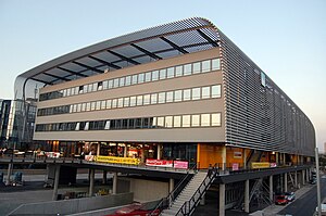
2011年时的慕尼黑汽车总站
慕尼黑长途汽车总站(德語:Zentraler Omnibusbahnhof München,一般使用其简称ZOB München)顾名思义是慕尼黑最大地理位置最为中心的长途汽车站,位于马克斯近郊。该汽车站占地17,221平方米(185,370平方英尺),于2009年9月11日建成,是慕尼黑最大的国际/国内汽车站。弗利克斯巴士、欧洲之线巴士和你的巴士线路均停靠此站,并在此设有客户服务中心。该车站附近有快轨站黑客桥站。
| 这是一篇與交通相關的小作品。你可以通过编辑或修订扩充其内容。 |


