Saône-et-Loire
This article includes a list of references, related reading or external links, but its sources remain unclear because it lacks inline citations. (February 2018) (Learn how and when to remove this template message) |
Saône-et-Loire | |||
|---|---|---|---|
Department | |||
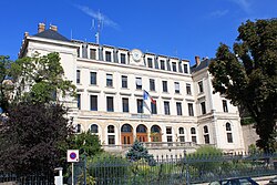 Prefecture building of the Saône-et-Loire department, in Mâcon | |||
| |||
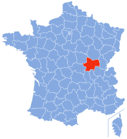 Location of Saône-et-Loire in France | |||
| Coordinates: 46°40′N 04°42′E / 46.667°N 4.700°E / 46.667; 4.700Coordinates: 46°40′N 04°42′E / 46.667°N 4.700°E / 46.667; 4.700 | |||
| Country | France | ||
| Region | Bourgogne-Franche-Comté | ||
| Prefecture | Mâcon | ||
| Subprefectures | Autun Chalon-sur-Saône Charolles Louhans | ||
| Government | |||
| • President of the General Council | André Accary | ||
| Area 1 | |||
| • Total | 8,575 km2 (3,311 sq mi) | ||
| Population (2013) | |||
| • Total | 556,222 | ||
| • Rank | 47th | ||
| • Density | 65/km2 (170/sq mi) | ||
| Time zone | UTC+1 (CET) | ||
| • Summer (DST) | UTC+2 (CEST) | ||
| Department number | 71 | ||
| Arrondissements | 5 | ||
| Cantons | 29 | ||
| Communes | 567 | ||
^1 French Land Register data, which exclude estuaries, and lakes, ponds, and glaciers larger than 1 km2 | |||

Saône-et-Loire (French pronunciation: [sonelwaʁ]; Arpitan: Sona-et-Lêre) is a French department, named after the Saône and the Loire rivers between which it lies.
Contents
1 History
2 Geography
2.1 Principal towns
3 Subdivisions
4 Tourism
5 See also
6 References
7 External links
History
When it was formed during the French Revolution, as of March 4, 1790 in fulfillment of the law of December 22, 1789, the new department combined parts of the provinces of southern Burgundy and Bresse, uniting lands that had no previous common history nor political unity and which have no true geographical unity. Thus its history is that of Burgundy, and is especially to be found in the local histories of Autun, Mâcon, Chalon-sur-Saône, Charolles and Louhans.
Geography
Saône-et-Loire is the seventh largest department of France. It is part of the region Bourgogne-Franche-Comté. In the west, the department is composed of the hills of the Autunois, the region around Autun, in the southwest the Charollais, and the Mâconnais in the south.
In the centre, the department is traversed from north to south by the Saône in its wide plain; the Saône is a tributary of the River Rhône that joins it at Lyon and thus is connected to the Mediterranean Sea. The source of the Loire, is south of the department, in the department of Ardèche. It then makes its way in the opposite direction, forming the southwest border of the department, and eventually draining into the Atlantic Ocean. The Canal du Centre links the Saône to the Loire between Chalon-sur-Saône and Digoin, thereby linking the Mediterranean Sea to the Atlantic ocean. In the east, the department occupies the northern part of the plain of Bresse. In the west, its industrial heart is in Le Creusot and Montceau-les-Mines, formerly noted for their coal mines and metallurgy.
Principal towns
| Rank | Commune | Canton | Arrondissement | Population |
|---|---|---|---|---|
| 1 | Chalon-sur-Saône | Chalon-sur-Saône-1 Chalon-sur-Saône-2 Chalon-sur-Saône-3 | Chalon-sur-Saône | 45,166 |
| 2 | Mâcon | Mâcon-1 Mâcon-2 | Mâcon | 33,350 |
| 3 | Le Creusot | Le Creusot-1 Le Creusot-2 | Autun | 22,308 |
| 4 | Montceau-les-Mines | Montceau-les-Mines | Chalon-sur-Saône | 18,969 |
| 5 | Autun | Autun-1 Autun-2 | Autun | 13,863 |
Subdivisions
The department consists of five arrondissements:
- Autun
- Chalon-sur-Saône
- Charolles
- Louhans
- Mâcon
There are 29 cantons in the department and 567 communes.

Tourism
Touristic sites :
Roche de Solutré,
Charolles,
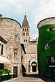
Abbaye de Cluny,
Taizé and Taizé Community
Dompierre-les-Ormes (Galerie européenne de la forêt et du bois, Arboretum de Pézanin).
Lamartine's statue in Mâcon

Temple of Janus in Autun
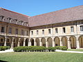
Cluny Abbey

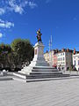
Chalon-sur-Saône
Tournus

Lake of Pézanin


See also
Mâcon - Capital- Cantons of the Saône-et-Loire department
- Communes of the Saône-et-Loire department
- Arrondissements of the Saône-et-Loire department
- Chizerots
References
^ "Insee - Populations légales 2013". Insee. Retrieved September 11, 2016..mw-parser-output cite.citation{font-style:inherit}.mw-parser-output q{quotes:"""""""'""'"}.mw-parser-output code.cs1-code{color:inherit;background:inherit;border:inherit;padding:inherit}.mw-parser-output .cs1-lock-free a{background:url("//upload.wikimedia.org/wikipedia/commons/thumb/6/65/Lock-green.svg/9px-Lock-green.svg.png")no-repeat;background-position:right .1em center}.mw-parser-output .cs1-lock-limited a,.mw-parser-output .cs1-lock-registration a{background:url("//upload.wikimedia.org/wikipedia/commons/thumb/d/d6/Lock-gray-alt-2.svg/9px-Lock-gray-alt-2.svg.png")no-repeat;background-position:right .1em center}.mw-parser-output .cs1-lock-subscription a{background:url("//upload.wikimedia.org/wikipedia/commons/thumb/a/aa/Lock-red-alt-2.svg/9px-Lock-red-alt-2.svg.png")no-repeat;background-position:right .1em center}.mw-parser-output .cs1-subscription,.mw-parser-output .cs1-registration{color:#555}.mw-parser-output .cs1-subscription span,.mw-parser-output .cs1-registration span{border-bottom:1px dotted;cursor:help}.mw-parser-output .cs1-hidden-error{display:none;font-size:100%}.mw-parser-output .cs1-visible-error{font-size:100%}.mw-parser-output .cs1-subscription,.mw-parser-output .cs1-registration,.mw-parser-output .cs1-format{font-size:95%}.mw-parser-output .cs1-kern-left,.mw-parser-output .cs1-kern-wl-left{padding-left:0.2em}.mw-parser-output .cs1-kern-right,.mw-parser-output .cs1-kern-wl-right{padding-right:0.2em}
External links
(in French) General Council website
(in French) Prefecture website
(in English) Saone-et-Loire at Curlie
Authority control |
|
|---|


