昭拍耶河
body.skin-minerva .mw-parser-output table.infobox caption{text-align:center}
| 昭拍耶河 | |
|---|---|
 湄南河曼谷段 | |
 | |
| 流域 | |
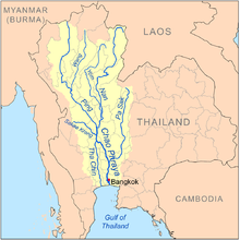
| 源头 | 滨河和楠河的汇流 |
| 河口 | 泰国湾 |
| 面積 | 160,000 km² (141,398 mi²) |
| 流經国家 | |
| 本貌 | |
| 長度 | 372 km (231 mi) |
| 平均流量 | 883 m³/s |
昭拍耶河(泰語:แม่น้ำเจ้าพระยา, Maenam Chao Phraya),而潮州話常稱為湄南河,是泰國最主要的河流。泰语「湄南」(แม่น้ำ),是潮州人的誤稱,直譯為:「水之母」,即河流;「昭拍耶」(เจ้าพระยา)在泰语的河名,意思是泰國古代的軍階,等於九品中正制的第二品,河流名字即大王河。它發源於泰北山地,而名稱為「昭拍耶」的河段則从滨河、楠河及永河的交汇处那空沙旺附近开始,向南流约40公里左右,到猜纳附近分为两支,西支叫他真河,东支即昭拍耶河。穿過曼谷直到暹羅灣。无论在水量抑或长度,昭拍耶河都是泰国最大的河流。
昭拍耶河是东南亚最大的河流之一,全长1352公里(从滨河河源起算至出海口),在北曼谷地方寬度能達到700-800米(雨季時),流域面积为150,000平方公里,约占泰国国土面积的三分之一。
昭拍耶河流域是泰国耕地集中的地区。昭拍耶河的水量随季节而急剧变化,旱季、雨季的流量相差达十多倍。干季时流量仅150立方米每秒(m3{displaystyle m^{3}}
昭拍耶河下游平原面积广阔,约达5万平方公里。这里河汊交错,气候炎热,雨量充沛,河流定期泛滥,土地肥沃,多數地區適合種植稻米四造,被譽為「泰國糧倉」,特别是经过泰国人民的辛勤劳动,稻米產量達到世界之冠。這裡已發展成為泰國人口最集中、經濟最發達的地區。
主要支流
以下由河口至源頭列出主要支流:
- 昭拍耶河
帕薩克河 (แม่น้ำป่าสัก)
撒該甘河 (แม่น้ำสะแกกรัง)
楠河 (แม่น้ำน่าน)
永河 (แม่น้ำยม)
滨河 (แม่น้ำปิง)
汪河 (แม่น้ำวัง)
维基共享资源中相关的多媒体资源:昭拍耶河 |
| 这是一篇與亚洲相關的地理小作品。你可以通过编辑或修订扩充其内容。 |
坐标:13°32′25″N 100°35′23″E / 13.54028°N 100.58972°E / 13.54028; 100.58972


