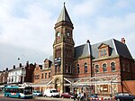
Southport Eastbank Street railway station
| Southport Eastbank Street | |
|---|---|
 Although the station closed in 1851, the station master's house and ticket office still stand adjacent to the level crossing on Portland Street. | |
| Location | |
| Place | Southport |
| Area | Metropolitan Borough of Sefton |
| Coordinates | 53°38′30″N 3°00′11″W / 53.6418°N 3.0031°W / 53.6418; -3.0031Coordinates: 53°38′30″N 3°00′11″W / 53.6418°N 3.0031°W / 53.6418; -3.0031 |
| Grid reference | SD336166 |
| Operations | |
| Original company | Liverpool, Crosby and Southport Railway |
| Pre-grouping | Liverpool, Crosby and Southport Railway |
| History | |
| 21 July 1848 | Opened |
| 22 August 1851 | Closed |
| Disused railway stations in the United Kingdom | |
| Closed railway stations in Britain A B C D–F G H–J K–L M–O P–R S T–V W–Z | |
Southport Eastbank Street was a railway station in Southport, Merseyside.
History
The station opened on 21 July 1848 as the temporary northern terminus of the Liverpool, Crosby and Southport Railway, and was the first railway station in Southport. Situated between Eastbank Street and Portland Street, it consisted of a single platform together with a run-round loop and one siding. In 1850 the platform was extended, and an extra line was constructed along with two additional sidings on the east side. The station closed on 22 August 1851, following the completion of a permanent terminal station at Chapel Street, though the line remains open and is today used by trains on the Merseyrail Northern Line. The only remaining traces of the station are the station master's house and a ticket office, adjacent to the level crossing on Portland Street.
The house is now let to Southport Model Railway Society.
References
Gahan, John W. (1985). Seaport to Seaside. Countyvise Limited. pp. 21, 91. ISBN 0-907768-07-5..mw-parser-output cite.citation{font-style:inherit}.mw-parser-output q{quotes:"""""""'""'"}.mw-parser-output code.cs1-code{color:inherit;background:inherit;border:inherit;padding:inherit}.mw-parser-output .cs1-lock-free a{background:url("//upload.wikimedia.org/wikipedia/commons/thumb/6/65/Lock-green.svg/9px-Lock-green.svg.png")no-repeat;background-position:right .1em center}.mw-parser-output .cs1-lock-limited a,.mw-parser-output .cs1-lock-registration a{background:url("//upload.wikimedia.org/wikipedia/commons/thumb/d/d6/Lock-gray-alt-2.svg/9px-Lock-gray-alt-2.svg.png")no-repeat;background-position:right .1em center}.mw-parser-output .cs1-lock-subscription a{background:url("//upload.wikimedia.org/wikipedia/commons/thumb/a/aa/Lock-red-alt-2.svg/9px-Lock-red-alt-2.svg.png")no-repeat;background-position:right .1em center}.mw-parser-output .cs1-subscription,.mw-parser-output .cs1-registration{color:#555}.mw-parser-output .cs1-subscription span,.mw-parser-output .cs1-registration span{border-bottom:1px dotted;cursor:help}.mw-parser-output .cs1-hidden-error{display:none;font-size:100%}.mw-parser-output .cs1-visible-error{font-size:100%}.mw-parser-output .cs1-subscription,.mw-parser-output .cs1-registration,.mw-parser-output .cs1-format{font-size:95%}.mw-parser-output .cs1-kern-left,.mw-parser-output .cs1-kern-wl-left{padding-left:0.2em}.mw-parser-output .cs1-kern-right,.mw-parser-output .cs1-kern-wl-right{padding-right:0.2em}, and Avon Anglia Publications,
ISBN 0-905466-73-X.
Gell, Rob (1986). An Illustrated Survey of Railway Stations Between Southport & Liverpool 1848-1986. Heyday Publishing Company. ISBN 0-947562-04-4.
This article on a railway station in Merseyside is a stub. You can help Wikipedia by expanding it. |


