塔村區
塔村區 London Borough of Tower Hamlets | |
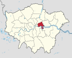 塔村區在大倫敦的位置 | |
| 地理 | |
|---|---|
行政狀態 | 倫敦自治市 |
面積 — 總 | 第348名 19.77km² |
ONS | 00BG |
行政總部 | Clove Crescent, Blackwallt |
| 人口統計(mid-2016 est.) | |
| 人口排名 總人口 人口密度 | (共354區) 12034/km² |
種族 英國白人 愛爾蘭人 其他白人 白人-加勒比海黑人 白人-加勒比海非裔 亞裔白人 其他混血兒 印度人 巴基斯坦人 孟加拉人 其他亞裔 加勒比海黑人 非裔黑人 其他黑人 英籍华人 其他 | (2005年估計)[1] 44.2% 1.8% 7.9% 0.8% 0.4% 0.8% 0.6% 2.1% 1.0% 30.5% 1.0% 2.2% 2.8% 0.5% 2.3% 1.2% |
| 政治 | |
| 塔村區的倫敦自治市議會 | |
塔村區的倫敦自治市議會標誌 | |
領導 | Leader & Cabinet |
市長 | Shafiqul Haque |
立法 | Executive Mayor: Tower Hamlets First |
議員 | Jim Fitzpatrick George Galloway |
倫敦議會 — 成員 | 倫敦市與東區 John Biggs |
紋章 | |
塔村區議會紋章 | |
網站 | Towerhamlets.gov.uk |
塔村區(英语:London Borough of Tower Hamlets,![]() .mw-parser-output .IPA{font-family:"Charis SIL","Doulos SIL","Linux Libertine","Segoe UI","Lucida Sans Unicode","Code2000","Gentium","Gentium Alternative","TITUS Cyberbit Basic","Arial Unicode MS","IPAPANNEW","Chrysanthi Unicode","GentiumAlt","Bitstream Vera","Bitstream Cyberbit","Hiragino Kaku Gothic Pro","Lucida Grande",sans-serif;text-decoration:none!important}.mw-parser-output .IPA a:link,.mw-parser-output .IPA a:visited{text-decoration:none!important}
.mw-parser-output .IPA{font-family:"Charis SIL","Doulos SIL","Linux Libertine","Segoe UI","Lucida Sans Unicode","Code2000","Gentium","Gentium Alternative","TITUS Cyberbit Basic","Arial Unicode MS","IPAPANNEW","Chrysanthi Unicode","GentiumAlt","Bitstream Vera","Bitstream Cyberbit","Hiragino Kaku Gothic Pro","Lucida Grande",sans-serif;text-decoration:none!important}.mw-parser-output .IPA a:link,.mw-parser-output .IPA a:visited{text-decoration:none!important}
/lʌndən bʌɹə ɒv ˈtaʊə ˌhæmlɪts/ 帮助·信息),意為“倫敦塔”(Tower)外的“村落”(Hamlets),是英國英格蘭大倫敦內倫敦的自治市,人口212,800,面積19.77 km²。
目录
1 簡介
2 人口
3 景點
4 注釋
5 外部連結
簡介
轄區鄰近倫敦市,屬商業區之一。在十九世紀至二十世紀中,轄區曾是倫敦對外貿易中心。自1960年代航運業衰頹,轄區逐漸轉型,成為金融中心區。
人口
轄區從十九世紀起,隨著對外貿易發展人口不斷上升。至1940年代人口共有489,956人[2]。然而在航運業衰微後,目前人口比高峰期少了約一半。
景點
金丝雀码头(Canary Wharf)- 倫敦匯豐銀行總部
注釋
^ Data Management and Analysis Group, Greater London Authority, Demography Update October 2007, (2007)
^ Tower Hamlets: Total Population. A Vision of Britain Through Time. Great Britain Historical GIS Project. [2011-09-06].
外部連結
(英文)塔村區 政府網
| ||||||||||
坐标:51°31′N 0°03′W / 51.517°N 0.050°W / 51.517; -0.050


