Gir Somnath district

Multi tool use
‹ The template Infobox settlement is being considered for merging. ›
district in Gujarat, India
Gir Somnath district |
district |
 Location of district in Gujarat
|
Country |
India
|
State |
Gujarat |
Region |
Saurashtra |
Headquarters |
Veraval |
Area [1]
|
• Total |
3,755 km2 (1,450 sq mi) |
Population (2011[1])
|
• Total |
946,790 |
• Density |
250/km2 (650/sq mi) |
Languages
|
• Official |
Gujarati, Hindi, English
|
Time zone |
UTC+5:30 (IST) |
Vehicle registration |
GJ 32 |
Website |
gujaratindia.com |
Gir Somnath District is a district of Gujarat, India. It is located on the southern corner of the Kathiawar peninsula with its headquarters at the town of Veraval. Veraval has a population around 3.5 lacs.
Gir Somnath District was split from Junagadh district in August 2013, when seven new districts came into existence in Gujarat.[2][3]
Patan-Veraval, Talala, Sutrapada, Kodinar, Una and Gir-Gadhada are the talukas of Gir Somnath District.[4]
The Gir Forest is a home of many wildlife creatures including lions, deer, and monkeys. Asiatic Lions can be only be found in the Gir Forest.[4]

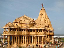
The famed Somnath temple, a Hindu pilgrimage sites is located in Gir Somnath District
See also
- Somnath temple
- Veraval
- Delwada
- Veraval Chowpati
- Sasan Gir
Notes and references
^ ab Industrial Potentiality Survey Report of Gir Somnath District [2016-17
^ "Promises Delivered! Gujarat Cabinet approves creation of 7 New Districts and 22 New Talukas". Narendra Modi. 25 January 2013. Archived from the original on 15 April 2015..mw-parser-output cite.citation{font-style:inherit}.mw-parser-output .citation q{quotes:"""""""'""'"}.mw-parser-output .citation .cs1-lock-free a{background:url("//upload.wikimedia.org/wikipedia/commons/thumb/6/65/Lock-green.svg/9px-Lock-green.svg.png")no-repeat;background-position:right .1em center}.mw-parser-output .citation .cs1-lock-limited a,.mw-parser-output .citation .cs1-lock-registration a{background:url("//upload.wikimedia.org/wikipedia/commons/thumb/d/d6/Lock-gray-alt-2.svg/9px-Lock-gray-alt-2.svg.png")no-repeat;background-position:right .1em center}.mw-parser-output .citation .cs1-lock-subscription a{background:url("//upload.wikimedia.org/wikipedia/commons/thumb/a/aa/Lock-red-alt-2.svg/9px-Lock-red-alt-2.svg.png")no-repeat;background-position:right .1em center}.mw-parser-output .cs1-subscription,.mw-parser-output .cs1-registration{color:#555}.mw-parser-output .cs1-subscription span,.mw-parser-output .cs1-registration span{border-bottom:1px dotted;cursor:help}.mw-parser-output .cs1-ws-icon a{background:url("//upload.wikimedia.org/wikipedia/commons/thumb/4/4c/Wikisource-logo.svg/12px-Wikisource-logo.svg.png")no-repeat;background-position:right .1em center}.mw-parser-output code.cs1-code{color:inherit;background:inherit;border:inherit;padding:inherit}.mw-parser-output .cs1-hidden-error{display:none;font-size:100%}.mw-parser-output .cs1-visible-error{font-size:100%}.mw-parser-output .cs1-maint{display:none;color:#33aa33;margin-left:0.3em}.mw-parser-output .cs1-subscription,.mw-parser-output .cs1-registration,.mw-parser-output .cs1-format{font-size:95%}.mw-parser-output .cs1-kern-left,.mw-parser-output .cs1-kern-wl-left{padding-left:0.2em}.mw-parser-output .cs1-kern-right,.mw-parser-output .cs1-kern-wl-right{padding-right:0.2em}
^ "Maps of Gujarat's new 7 districts and changes in existing districts". Desh Gujarat. 13 August 2013. Archived from the original on 16 August 2013.
^ ab About Gir Somnath - Collectorate - District Gir Somnath
Places adjacent to Gir Somnath district |
Junagadh district |
Junagadh district |
Amreli district |
Arabian Sea |
Gir Somnath district
|
Amreli district |
Arabian Sea |
Diu district, Daman and Diu
|
Gulf of Khambhat |
|
 State of Gujarat
|
Capital: Gandhinagar
|
Topics |
- Cinema
- Cuisine
- Culture
- Economy
- Education
- Geography
- Government
- Highest point
- History
- Language
- Literature
- People
- Politics
- National parks and sanctuaries
- Tourism
|
|
Regions of Gujarat |
- Kutch
- Saurashtra
- North Gujarat
- Central Gujarat
- South Gujarat
|
Districts |
- Ahmedabad
- Amreli
- Anand
- Aravalli
- Banaskantha
- Bharuch
- Bhavnagar
- Botad
- Chhota Udaipur
- Dahod
- Dang
- Devbhoomi Dwarka
- Gandhinagar
- Gir Somnath
- Jamnagar
- Junagadh
- Kachchh
- Kheda
- Mahisagar
- Mehsana
- Morbi
- Narmada
- Navsari
- Panchmahal
- Patan
- Porbandar
- Rajkot
- Sabarkantha
- Surat
- Surendranagar
- Tapi
- Vadodara
- Valsad
|
Major cities
|
- Ahmedabad
- Anand
- Ankleshwar
- Bharuch
- Bhavnagar
- Bhuj
- Gandhidham
- Gandhinagar
- Jamnagar
- Junagadh
- Kheda
- Mehsana
- Nadiad
- Navsari
- Modasa
- Patan
- Porbandar
- Rajkot
- Surat
- Surendranagar
- Udhana
- Vadodara
- Valsad
- Vapi
- Veraval
- Visnagar
|
Ecoregions |
- Indus River Delta-Arabian Sea mangroves
- Khathiar-Gir dry deciduous forests
- North Western Ghats moist deciduous forests
- Northwestern thorn scrub forests
- Rann of Kutch
|
Economy |
- Ahmedabad Bus Rapid Transit System
- Gujarat International Finance Tec-City
- Sabarmati Riverfront
- Sardar Sarovar Dam
- GSWAN
- Power stations and power organisations
Gujarat State Petroleum Corporation
|
|
a5dcCY14d5 lq7golr61tuwSaBZAil,k1kJInzvI3qwi7gg4RI8hnhaL,o wy cTUqz
Popular posts from this blog
This article is about the letter of the alphabet. For other uses, see Y (disambiguation). See also: Wye (disambiguation) Y Y y (See below) Usage Writing system Latin script Type Alphabetic and Logographic Language of origin Latin language Phonetic usage [ y ] [ ɨ ] [ j ] [ iː ] [ ɪ ] [ ɘ ] [ ə ] [ ɯ ] [ ɛː ] [ j ] [ ɥ ] [ ɣ̟ ] / w aɪ / / aɪ / Unicode value U+0059, U+0079 Alphabetical position 25 History Development Υ υ 𐌖 Y y Time period 54 to present Descendants • U • V • W • Ỿ • ¥ • Ꮙ • Ꮍ • Ꭹ Sisters F Ѵ У Ў Ұ Ү ו و ܘ וּ וֹ ࠅ 𐎆 𐡅 ወ વ ૂ ુ उ Variations (See below) Other Other letters commonly used with y(x), ly, ny This article contains IPA phonetic symbols. Without proper rendering support, you may see question marks, boxes, or other symbols instead of Unicode characters. For an introductory guide on IPA symbols, see Help:IPA. ISO basic Latin alphabet Aa Bb Cc D...
Mount Tamalpais Mount Tamalpais, viewed from the south Highest point Elevation 2,571 ft (784 m) NAVD 88 [1] Prominence 2,456 ft (749 m) [1] Listing California county high points 55th Coordinates 37°55′45″N 122°34′40″W / 37.929088°N 122.577829°W / 37.929088; -122.577829 Coordinates: 37°55′45″N 122°34′40″W / 37.929088°N 122.577829°W / 37.929088; -122.577829 [1] Geography Mount Tamalpais Marin County, California, U.S. Show map of California Mount Tamalpais Mount Tamalpais (the US) Show map of the US Parent range California Coast Ranges Topo map USGS San Rafael Geology Mountain type Sedimentary Climbing First ascent 1830s by Jacob P. Leese (first recorded ascent) [2] Easiest route Railroad Grade fire trail Mount Tamalpais ( / t æ m əl ˈ p aɪ . ɪ s / ; TAM -əl- PY -iss ; Coast Miwok: /t̪ɑmɑlˈpɑis̺/ , known locally as Mount Tam ) is a peak in Marin County, California, United State...
FMW Women's Championship Details Promotion Frontier Martial-Arts Wrestling [1] Date established November 5, 1990 [1] Date retired September 28, 1997 Other name(s) WWA World Women's Championship FMW Independent Women's Championship Statistics First champion(s) Combat Toyoda [1] Most reigns Megumi Kudo (6 reigns) [1] Longest reign Megumi Kudo (426 days) [1] Shortest reign Shark Tsuchiya (<1 day) [1] The FMW Women's Championship (or the FMW Independent Women's & WWA Women's Championship ) was two Japanese women's professional wrestling championships (WWA World Women's Championship and FMW Independent World Women's Championship) contested in the promotion Frontier Martial-Arts Wrestling (FMW). During the heyday of FMW, the female wrestlers wrestled in the same types of bloody death matches as the FMW men, and were feared by other Japanese female wrestlers for their toughness and intensity. ...