Complex volcano

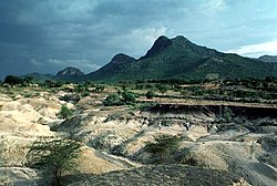
Homa Mountain, Kenya in 1994

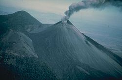
An eruption of Pacaya, Guatemala in 1976

Mt. Banahaw, Luzon, Philippines in 1989

Kelimutu, Flores, Indonesia
A complex volcano, also called a compound volcano, is mixed landform consisting of related volcanic centers and their associated lava flows and pyroclastic rock.[1] They may form due to changes in eruptive habit or in the location of the principal vent area on a particular volcano.[2] Stratovolcanoes can also form a large caldera that gets filled in by a lava dome, or else multiple small cinder cones, lava domes and craters may develop on the caldera's rim.[2][3]
Although a comparatively unusual type of volcano, they are widespread in the world and in geologic history. Metamorphosed ash flow tuffs are widespread in the Precambrian rocks of northern New Mexico, which indicates that caldera complexes have been important for much of Earth's history. Yellowstone National Park is on three partly covered caldera complexes. The Long Valley Caldera in eastern California is also a complex volcano; the San Juan Mountains in southwestern Colorado are formed on a group of Neogene-age caldera complexes, and most of the Mesozoic and Cenozoic rocks of Nevada, Idaho, and eastern California are also caldera complexes and their erupted ash flow tuffs. The Bennett Lake Caldera in British Columbia and the Yukon Territory is another example of a Cenozoic (Eocene) caldera complex.
Examples
Akita-Yake-Yama (Honshū, Japan)
Asacha (Kamchatka Peninsula, Russia)
Asama (Honshū, Japan)
Kusatsu-Shirane (Kusatsu, Gunma, Japan)
Banahaw (Luzon, Philippines)
Bennett Lake Caldera (British Columbia/Yukon, Canada)
Mount Edziza volcanic complex (British Columbia, Canada)
Galeras (Colombia, South America)
Grozny Group (Kuril Islands, Russia)
Hakone (Japan)
Homa Mountain (Kenya)
Irazú Volcano (Costa Rica)
Ischia (Italy)
Kelimutu (Flores, Indonesia)
Las Pilas (Nicaragua)
Long Valley Caldera (California, United States)
McDonald Islands (Indian Ocean, Australia)
Mount Meager massif (British Columbia, Canada)
Morne Trois Pitons (Dominica)
Mundua (New Britain, Papua New Guinea)
Pacaya (Guatemala)
Puyehue-Cordón Caulle (Chile)
Rincón de la Vieja Volcano (Costa Rica)
Silverthrone Caldera (British Columbia, Canada)
St. Andrew Strait (Admiralty Islands, Papua New Guinea)
Taal Volcano, (Batangas, Philippines)
Mount Talinis, (Negros Oriental, Philippines)
Three Sisters (Oregon) (Oregon, United States)[2]
Te Tatua-a-Riukiuta (Auckland, New Zealand)
Tongariro, (New Zealand)
Valles Caldera (New Mexico, United States)
Whale Island (New Zealand)
Yellowstone Caldera (Wyoming, United States)
See also
Volcanic group – A collection of related volcanoes or volcanic landforms
References
^ "Dieng Volcanic Complex – Volcano World – Oregon State University". volcano.oregonstate.edu. Oregon State University. Retrieved 2016-03-21..mw-parser-output cite.citation{font-style:inherit}.mw-parser-output .citation q{quotes:"""""""'""'"}.mw-parser-output .citation .cs1-lock-free a{background:url("//upload.wikimedia.org/wikipedia/commons/thumb/6/65/Lock-green.svg/9px-Lock-green.svg.png")no-repeat;background-position:right .1em center}.mw-parser-output .citation .cs1-lock-limited a,.mw-parser-output .citation .cs1-lock-registration a{background:url("//upload.wikimedia.org/wikipedia/commons/thumb/d/d6/Lock-gray-alt-2.svg/9px-Lock-gray-alt-2.svg.png")no-repeat;background-position:right .1em center}.mw-parser-output .citation .cs1-lock-subscription a{background:url("//upload.wikimedia.org/wikipedia/commons/thumb/a/aa/Lock-red-alt-2.svg/9px-Lock-red-alt-2.svg.png")no-repeat;background-position:right .1em center}.mw-parser-output .cs1-subscription,.mw-parser-output .cs1-registration{color:#555}.mw-parser-output .cs1-subscription span,.mw-parser-output .cs1-registration span{border-bottom:1px dotted;cursor:help}.mw-parser-output .cs1-ws-icon a{background:url("//upload.wikimedia.org/wikipedia/commons/thumb/4/4c/Wikisource-logo.svg/12px-Wikisource-logo.svg.png")no-repeat;background-position:right .1em center}.mw-parser-output code.cs1-code{color:inherit;background:inherit;border:inherit;padding:inherit}.mw-parser-output .cs1-hidden-error{display:none;font-size:100%}.mw-parser-output .cs1-visible-error{font-size:100%}.mw-parser-output .cs1-maint{display:none;color:#33aa33;margin-left:0.3em}.mw-parser-output .cs1-subscription,.mw-parser-output .cs1-registration,.mw-parser-output .cs1-format{font-size:95%}.mw-parser-output .cs1-kern-left,.mw-parser-output .cs1-kern-wl-left{padding-left:0.2em}.mw-parser-output .cs1-kern-right,.mw-parser-output .cs1-kern-wl-right{padding-right:0.2em}
^ abc Rafferty, John P., ed. (2010). Plate Tectonics, Volcanoes, and Earthquakes. New York: Rosen Publishing. p. 174. ISBN 9781615301065.
^ Decker, Robert; Decker, Barbara (2006). Volcanoes (4th ed.). New York: W. H. Freeman and Company. p. 170. ISBN 9780716789291.
