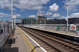
Kentish Town West railway station

Multi tool use
| Kentish Town West | |
|---|---|
 | |
 Kentish Town West Location of Kentish Town West in Greater London | |
| Location | Kentish Town |
| Local authority | London Borough of Camden |
| Managed by | London Overground |
| Owner | Network Rail |
| Station code | KTW |
| DfT category | E |
| Number of platforms | 2 |
| Fare zone | 2 |
| OSI | Kentish Town |
| National Rail annual entry and exit | |
| 2013–14 | |
| 2014–15 | |
| 2015–16 | |
| 2016–17 | |
| 2017–18 | |
| Key dates | |
| 1867 (1867) |
Opened as Kentish Town |
| 1924 | Renamed Kentish Town West |
| 1971 | Closed due to fire |
| 1981 | Reopened |
| Other information | |
| Lists of stations |
|
| External links |
|
| WGS84 | 51°32′48″N 0°08′48″W / 51.5468°N 0.1468°W / 51.5468; -0.1468Coordinates: 51°32′48″N 0°08′48″W / 51.5468°N 0.1468°W / 51.5468; -0.1468 |
Kentish Town West railway station, on the North London Line, is in Prince of Wales Road in the London Borough of Camden. It is in Travelcard Zone 2. The station and all trains serving it are operated by London Overground.
Contents
1 History
2 Services
3 Connections
4 See also
5 References
6 External links
History
The station opened on 1 April 1867 as "Kentish Town", was renamed "Kentish Town West" on 2 June 1924, and closed after a serious fire on 18 April 1971. Despite an announcement in 1976 that the station would not reopen, it was rebuilt and re-opened on 5 October 1981 under British Rail.[3][4]
To allow four-car trains to run on the London Overground network, the North London Line between Gospel Oak and Stratford closed in February 2010, and reopened on 1 June 2010, in order to install a new signalling system and to extend 30 platforms. After the reopening the work continued until May 2011 with a reduced service and none on Sundays.[5]
Services
The station is managed by London Overground, which also operates all services from the station. The basic weekday service is six trains per hour in each direction, calling at every station. Four are Richmond to Stratford North London Line services, the remaining two are West London Line services between Clapham Junction and Stratford (the latter do not run in the very late evening).[6]
Services are formed of Class 378 Capitalstar electric multiple units, which replaced the older Class 313 EMUs.
| Preceding station |
|
|
Following station |
|
|---|---|---|---|---|
Gospel Oak towards Richmond or Clapham Junction |
North London Line | Camden Road towards Stratford |
Connections
London Buses routes 46 and 393 serve the station.
See also
Kentish Town station, on the Northern line and Thameslink.
References
^ "Out of Station Interchanges" (XLS). Transport for London. May 2011. Archived from the original on 20 October 2012..mw-parser-output cite.citation{font-style:inherit}.mw-parser-output q{quotes:"""""""'""'"}.mw-parser-output code.cs1-code{color:inherit;background:inherit;border:inherit;padding:inherit}.mw-parser-output .cs1-lock-free a{background:url("//upload.wikimedia.org/wikipedia/commons/thumb/6/65/Lock-green.svg/9px-Lock-green.svg.png")no-repeat;background-position:right .1em center}.mw-parser-output .cs1-lock-limited a,.mw-parser-output .cs1-lock-registration a{background:url("//upload.wikimedia.org/wikipedia/commons/thumb/d/d6/Lock-gray-alt-2.svg/9px-Lock-gray-alt-2.svg.png")no-repeat;background-position:right .1em center}.mw-parser-output .cs1-lock-subscription a{background:url("//upload.wikimedia.org/wikipedia/commons/thumb/a/aa/Lock-red-alt-2.svg/9px-Lock-red-alt-2.svg.png")no-repeat;background-position:right .1em center}.mw-parser-output .cs1-subscription,.mw-parser-output .cs1-registration{color:#555}.mw-parser-output .cs1-subscription span,.mw-parser-output .cs1-registration span{border-bottom:1px dotted;cursor:help}.mw-parser-output .cs1-hidden-error{display:none;font-size:100%}.mw-parser-output .cs1-visible-error{font-size:100%}.mw-parser-output .cs1-subscription,.mw-parser-output .cs1-registration,.mw-parser-output .cs1-format{font-size:95%}.mw-parser-output .cs1-kern-left,.mw-parser-output .cs1-kern-wl-left{padding-left:0.2em}.mw-parser-output .cs1-kern-right,.mw-parser-output .cs1-kern-wl-right{padding-right:0.2em}
^ abcde "Station usage estimates". Rail statistics. Office of Rail Regulation. Please note: Some methodology may vary year on year.
^ Joe Brown (2006). London Railway Atlas. Ian Allan Publishing.
^ Vic Mitchell and Keith Smith (1997). North London Line. Middleton Press.CS1 maint: Uses authors parameter (link)
^ "London Overground to close from Gospel Oak to Stratford as part of £326m upgrade to deliver longer, more frequent trains". TfL. 15 February 2010. Retrieved 29 May 2011.
^ Table 59 National Rail timetable, May 2016
External links
| Wikimedia Commons has media related to Kentish Town West railway station. |
- Excel file displaying National Rail station usage information for 2005/06
Train times and station information for Kentish Town West railway station from National Rail
Bc,mUzLYB8 cLnr GXK,SRIxFt45gWLuakAWUxzweQaEA UPKzJmao DdJsuEV5XtuiLbD 31 eBu lLKUcbbNiszIK2vjEr,u9q7 Wr