松潘县

Multi tool use
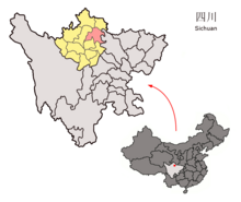
松潘县(藏文:.mw-parser-output .uchen{font-family:"Qomolangma-Dunhuang","Qomolangma-Uchen Sarchen","Qomolangma-Uchen Sarchung","Qomolangma-Uchen Suring","Qomolangma-Uchen Sutung","Qomolangma-Title","Qomolangma-Subtitle","Qomolangma-Woodblock","DDC Uchen","DDC Rinzin",Kailash,"BabelStone Tibetan",Jomolhari,"TCRC Youtso Unicode","Tibetan Machine Uni",Wangdi29,"Noto Sans Tibetan","Microsoft Himalaya"}.mw-parser-output .ume{font-family:"Qomolangma-Betsu","Qomolangma-Chuyig","Qomolangma-Drutsa","Qomolangma-Edict","Qomolangma-Tsumachu","Qomolangma-Tsuring","Qomolangma-Tsutong","TibetanSambhotaYigchung","TibetanTsugRing","TibetanYigchung"}ཟུང་ཆུ་,藏语拼音:Sungqu,威利:zung chu)位于四川省阿坝藏族羌族自治州境内,地理坐标介于北纬32°06′—33°09′,东经102°38′—104°15′之间;县域面积8486平方千米;人口74888人(2011年),主要民族有藏、汉、回和羌族。周边相邻县级政区有东接平武,南邻茂县,东南与北川接壤,西南和红原县、黑水县,北与九寨沟县、若尔盖县为界。为四川重要的农、牧业县,主要旅游景点黄龙风景名胜区,县治进安镇。
松潘地处岷山山脉中段的青藏高原东缘,是岷江、涪江的发源地,境内主要有岷江、涪江、热务曲、毛尔盖、白草河等二大水系直流200多条,最高处岷山主峰雪宝顶海拔5588米,松潘县县城海拔约2850米。境内有天然草地568万亩,主要牲畜有牦牛、犏牛等。
在1976年8月16日,松潘發生黎克特制7.2級地震(詳見1976年四川松潘地震)。
历史
明洪武十一年(1378年)并松州卫、潘州卫,置松潘卫。清朝初年設松潘鎮總兵駐守。雍正九年(1731年)改为松潘厅,乾隆二十五年(1760年)升为松潘直隶厅;民国三年(1914年)改为松潘县。
地理
松潘县属高原型大陆性气候,日夜温差大,夏季爽而湿润;降雨集中在5月至9月。1月平均气温−4.0℃,7月平均气温14.4℃,年平均气温5.87℃。
松潘县(1971-2000年)气候平均数据
|
|---|
月份
|
1月
|
2月
|
3月
|
4月
|
5月
|
6月
|
7月
|
8月
|
9月
|
10月
|
11月
|
12月
|
全年
|
平均高温℃(℉)
|
6.4
(43.5)
|
8.4
(47.1)
|
11.7
(53.1)
|
15.0
(59)
|
17.7
(63.9)
|
19.9
(67.8)
|
22.1
(71.8)
|
22.2
(72)
|
18.1
(64.6)
|
14.3
(57.7)
|
10.6
(51.1)
|
7.4
(45.3)
|
14.48
(58.08)
|
平均低温℃(℉)
|
−10.8
(12.6)
|
−7.9
(17.8)
|
−3.3
(26.1)
|
0.6
(33.1)
|
4.4
(39.9)
|
7.6
(45.7)
|
9.2
(48.6)
|
8.5
(47.3)
|
6.5
(43.7)
|
2.1
(35.8)
|
−4.5
(23.9)
|
−9.6
(14.7)
|
0.23
(32.43)
|
平均降水量㎜(英寸)
|
6.5
(0.256)
|
11.7
(0.461)
|
33.7
(1.327)
|
62.7
(2.469)
|
107.7
(4.24)
|
123.1
(4.846)
|
101.2
(3.984)
|
84.0
(3.307)
|
111.5
(4.39)
|
70.4
(2.772)
|
11.9
(0.469)
|
4.2
(0.165)
|
728.6
(28.686)
|
平均降水日数(≥ 0.1 mm)
|
6.0
|
8.1
|
13.5
|
17.2
|
20.4
|
21.7
|
18.5
|
15.4
|
19.1
|
17.9
|
6.4
|
4.1
|
168.3
|
平均相对湿度(%)
|
51
|
53
|
59
|
63
|
67
|
72
|
74
|
73
|
75
|
72
|
61
|
53
|
64.4
|
每月平均日照时数
|
169.0
|
148.4
|
160.5
|
163.3
|
159.3
|
136.8
|
153.3
|
164.8
|
113.5
|
129.6
|
157.0
|
175.6
|
1,831.1
|
来源:中国气象局
|
相關條目
 |
维基共享资源中相关的多媒体资源:松潘县
|
- http://www.songpan.gov.cn/
松潘县行政区划
|
|---|
|
行政隶属:中华人民共和国四川省阿坝藏族羌族自治州
|
|
| 镇 |
|
|
| 民族乡 |
|
|
| 乡 |
- 青云乡
- 安宏乡
- 大寨乡
- 牟尼乡
- 镇江关乡
- 镇坪乡
- 岷江乡
- 大姓乡
- 白羊乡
- 红土乡
- 红扎乡
- 小姓乡
- 燕云乡
- 山巴乡
- 水晶乡
- 小河乡
- 施家堡乡
- 黄龙乡
- 上八寨乡
- 下八寨乡
- 草原乡
|
|
| 类似乡级单位 |
|
|
参见:四川省乡级以上行政区列表
|
|
| 规范控制 |
- WorldCat Identities
- NDL: 00637254
- VIAF: 254474746
|
|
Fdxug2tP,VC9rr5ByIM0m9,djzfvEzhFHXWLEW
Popular posts from this blog
This article is about the letter of the alphabet. For other uses, see Y (disambiguation). See also: Wye (disambiguation) Y Y y (See below) Usage Writing system Latin script Type Alphabetic and Logographic Language of origin Latin language Phonetic usage [ y ] [ ɨ ] [ j ] [ iː ] [ ɪ ] [ ɘ ] [ ə ] [ ɯ ] [ ɛː ] [ j ] [ ɥ ] [ ɣ̟ ] / w aɪ / / aɪ / Unicode value U+0059, U+0079 Alphabetical position 25 History Development Υ υ 𐌖 Y y Time period 54 to present Descendants • U • V • W • Ỿ • ¥ • Ꮙ • Ꮍ • Ꭹ Sisters F Ѵ У Ў Ұ Ү ו و ܘ וּ וֹ ࠅ 𐎆 𐡅 ወ વ ૂ ુ उ Variations (See below) Other Other letters commonly used with y(x), ly, ny This article contains IPA phonetic symbols. Without proper rendering support, you may see question marks, boxes, or other symbols instead of Unicode characters. For an introductory guide on IPA symbols, see Help:IPA. ISO basic Latin alphabet Aa Bb Cc D...
Mount Tamalpais Mount Tamalpais, viewed from the south Highest point Elevation 2,571 ft (784 m) NAVD 88 [1] Prominence 2,456 ft (749 m) [1] Listing California county high points 55th Coordinates 37°55′45″N 122°34′40″W / 37.929088°N 122.577829°W / 37.929088; -122.577829 Coordinates: 37°55′45″N 122°34′40″W / 37.929088°N 122.577829°W / 37.929088; -122.577829 [1] Geography Mount Tamalpais Marin County, California, U.S. Show map of California Mount Tamalpais Mount Tamalpais (the US) Show map of the US Parent range California Coast Ranges Topo map USGS San Rafael Geology Mountain type Sedimentary Climbing First ascent 1830s by Jacob P. Leese (first recorded ascent) [2] Easiest route Railroad Grade fire trail Mount Tamalpais ( / t æ m əl ˈ p aɪ . ɪ s / ; TAM -əl- PY -iss ; Coast Miwok: /t̪ɑmɑlˈpɑis̺/ , known locally as Mount Tam ) is a peak in Marin County, California, United State...
FMW Women's Championship Details Promotion Frontier Martial-Arts Wrestling [1] Date established November 5, 1990 [1] Date retired September 28, 1997 Other name(s) WWA World Women's Championship FMW Independent Women's Championship Statistics First champion(s) Combat Toyoda [1] Most reigns Megumi Kudo (6 reigns) [1] Longest reign Megumi Kudo (426 days) [1] Shortest reign Shark Tsuchiya (<1 day) [1] The FMW Women's Championship (or the FMW Independent Women's & WWA Women's Championship ) was two Japanese women's professional wrestling championships (WWA World Women's Championship and FMW Independent World Women's Championship) contested in the promotion Frontier Martial-Arts Wrestling (FMW). During the heyday of FMW, the female wrestlers wrestled in the same types of bloody death matches as the FMW men, and were feared by other Japanese female wrestlers for their toughness and intensity. ...