普利亚大区

Multi tool use
 提示
提示:本条目的主题不是
阿普利亚 (摩托车公司)。
body.skin-minerva .mw-parser-output table.infobox caption{text-align:center}
普利亞
Puglia
|
|---|

旗幟
|

徽章
|
|
|
坐标:41°00′31″N 16°30′46″E / 41.008611111111°N 16.512777777778°E / 41.008611111111; 16.512777777778
|
| 國家 |
意大利
|
| 首府 |
巴里
|
政府
|
|---|
| • 首腦 |
米凯·埃米利亚诺 (民主党) |
面积
|
|---|
• 总计
|
19,358 平方公里(7,474 平方英里) |
人口(2012-10-30)
|
|---|
| • 總計 |
4,045,949 |
• 密度
|
210/平方公里(540/平方英里) |
| 居民称谓 |
Apulian(s) / Puglian(s) / Pugliese / Pugliesi |
| 时区 |
CET (UTC+1) |
• 夏时制
|
CEST(UTC+2) |
| GDP |
€695[1]億(2008) |
| 人均GDP |
€16,900[2] (2008) |
| NUTS地區 |
ITF |
| 網站 |
www.regione.puglia.it
|
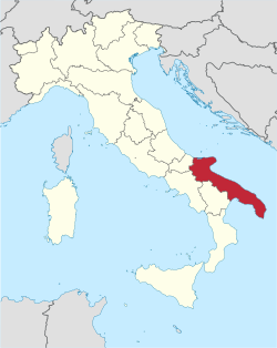
普利亚(意大利語:Puglia;拉丁語:Apulia),也译作阿普利亚[3],是意大利南部的一个大区,东邻亚得里亚海,东南面临爱奥尼亚海,南面则邻近奥特朗托海峡及塔兰托湾。该区南部知名的萨伦托半岛,组成了意大利「皮靴」的一部分。大区面积19,366km²,人口4,023,957人(1991年)。
该区还与其它意大利大区连接,北邻莫利塞大区,西临坎帕尼亚大区,及西南面的巴斯利卡塔大区。大区隔着亚得里亚海及爱奥尼亚海与希腊和阿尔巴尼亚相邻。大区扩展至北面远处的莫特—格加奴地区,是第二次布匿战争中最后一次围城所发生的地方。
历史
在古代只有该区北部被称为普利亚;南面则称作卡拉布里亚,被称呼为是意大利“皮靴”的脚尖。于公元前4世纪被罗马人征服之前,该区是古意大利人及希腊殖民者定居之地方。公元五世纪西罗马帝国灭亡之后,普利亚依次被东哥特人、伦巴第人及拜占庭帝国占据。
于11世纪,普利亚被诺曼人征服;罗拔·古伊斯格(Robert Guiscard)于1059年建立了普利亚公国。于11世纪末诺曼人征服了西西里之后,巴勒莫取代了美菲(Melfi,现时普利亚西部)成为了诺曼统治权力的中心,之后普利亚仅仅只是起初的西西里王国,和接着的那不勒斯王国的一个省分。由12世纪未到13世纪早期,普利亚是都是霍亨斯陶芬王朝的皇帝喜爱的一个居住地点,特别是腓特烈二世。海岸地区后来被奥斯曼帝国及威尼斯人占领。于1861年,该区加入了意大利。
封建制度长期盛行于普利亚的农村地区;社会和农业的革命于19世纪进展缓慢,到20世纪中期进展的步伐才加快。
普利亚地区于11世纪-13世纪时的建筑特色受到古希腊、阿拉伯、诺曼人及比萨建筑风格的影响。于大区內,巴里及莱切市都設有大学。
地理
巴里是普利亚大区的首府,大区分成了数个省分(亦同时是那些省分的首府),包括巴里省、布林迪西省、福贾省、莱切省及塔兰托省。在2005年决定组成一个新省分巴列塔—安德里亚—特拉尼省(Barletta-Andria-Trani)。大区内主要是平原地带,大区内的低洼海岸则被北方格加奴山区阻断,区内的中北部都有山脉。
经济
普利亞在過去很長時間,都主要以農業為主,是全意大利發展比較遲緩地區之一。但自千禧年起,亦開始有一些工業園的設立,包括紡織、鋼鐵、機械、石油等等。意大利石油公司埃尼、汽車配件商Magneti Marelli和航天公司芬梅卡尼卡都有在普利亞設廠。
参考文献
^ Regional gross domestic product by NUTS 2 regions - million. Eurostat. [8 September 2013].
^ EUROPA – Press Releases – Regional GDP per inhabitant in 2008 GDP per inhabitant ranged from 28% of the EU27 average in Severozapaden in Bulgaria to 343% in Inner London
^ 普利亚大区介绍--中华人民共和国驻意大利共和国大使馆经济商务参赞处
意大利行政區劃
|
|---|
|
| 普通大区 |
阿布鲁佐 | 巴西利卡塔 | 卡拉布里亚 | 坎帕尼亚 | 艾米利亚-罗马涅 | 拉齐奥 | 利古里亚 | 伦巴第 | 马尔凯 | 莫利塞 | 皮埃蒙特 | 普利亚 | 托斯卡纳 | 翁布里亚 | 威尼托
|
|
|
| 有自治权的大区 |
弗留利-威尼斯朱利亚 | 撒丁 | 西西里 | 特伦蒂诺-上阿迪杰 | 瓦莱达奥斯塔
|
|
 意大利普利亚大区行政区划
|
|---|
|
首府:巴里
|
|
| 1 广域市 |
巴里廣域市(原巴里省)
|
|
|
5 省
|
巴列塔-安德里亚-特拉尼省 | 布林迪西省 | 福贾省 | 莱切省 | 塔兰托省
|
|
| 规范控制 |
- WorldCat Identities
- GND: 4002508-1
- ISNI: 0000 0004 1754 9737
- NKC: ge136683
- VIAF: 248501285
|
|
4KP,SE1Jqmft5HewQY2etO E27j88Vdp,xtSggGOlp tDE3wr4qLixh4ev2ba egIOiJkn
Popular posts from this blog
This article is about the letter of the alphabet. For other uses, see Y (disambiguation). See also: Wye (disambiguation) Y Y y (See below) Usage Writing system Latin script Type Alphabetic and Logographic Language of origin Latin language Phonetic usage [ y ] [ ɨ ] [ j ] [ iː ] [ ɪ ] [ ɘ ] [ ə ] [ ɯ ] [ ɛː ] [ j ] [ ɥ ] [ ɣ̟ ] / w aɪ / / aɪ / Unicode value U+0059, U+0079 Alphabetical position 25 History Development Υ υ 𐌖 Y y Time period 54 to present Descendants • U • V • W • Ỿ • ¥ • Ꮙ • Ꮍ • Ꭹ Sisters F Ѵ У Ў Ұ Ү ו و ܘ וּ וֹ ࠅ 𐎆 𐡅 ወ વ ૂ ુ उ Variations (See below) Other Other letters commonly used with y(x), ly, ny This article contains IPA phonetic symbols. Without proper rendering support, you may see question marks, boxes, or other symbols instead of Unicode characters. For an introductory guide on IPA symbols, see Help:IPA. ISO basic Latin alphabet Aa Bb Cc D...
Mount Tamalpais Mount Tamalpais, viewed from the south Highest point Elevation 2,571 ft (784 m) NAVD 88 [1] Prominence 2,456 ft (749 m) [1] Listing California county high points 55th Coordinates 37°55′45″N 122°34′40″W / 37.929088°N 122.577829°W / 37.929088; -122.577829 Coordinates: 37°55′45″N 122°34′40″W / 37.929088°N 122.577829°W / 37.929088; -122.577829 [1] Geography Mount Tamalpais Marin County, California, U.S. Show map of California Mount Tamalpais Mount Tamalpais (the US) Show map of the US Parent range California Coast Ranges Topo map USGS San Rafael Geology Mountain type Sedimentary Climbing First ascent 1830s by Jacob P. Leese (first recorded ascent) [2] Easiest route Railroad Grade fire trail Mount Tamalpais ( / t æ m əl ˈ p aɪ . ɪ s / ; TAM -əl- PY -iss ; Coast Miwok: /t̪ɑmɑlˈpɑis̺/ , known locally as Mount Tam ) is a peak in Marin County, California, United State...
FMW Women's Championship Details Promotion Frontier Martial-Arts Wrestling [1] Date established November 5, 1990 [1] Date retired September 28, 1997 Other name(s) WWA World Women's Championship FMW Independent Women's Championship Statistics First champion(s) Combat Toyoda [1] Most reigns Megumi Kudo (6 reigns) [1] Longest reign Megumi Kudo (426 days) [1] Shortest reign Shark Tsuchiya (<1 day) [1] The FMW Women's Championship (or the FMW Independent Women's & WWA Women's Championship ) was two Japanese women's professional wrestling championships (WWA World Women's Championship and FMW Independent World Women's Championship) contested in the promotion Frontier Martial-Arts Wrestling (FMW). During the heyday of FMW, the female wrestlers wrestled in the same types of bloody death matches as the FMW men, and were feared by other Japanese female wrestlers for their toughness and intensity. ...


